Mid-Century City Plan

Much of my research for Hidden Waters of New York City does not involve paddling, swimming, or walking away from my desk. It involves having a grasp of GIS: geographic information systems where one compares maps of the same location to determine what lies beneath the surface. When the internet is down and there is no time to take the bus to the New York Public Library, I have an excellent resource at the Five Boro Shop on Randalls Island.

title card.JPG

It is the 1952 Department of City Planning map that shows the city as the agency envisioned it in the near future. The close-up above of central Staten Island shows the borough covered by a grid with two never-built highways traversing the borough.  The map has much to teach its viewers on how much of the 1952 plan was realized at present time. Continue reading

Ponds of Borough Park, Brooklyn

In today’s polarized society, people often put themselves into ideological silos and see little in common with members of other political persuasions, interests, and beliefs. Although the Hamodia newspaper is designed for a certain sector of Orthodox Jews, I can argue that its material can educate anyone who picks it up. Can you imagine an Irish-American historian from Queens reading a Hamodia article?

An example of the cross-over appeal here is Yitzchok Shteierman’s Pioneers of Boro Park column, which documents the neighborhood’s history. This is the type of work that Kevin Walsh does on Forgotten-NY.

hamodi.jpg

Where do the literary paths of Shteierman, Walsh, and I intersect? At Webster’s Pond, a long-buried waterway deep in the heart of Borough Park, Brooklyn.

Continue reading

Lispenard’s Meadow, Manhattan

Among the most helpful Twitter accounts that relates to New York City history is @Discovering_NYC, run by a local tour guide who shares old photos, maps, and illustrations of the city’s past. Over the weekend, it posted a map of Lispenard’s Meadow, the long-forgotten wetland in what is now the Tribeca neighborhood of lower Manhattan.

lisp 1800.JPG

At the turn of the 19th century, the meadow was on the northern periphery of New York City. Above is an 1800 illustration of the meadow by Alexander Anderson, looking towards the Hudson River. It contained three creeks within it, occluding one that drained from Collect Pond. That creek became the route of Canal Street.

Continue reading

Charles W. Leng’s Wonderful Map

When I am not getting my shoes wet by exploring streams, I look carefully at old maps and aerials in search of where the hidden waterways once flowed in the open. Last week, I conducted a park inspection in the far-off Travis neighborhood of Staten Island, where the Parks Department has a plant nursery.

davis-full-resized

The plant nursery is a former farm, and on one of its walls is a 1968 reproduction of Charles W. Leng’s 1896 Map of Staten Island with Ye Olde Names & Nicknames by William T. Davis. There is so much information on it relating to the island borough’s history. Let’s zoom in on a few details. Continue reading

Last word on Mussel Island

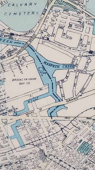
musselmap.jpgWhile visiting a Parks work shop this morning, I found a 1988 Hagstrom map hanging on the wall with Mussel Island, Newtown Creek’s phantom island making its appearance. Also on the map, Hagstrom’s Maspeth office, the now-abandoned stations on the LIRR Montauk Line, the now-defunct Brooklyn Union Gas Company…

Towards the bottom of the map is the now-forgotten Evergreen Branch, a freight rail line running along the Brooklyn-Queens border.

No one ever lived on Mussel Island, it was a small and marshy piece of land at the confluence of Maspeth Creek and Newtown Creek.

Some Hagstrom Maps put the phantom island entirely within Brooklyn waters while other maps have the island shared by the two boroughs.

Divided Phantom Island
hag bk.jpg

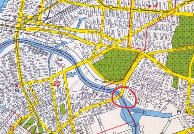
Relying on aerial surveys of Mussel Island from the 1920s, the island is in the middle of the stream, giving both boroughs a claim for it, but older maps show it as outside of Brooklyn. With the island’s disappearance, the borough border line appeared on most maps in the middle of Newtown Creek, where Mussel Island once was. When the island went from real to phantom, Hagstrom had it divided between the boroughs, as in the 1949 map above. Circled is Kosciuszko Bridge, the highest crossing above the stream.

Was Hagstrom Correct?
mus air.JPG

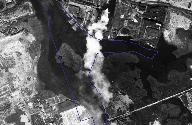
Relying on the DoITT CityMap that blends the present shorelines with a 1924 aerial survey, we see Mussel Island almost entirely within the present-day waters, with a tiny portion on what is now Brooklyn land. Back in 1924, the island was closer to Queens, and with 19th century maps as a reference, when it existed this island belonged to Queens.

Founded in 1916, Hagstrom was once the go-to authority for maps of the city and nearby cities. With the advent of GPS and satellite surveys, hand-drawn maps became obsolete. Hagstrom closed its Midtown Manhattan map shop in 2010, and was acquired by the Kappa Publishing Group that same year. Without Hagstrom, there is no Mussel Island.

Mid-Century GIS

As you may know, much of my research for Hidden Waters of New York City does not involve paddling, swimming, or walking away from my desk. It involves having a grasp of GIS: geographic information systems where one compares maps of the same location to determine what lies beneath the surface. Even when the internet is down and there is no time to take the bus to the New York Public Library, I have an excellent resource down the hall from my desk at the Parks Department headquarters.

0851917b-339e-45a1-9f8e-014a67fba95e.jpg

The topographical map above is undated. Taking a closer look at what’s there and what’s not there helps narrow down the approximate time of its publication and take stock of the changes on the city’s landscape since this map appeared. Continue reading

Water Map for the Outer Boroughs

In 1874, a map like none other was unfurled before city planners by Col. Egbert Ludovicus Viele. Designed in a time when the city was rapidly expanding north thanks to advances in public transportation, Viele captured for posterity the locations of the island’s springs, brooks, creeks, and swamps, where land meets landfill, tracing former shorelines and hilltops. To this day, this map is used by structural engineers in Manhattan, who check it for buried streams when constructing buildings, tunnels and utility lines.

viele 1

With 82 of the 101 hidden city streams in my book located outside of Manhattan, what map did I use to find these waterways? Continue reading