Wienfluss, Vienna

Flowing through nine European countries, the Danube River is full of history along its 2,860-mile course. The oldest capital city on the Danube is Vienna, where the rivers enters the Pannonian Plain, splitting briefly into branches and collecting tributaries along the way. To reduce impact from flooding and improve navigation for boats, the main course of the Danube was straightened as it flows through Vienna, while its old natural course kept its winding route with a concrete bulkhead as the Donaukanal. A tributary of this “canal” is a river that shares the city’s name.

wien 3

It isn’t clear whether the ancient city received its name from the river or vice versa. Vienna’s founding predates the Roman Empire. Since 1899, the Vienna River has been confined to a concrete channel within the borders of the city, and in the section between Naschmarkt and Stadtpark, it runs through a tunnel. Continue reading

Last word on Mussel Island

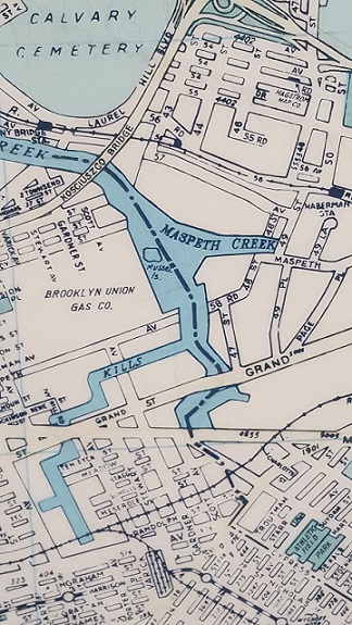
musselmap.jpgWhile visiting a Parks work shop this morning, I found a 1988 Hagstrom map hanging on the wall with Mussel Island, Newtown Creek’s phantom island making its appearance. Also on the map, Hagstrom’s Maspeth office, the now-abandoned stations on the LIRR Montauk Line, the now-defunct Brooklyn Union Gas Company…

Towards the bottom of the map is the now-forgotten Evergreen Branch, a freight rail line running along the Brooklyn-Queens border.

No one ever lived on Mussel Island, it was a small and marshy piece of land at the confluence of Maspeth Creek and Newtown Creek.

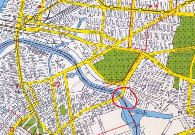
Some Hagstrom Maps put the phantom island entirely within Brooklyn waters while other maps have the island shared by the two boroughs.

Divided Phantom Island
hag bk.jpg

Relying on aerial surveys of Mussel Island from the 1920s, the island is in the middle of the stream, giving both boroughs a claim for it, but older maps show it as outside of Brooklyn. With the island’s disappearance, the borough border line appeared on most maps in the middle of Newtown Creek, where Mussel Island once was. When the island went from real to phantom, Hagstrom had it divided between the boroughs, as in the 1949 map above. Circled is Kosciuszko Bridge, the highest crossing above the stream.

Was Hagstrom Correct?
mus air.JPG

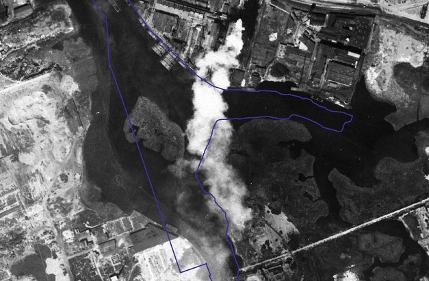
Relying on the DoITT CityMap that blends the present shorelines with a 1924 aerial survey, we see Mussel Island almost entirely within the present-day waters, with a tiny portion on what is now Brooklyn land. Back in 1924, the island was closer to Queens, and with 19th century maps as a reference, when it existed this island belonged to Queens.

Founded in 1916, Hagstrom was once the go-to authority for maps of the city and nearby cities. With the advent of GPS and satellite surveys, hand-drawn maps became obsolete. Hagstrom closed its Midtown Manhattan map shop in 2010, and was acquired by the Kappa Publishing Group that same year. Without Hagstrom, there is no Mussel Island.

Highbridge Pool, Manhattan

In selecting the waterways featured in my book, the question on reservoirs determined how much of the city would be covered in the book and the size of the book. Over the centuries, the city’s thirst was quenched by reservoirs placed on high location from which gravity took the flow to homes and businesses. Some reservoirs were given naturalistic appearances, such as the one in Central Park. Silver Lake on Staten Island was transformed into a reservoir; Mount Prospect Reservoir was eliminated after becoming obsolete. But only one former reservoir in the city was transformed into a public swimming pool: the one in High Bridge Park.

113954

As upper Manhattan does not have as many historical streams as its middle and downtown parts, a chapter on Highbridge Reservoir puts the neighborhood of Washington Heights on the Hidden Waters map. Continue reading

Furman Island, Queens

When taking the Grand Street Bridge across Newtown Creek, one notices the avenue narrowing to two lanes as it uses a century-old swing drawbridge to cross Newtown Creek. Not known to travelers today is that this creek used to have two islands in it at its confluence with Maspeth Creek.

maspeth 2013

Nothing remains of the smaller Mussel Island, while the larger Furman Island has been fused to Queens. The former island is almost entirely industrial in use, with the exception of a small green piece of shoreline at a dead of 58th Road at 47th Street, where Maspeth Avenue once crossed over Newtown Creek. Continue reading

City Creek, Salt Lake City

The state of Utah was founded on very lofty ideas and the Mormon settlers who developed the state applied a few biblical names to the map: Jordan River, Zion, and Moab. The capital city however has a plain name, Salt Lake City and the stream that continued to the city’s growth also has a simple name: City Creek.

citycr3.jpg

Today this hidden urban stream is associated with a shopping center in the city’s downtown, where a channel resembling the creek flows through the mall to the delight of shoppers. Continue reading

Clove Lake, Staten Island

Staten Island is a latecomer among the city’s boroughs when it comes to urbanization, as it retained its small-town appearance for more than a half-century after becoming part of New York City. The land around Clove Lake was proposed as a park in 1897 with its trails and facilities completed in the 1930s. It was the first large park in the borough, a local counterpart to Central Park and Prospect Park.

clove1

A former estate of colonial governor Thomas Dongan, the valley around Clove Brook contains dense forest that hides the Ordovician period serpentine rock that forms Emerson and Grymes hills on either side of the valley.

Continue reading

Barbadoes Basin, Queens

The northern shore of the Rockaway peninsula in Queens is one of industry, derelict piers and solitude overlooking Jamaica Bay with the noise of airplanes using the nearby JFK Airport.

IMG_2129

Unlike the sandy and straight ocean side, the bay side is punctured with inlets that shifted with the currents and storms but over the past century have been bulkheaded, assuming their present outlines. Continue reading

Bronx Zoo Boathouse

I recently found a postcard that shows a boathouse on the Bronx River but had no idea where this boathouse stood. By its appearance, it is a counterpart to the boathouses of Central Park and Prospect Park but while those parks are also located at the centers of their respective boroughs, most of Bronx Park is not an open park. For more than a century, its land was set aside for the Bronx Zoo and the New York Botanical Garden.

zoo card 1

So if this boathouse was within the park, what happened to it and what’s there today? Continue reading