The northern shore of the Rockaway peninsula in Queens is one of industry, derelict piers and solitude overlooking Jamaica Bay with the noise of airplanes using the nearby JFK Airport.

Unlike the sandy and straight ocean side, the bay side is punctured with inlets that shifted with the currents and storms but over the past century have been bulkheaded, assuming their present outlines.
Where it is

As the Rockaway peninsula’s shape kept shifting over time, I chose the 1891 Bien atlas as an early reference for Barbadoes Basin. Zooming in on Oceanus, a development at the railroad crossing leading to the mainland, we see two knobs of land above its name. According to a 1988 archaeological survey of this area, these knobs were formerly islands, the 15-acre Horse Island and a smaller unnamed 5-acre island. The survey was not able to pinpoint the exact moment when the islands were fused to the Rockaway peninsula and concludes that the transformation began with Remington Vernam’s Arverne development, which was founded in 1882. Arverne is a pun on the developer’s signature: R. Vernam.
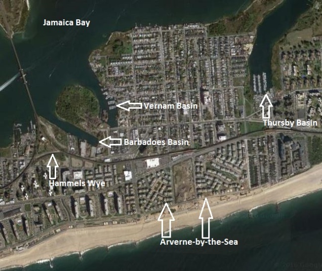
Its success inspired Vernam to lay out streets on the north side of the train tracks, the “bay side” of the peninsula. Vernam died in 1907, and the north side was was sold to the Sommerville Realty Company which continued the filling operations that turned the two marshland islands into knobs of attached land. The larger knob became the Sommerville section of Arverne while the smaller knob was designated as a preserve in 1997 after decades as an illegal dumping site.
Industry Arrives

Less than a decade after Vernam’s death, most of the waterfront clubhouses were replaced by lumber yards, coal depots, and a trash incinerator, ruining the summer bungalow colonies on Arverne’s bay side. As seen on the above 1912 Sanborn map, Barbadoes Basin’s industries include an ice factory, auto shops, lumber yard and a coal yard. Rockaway Wave contributor Emil Lucev has a detailed history of industries along Babadoes Basin from the 1920s to the present day.
What about its name?

As I mentioned, Barbadoes Basin is one of a few indentations on Rockaway’s northern shore, others include Vernam Basin, Thursby Basin, Norton Basin, and Mott Basin. Barbadoes reaches almost to the elevated train tracks of the Far Rockaway line. I looked at old newspaper articles and maps, none providing any clues as to why this inlet carries the name of Rihanna’s birthplace.
The misspelling does not surprise me. A century ago, plenty of foreign places were misspelled by Americans. Eventually places became standardized thanks to institutions such as National Geographic Society and the U. S. Geological Survey. Perhaps the basin’s name was an attempt to give this corner of the Rockaways a connection to a warmer, exotic destination.
Kohlreiter Square
While exploring Arverne, I revisited a small park next to the Beach 67th Street station that carries a name closely associated with the neighborhood’s past.

In the summer of 2015, real estate broker Donald Kohlreiter contacted the Parks Department about a little-known public space next to the station that had the last name misspelled. I ordered a new sign with the corrected spelling and drafted a historical sign to explain the namesake. Although that sign has yet to be installed, I created a Wikipedia entry on this park, so that residents of the new Arverne-by-the-Sea could learn about the history of this park.
Campagna Square
On the south side of the elevated tracks in the Arverne-by-the-Sea development is a public space that has a monument honoring Thomas Campagna. A consulting engineer at Queens Borough Hall, he was responsible for demapping dozens of unused streets within the Arverne urban renewal area and plotting new streets onto the map that would have the peninsula’s newest neighborhood on them.

I’ve been to Arverne and Hammels back in 2011, when I wrote a detailed photo essay on these neighborhoods for Forgotten-NY.
In the News:
NY Daily News reports on this past weekend’s Hong Kong Dragon Boat Festival in Flushing Meadows-Corona Park
Atlas Obscura writes about Marine Park’s connection to the 1936 Summer Olympics in Germany. This blog is mentioned in the article.
The Essential Online, not sure if it’s a news site or clickbait, has a photo essay on cities around the world that are transforming their urban rivers into linear parks.

EXCELLENT and very Insightful read, now if you could give us the name of the “mini park” with the boating dock, on Flatlands and Williams Avenue (now used by a construction company, near a senior citizens building) in Canarsie, Brooklyn, NY you will have given me back 40 years of precious memories. Thank you.
LikeLike