Staten Island is a latecomer among the city’s boroughs when it comes to urbanization, as it retained its small-town appearance for more than a half-century after becoming part of New York City. The land around Clove Lake was proposed as a park in 1897 with its trails and facilities completed in the 1930s. It was the first large park in the borough, a local counterpart to Central Park and Prospect Park.

A former estate of colonial governor Thomas Dongan, the valley around Clove Brook contains dense forest that hides the Ordovician period serpentine rock that forms Emerson and Grymes hills on either side of the valley.
Where it is

Clove’s name is an English corruption of the Dutch term kloven, meaning cleft. On the 1887 Beers Map above, Clove Lake is the southernmost in a chain of lakes on Clove Brook, which originated at a spring near the present-day intersection of Little Clove Road and Logan Street in the Sunnyside neighborhood. At the time, its shoreline properties included water companies, ice manufacturers and farms.
The valley was acquired by the city for parkland between 1921 and 1923 following decades of impassioned advocacy by residents William T. Davis, Charles Leng, and Central Park architect Frederick Law Olmsted. Along with Silver Lake, they envisioned Clove Valley as the island’s “Central Park.”
At the Start

A couple of blocks downhill from its historic headwaters is the Marine Corps League, a private club representing active and retired service members that uses its land for sports and barbecues. On this property, between Logan and Ontario streets is a concrete post with water flowing out of it. The fountain is a natural spring that was a popular source of water for local residents until the League cut off access in 2012 following too many fights and long lines among water collectors.

The League’s property is surrounded by dead-ends of unfinished streets and undeveloped land where the brook flows. Above, we are looking south from across Victory Boulevard towards a stub of Logan Avenue that was never completed. This land is where the Brook flows.
Clove Lakes Park

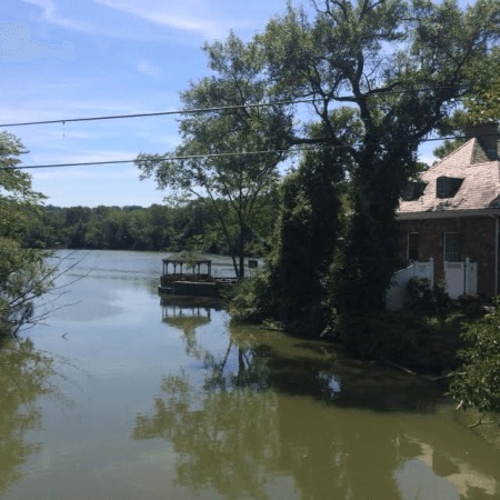
A block to the north of the Marine Corps League and across Victory Boulevard, the stream emerges from its underground culvert and widens into Clove Lake, the largest of the three lakes in Clove Lakes Park. In the 19th century, the lake was used as an ice harvesting and skating site. The lake was formed by a mill dam constructed in 1825 by Abraham Britton.
Appearing distant in the photo above is The Stone House, a catering facility built on an island in Clove Lake that also offers paddleboat and rowboat rentals.
A hidden tributary

On the day of my visit, an Urban Park Ranger was conducting fishing lessons on the eastern embankment of Clove Lake. From this vantage point, one wouldn’t know that these participants are standing atop at buried tributary of Clove Brook that flows out of Silver Lake Park.

looking at this fishing group from the island in the lake, we see a culvert that carries this hidden tributary. Prior to the park’s development in the 1930s, this tributary freely flowed from Silver Lake to Clove Lake. Today, a parking lot partially covers this brook.

Back on the unnamed island in Clove Lake, two stone bridges connect it to the mainland. Their design is reminiscent of Gapstow Bridge in Central Park. It’s an island inside a lake inside Staten Island.

For geography trivia buffs, the most extreme example of an island in an island is on Victoria (Kitlineq) Island in the Canadian arctic, which has a lake inside it with an island that has a lake inside it with an island.
Martling Dam


Continuing downstream, Clove Lake is impounded by a dam, transformed back into a brook that widens again as Martling Lake, which abuts St. Peter’s Cemetery to its northwest. The island’s oldest Catholic Cemetery, it accepted its first burials in 1848. In its first century, most of its dead were Irish immigrants, including those fleeing the Irish Potato Famine in the cemetery’s first decade. Above, Martling Dam carries Martling Avenue above Clove Brook. On one side of the dam is a picturesque lake and on the other side is a greenish pool that flows into a ravine.
Bathing by the Dam
In the years following the completion of the Martling Dam, postcards showed that the now-murky pool at the bottom of the dam was a popular swimming spot, as was the lake side of the dam.
Unfortunately today, there are no freshwater beaches within New York City parks. The only freshwater pond beach in the city is Brady’s Pond on Staten Island, but it’s a private pond. Swimming in park lakes is absolutely prohibited.
Independent island borough

Of particular interest is the dedication plaque on this dam which mentions the Borough President, but not the city’s mayor. Quite a rarity for a public works project that hints at the independent (and sometimes secession-minded) identity of Staten Island.

Clove Brook continues north from here flowing into Brooks Lake and then underground once it leaves the park (above at Forest Avenue). It merges with Palmer’s Run and then empties into the Kill Van Kull at Port Richmond.

Ahhh, you’ve taken me back to my childhood! Fond memories ❤
LikeLike
Any info on the depth of the various lakes?
LikeLike