Photo of the Week

This week’s selected photo is a 1939 Percy Loomis Sperr product from the NYPL Digital Collections. It is an inlet of Newtown creek awash in logs. Welcome to Whale Creek.

whale creek 1.JPG

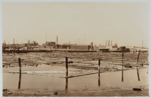
From the scene above, it may as well be the Pacific Northwest but the logs come from a region across the border from the country’s northeasternmost state. Continue reading

Vale of Cashmere, Brooklyn

In the knob and kettle terrain of Brooklyn’s Prospect Park, there is a natural valley sculpted by glaciers that was transformed by the park’s designers into a miniature Eden with reflecting pools and gardens.

cashmere postcard.jpg

It was named after a valley in Kashmir, the mountainous region straddling the India-Pakistan border. After decades of neglect, this section of Prospect Park is receiving renewed attention with a restoration project underway. Continue reading

Jackson’s Mill Pond, Queens

Throughout the past four centuries in New York, when there wasn’t enough land available for development, land reclamation extended the city’s shoreline often for ports that connected the city with the world. The same can be said for the city’s airports, which were also built on reclaimed land. In the process not only were marshlands covered, but in East Elmhurst a millpond dating to colonial times was filled following the construction of LaGuardia Airport.

jackson 1.JPG

In this 1929 photo from the NYPL collection, the shot looks east where Jackson’s Mill Pond empties into Flushing Bay. The bluff on the right is in the neighborhood of East Elmhurst while the mudflat on the left is a forgotten place known as North Beach. Continue reading

Aquacade, Queens

In advance of my upcoming public walking tour of Flushing Meadows on May 8, here’s a World’s Fair attraction that faced Meadow Lake, a stadium torn down in April 1996. From my childhood, I remember it as a ruin.

cade 3

In the above photo from Queens Chronicle columnist Ron Marzlock, the seats haven’t been finished yet as the park prepared for the 1939-1940 New York World’s Fair. Continue reading

Ayalon River, Tel Aviv

Every major city has its river and even in arid climates one can find seasonal waterways flowing between buildings and beneath the streets. In Israel’s largest and most populated city, the Ayalon River lends its name to a highway. Motorists traveling on it do not see the stream encased in concrete in its middle. Train passengers hardly take note of it.

ayalon 1.JPG

During the brief winter rains however, the river has on occasion overflowed its banks, paralyzing the highway and railway that have trapped it in a culvert. A rare example of open space in a tight city, its future is the subject of a fierce debate among planners.

Continue reading

Photo of the Week

After a week of exclusive Queens coverage ahead of my King Manor Museum author talk, we return to Manhattan ahead of an important anniversary in Central Park.

yacht 1

This week’s photo was taken between 1910 and 1915 by Bain News Service and retrieved from the Library of Congress photo collection. I am sharing it because on April 23, the Central Park Model Yacht Club is celebrating its 100th anniversary. Continue reading

Cow Kill Pond, Queens

Having written about it earlier, I mentioned that Maple Grove Cemetery in Kew Gardens had a Sunnyside Plot on the north side of Queens Boulevard that was acquired by the city in 1934 for a park and the Van Wyck Expressway route. On an old map of the cemetery this plot had an unnamed pond at its northeastern corner.

maple gr 1891

Prolific Queens history author Carl Ballenas tells me that it did have a name, based on an 1878 letter to a newspaper editor. Continue reading

Bergen Basin, Queens

Continuing on the southeast Queens theme, here’s another hidden waterway visible to countless airplane passengers but nearly inaccessible on the ground to the public.

bergen 1.JPG

Flanking the western edge of JFK International Airport, Bergen Basin has been used mainly for fuel deliveries to the airport’s massive tank farm. Prior to the construction of the airport, the highly polluted basin was an inlet of Jamaica Bay, site to a fishing community long forgotten. Continue reading

Twin Ponds, Queens

In preparation for my upcoming lecture at King Manor Museum on April 17, here’s another hidden southeast Queens waterway. Twin Ponds today are hidden behind thick vegetation along a shoulder of the Belt Parkway in the Laurelton neighborhood.

twins 4

Prior to 1954 when the parkway was widened, the ponds were a popular ice skating venue, and prior to that they supplied water to the residents of eastern Queens and Brooklyn. Continue reading

Rochdale Daylighting

In southeast Queens there is an apartment complex named Rochdale Village. When in doubt on the namesake, I look to England to find a place of the same name. The borough of Rochdale is in the county of Greater Manchester, a historic town dating back a thousand years that had the River Roch (pronounced and sometimes spelled as roach) running through its center.

roch card.jpg

Between 1905 and the 1928, the section of the river running past the Town Hall was covered, along with the medieval bridges that cross the stream. Until recently, the only way to see their arches was with a flashlight, but now the stream is about to make its return to the city center. Continue reading