Newtown Barge Park, Brooklyn

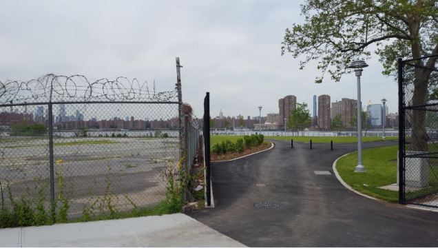
In my search for new post-millennial waterfront parks in New York, Newtown Barge Park offers a dramatic example of a landscape transformed. It lies on a formerly industrial site where the Newtown Creek flows into the East River, the watery tripoint where the borders of Brooklyn, Manhattan, and Queens meet.

park border.jpg

At the park’s main entrance, we see the stark contrast between a parking lot and the recently planted lawn that faces Manhattan’s Waterside Plaza.

Continue reading

Last word on Mussel Island

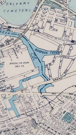
musselmap.jpgWhile visiting a Parks work shop this morning, I found a 1988 Hagstrom map hanging on the wall with Mussel Island, Newtown Creek’s phantom island making its appearance. Also on the map, Hagstrom’s Maspeth office, the now-abandoned stations on the LIRR Montauk Line, the now-defunct Brooklyn Union Gas Company…

Towards the bottom of the map is the now-forgotten Evergreen Branch, a freight rail line running along the Brooklyn-Queens border.

No one ever lived on Mussel Island, it was a small and marshy piece of land at the confluence of Maspeth Creek and Newtown Creek.

Some Hagstrom Maps put the phantom island entirely within Brooklyn waters while other maps have the island shared by the two boroughs.

Divided Phantom Island
hag bk.jpg

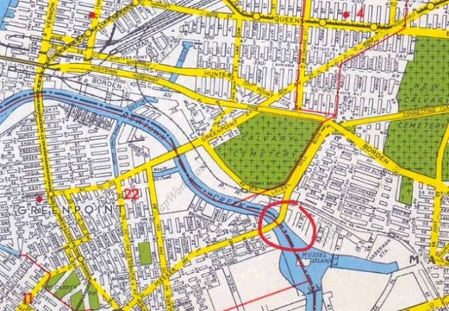
Relying on aerial surveys of Mussel Island from the 1920s, the island is in the middle of the stream, giving both boroughs a claim for it, but older maps show it as outside of Brooklyn. With the island’s disappearance, the borough border line appeared on most maps in the middle of Newtown Creek, where Mussel Island once was. When the island went from real to phantom, Hagstrom had it divided between the boroughs, as in the 1949 map above. Circled is Kosciuszko Bridge, the highest crossing above the stream.

Was Hagstrom Correct?
mus air.JPG

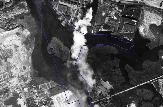
Relying on the DoITT CityMap that blends the present shorelines with a 1924 aerial survey, we see Mussel Island almost entirely within the present-day waters, with a tiny portion on what is now Brooklyn land. Back in 1924, the island was closer to Queens, and with 19th century maps as a reference, when it existed this island belonged to Queens.

Founded in 1916, Hagstrom was once the go-to authority for maps of the city and nearby cities. With the advent of GPS and satellite surveys, hand-drawn maps became obsolete. Hagstrom closed its Midtown Manhattan map shop in 2010, and was acquired by the Kappa Publishing Group that same year. Without Hagstrom, there is no Mussel Island.
Furman Island, Queens

When taking the Grand Street Bridge across Newtown Creek, one notices the avenue narrowing to two lanes as it uses a century-old swing drawbridge to cross Newtown Creek. Not known to travelers today is that this creek used to have two islands in it at its confluence with Maspeth Creek.

maspeth 2013

Nothing remains of the smaller Mussel Island, while the larger Furman Island has been fused to Queens. The former island is almost entirely industrial in use, with the exception of a small green piece of shoreline at a dead of 58th Road at 47th Street, where Maspeth Avenue once crossed over Newtown Creek. Continue reading

Photo of the Week

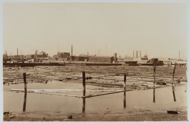
This week’s selected photo is a 1939 Percy Loomis Sperr product from the NYPL Digital Collections. It is an inlet of Newtown creek awash in logs. Welcome to Whale Creek.

whale creek 1.JPG

From the scene above, it may as well be the Pacific Northwest but the logs come from a region across the border from the country’s northeasternmost state. Continue reading

The City’s Unbuilt Canals

As today is the day of April fools, I would like to share two outlandish proposals that would have dramatically affected the landscape of Queens.

Jamaica-Bay-Flushing-Canal-NYC-That-Never-Was

Imagine a canal running on the route of Van Wyck Expressway connecting Flushing Meadows with Jamaica Bay. Continue reading

Hello From the Other Side… of the River

You may have noticed that in yesterday’s post, the hyperlink for River Lea, the forgotten stream in London, England, links to a song by top-selling vocalist Adele.

river lea

She represents a long tradition of artists inspired by hidden urban streams. Here in New York City, there are two streams that appear in poetry which I would like to share, along with a few recent examples. Continue reading

For Your Hidden Waters Bookshelf

When the authors of The Other Islands of New York City offered acknowledgements to other authors who touched on the same topic, their caption read, “No Author is an Island.” Matching their pun with the city’s urban streams, I would offer the following “tributaries.” These are books on individual waterways which I used as sources and inspirations for my book, which covers all of the city’s hidden streams.

stream book 3

The above book by photographer Anthony Hamboussi is one of many that traveled along the course of Newtown Creek, documenting the industrial waterway on the Brooklyn-Queens border. Continue reading