In my search for new post-millennial waterfront parks in New York, Newtown Barge Park offers a dramatic example of a landscape transformed. It lies on a formerly industrial site where the Newtown Creek flows into the East River, the watery tripoint where the borders of Brooklyn, Manhattan, and Queens meet.
At the park’s main entrance, we see the stark contrast between a parking lot and the recently planted lawn that faces Manhattan’s Waterside Plaza.
Where It Is

The park is located at the triangular tip intersection of Commercial and Dupont streets on the northwestern corner of the Greenpoint neighborhood. The recently-completed park features an artificial turf sports field, lawn, and shoreline walkway. The field was acquired by the city in 20142 for parks purposes, while the lawn was added in the past decade, connecting the park to the water’s edge. Its name is taken from a barge terminal located on the shoreline when Greenpoint was an industrial hub.
As it Was

Looking at the 1924 aerial survey from the DoITT NYCity Map, we see the tip of Hunter’s Point and the Greenpoint side of Newtown Creek lined with barges. The tip of land on the Queens side of Newtown Creek is today’s Hunters Point South Park, an example of resiliency in waterfront parks.

On the 1951 aerial survey there are fewer barges seen, and storage yards have replaced the factories and warehouses along the water’s edge. The triangular Greenpoint Playground and the baseball field of Newtown Barge Park are seen here, two small parks that will be expanded and reconstructed in this century.

In this 1965 aerial shot from the Municipal Archives we see the baseball field at the end of Commercial Street and a bus depot in the foreground on the right. This site will later be designated as Box Street Park. On the Manhattan side of East River is the massive Stuyvesant Town housing development, built in the 1940s to replace the former Gashouse District. As one can see in this 1965 aerial, there is no public access to the Brooklyn waterfront. There was not a single park on the East River side of Brooklyn north of Bay Ridge, and today I’ve nearly lost count of all the new parks, which I will list below.

As recently as 2012, Newtown Barge Park was an uninspiring paved sports field separated from the water’s edge by privately-owned land used for storage. Behind the park’s fence is the Manhattan skyline, without seeing the waterway that separates it from Brooklyn.
Expansion of the Park

The park’s expansion and transformation is the result of rezoning by the city in 2006 that designated formerly industrial blocks along the shoreline for high-rise residences, with a provision for public space and access to the water. Similarly to how Brooklyn Bridge Park came with luxury condos, and Riverside South came with dozens of Trump-sponsored towers, the same is happening here. Next to Newtown Barge Park is the Greenpoint Landing development.

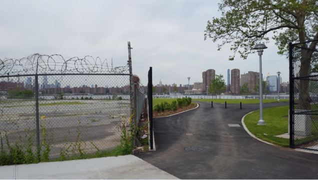
On the water’s edge the park’s walkway resembles that of East River Park on the opposite shore and nearby Domino Park a mile to the south. One cannot touch the water or launch boats in the park. Resiliency solutions offer many options for park shorelines: the rocky riprap, a beach, wetland, and a walkway elevated above the concrete and rocks below.
Blue Slip

On the lot adjacent to the park on its east side is Greenpoint Landing, a 30-story rental tower with 439 units overlooking the confluence of Newtown Creek and East River. The first tower is surrounded by landscaping designed by James Corner Field Operations, which also has the High Line and Domino Park in its portfolio. One surprise here is a new street added to the map that runs from Commercial Street and ends near the water’s edge.

Blue Slip is really an old-new street seen above as a planned road on the 1898 Hugo Ullitz atlas of Brooklyn, along with Bay, Pink, Bell, Shawnet, Pequod, and Ranton streets. Kevin Walsh has the full list of Greenpoint’s unbuilt streets. None of these were ever completed. The earliest map showing Blue Street that I’ve found is the 1855 Matthew Perris atlas. And while Blue is named as a Slip rather than a Street, it represents more than 160 years between when it was envisioned by planner and when it became reality!
That’s even longer than the Second Avenue Subway, which was planned in 1920, and had its groundbreaking in 1972. Its first three stations opened to the public on January 1, 2017.

The privately-operated park at the tip of Blue Slip is connected to Newtown Barge Park. It offers a view of the tip of Hunter’s Point, where a school and apartments towers are under construction. Newtown Creek here isn’t really a stream anymore. It is a tidal inlet of the East River, flowing at sea level for the entirely of its present-day course.
Box Street Park

At the intersection of Box and Commercial Streets, the bus depot from the above 1965 aerial photo will soon be transformed into a park that will have a dog run, basketball court, garden, picnic grove, lawn on a hill and shoreline walkway. Box Street Park went through a few redesigns that responded to public concerns before the final version was released. The park is part of the larger city plan for a series of connected shoreline parks in Greenpoint.
Further upstream on the Brooklyn side of Newtown Creek are Manhattan Avenue Street End Park, and Newtown Creek Nature Walk. As neighborhoods continue their transformation from manufacturing to residential, there will be more parks in the near future on this long-neglected waterway. Each NYC waterway has its expert specialist. When it comes to Newtown Creek, my top source is Mitch Waxman of Newtown Pentacle.
Learn More:
If you liked this essay, then take a look at my previous examples of waterfront parks and streams in western Brooklyn: Bushwick Inlet, Domino Park, and Wallabout Bay. you can also travel upstream on Newtown Creek and learn about the mysterious Mussel Island and Furman Creek.
In the News:
Daily Trust reports on the history of the Farset River in Belfast.
The Telegraph reports on the disappearing branches of the Ganges River on the India-Bangladesh border.
WABE reports on the underground section of the Flint River in Atlanta.
Arizona Daily Star reports on the revival project for a section of Santa Cruz River in Tucson.

One thought on “Newtown Barge Park, Brooklyn”