As you may know, much of my research for Hidden Waters of New York City does not involve paddling, swimming, or walking away from my desk. It involves having a grasp of GIS: geographic information systems where one compares maps of the same location to determine what lies beneath the surface. Even when the internet is down and there is no time to take the bus to the New York Public Library, I have an excellent resource down the hall from my desk at the Parks Department headquarters.

The topographical map above is undated. Taking a closer look at what’s there and what’s not there helps narrow down the approximate time of its publication and take stock of the changes on the city’s landscape since this map appeared.
Northern Queens

Looking at the northern shore of Queens between North Brother Island and Whitestone Bridge, there are a few things missing: Rikers Island Bridge, Shea Stadium, and the runways of LaGuardia Airport are not yet blocking Rikers Island Channel. What we have here that’s now gone are Jackson Creek Basin inside the airport (center), Mill Creek flowing past Flushing Airport (far right), and a broken red line along Astoria Boulevard marking the never-built Astoria Expressway.
Eastern Queens

Here’s a breakthrough clue: the Long Island Expressway only extends as far as Alley Pond Park. It continues further east as Nassau Boulevard and Powerhouse Road. The Douglaston Park Golf Course doesn’t exist yet, at this time it’s still a private country club and appears at the center of this map as a white undeveloped space. Although the boring street grid has entirely consumed Floral Park and Glen Oaks, there’s still plenty of undeveloped space along Alley Creek and Gabler’s Creek, allowing for parkland epxansion and preservation. Just across the city line is Lake Success, a kettle lake inside a golf course.
Southern Queens

The airport on this map is the New York International Airport (Idlewild Field). It would be renamed after President Kennedy in December 1963. At the northwest tip is Jamaica Racetrack, where horses ran until 1959. It was redeveloped as Rochdale Village. Although most of the Idlewild marshes were absorbed by the airport by 1948, there is plenty of swamp marked on this map, fed by the waters of Springfield Park, Brookville Park, Hook Creek, and from across the county line, Valley Stream and Mott’s Creek. Rockaway Boulevard cuts through the marshland as it still does today.
Central Queens

The major clues for dating this map appear in the heart of Queens where I live. My home is to the immediate right of Queens College at the center of the map. In 1951, the former Pomonok Country Club was developed as Pomonok Houses and the Electchester Co-op. On the southeast corner we see Saint John’s University, which broke ground on the former Hillcrest Golf Club in 1954. Flushing Creek flowed freely through Flushing Meadows-Corona Park before being partially buried for the 1964 World’s Fair. Likewise, the extension of Van Wyck Expressway along the park’s eastern edge would not happen until 1961, which is why we see the Queens Botanical Garden still occupying land within the park on the bank of Flushing Creek.
Eastern Bronx

Moving north to Throgs Neck in the Bronx, we see another area that was a latecomer to urbanization. The most conspicuous missing element here is Throgs Neck Bridge and all the highways connecting to it, which did not open until 1961. Here we see a couple of obscure waterways, Hammond Creek and Weir Creek, which had their headwaters covered by development after the bridge’s completion, reducing the creeks to coves along the shoreline.
Ferry Point Park is a flat expanse comprising of landfill atop what used to be Baxter Creek. It will remain vacant until 2014, when the Trump Golf Links at Ferry Point would open to the public. A final obscure feature worth pointing out is Stepping Stones Light, a tiny rock in Long Island Sound topped by a lighthouse.
The Narrows

As the Verraz(z)ano-Narrows Bridge would not open until 1964, the strait connecting Upper New York Bay to Lower New York Bay is clear and features a forgotten island, Fort Lafayette which was demolished to make way for the bridge. The Brooklyn-Queens Expressway was built to connect to this bridge, cutting through the street grid, separating the neighborhood of Bay Ridge from the rest of Brooklyn.
Arrows on this map indicate some of the hidden waters: Clifton Lake, Visitation Academy pond, Poly Prep ponds, and the water trap at Dyker Beach Park Golf Course. Along with Fort Lafayette, The Narrows is guarded by Fort Wadsworth on Staten Island and Fort Hamilton in Brooklyn. Only Fort Hamilton is still an active military base today.
Central Staten Island
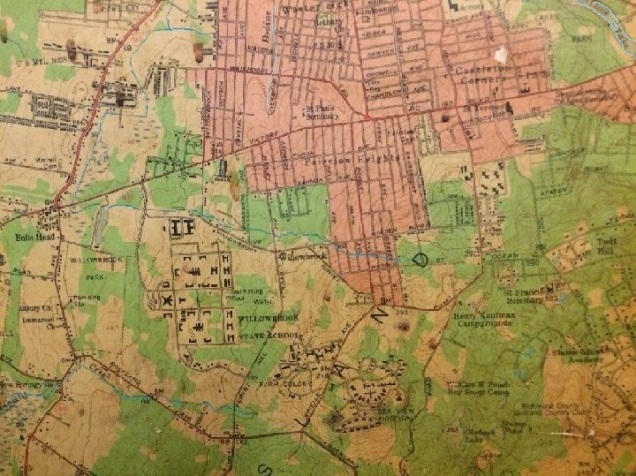
Willow Brook flows freely towards the west, past the troubled Willowbrook State School, into Willowbrook Park. Along Rockland Avenue, Springville Creek flows from its source on the grounds of the Farm Colony west towards Fresh Kills. Along the ridge that includes Todt Hill are numerous campgrounds pocked with kettle ponds.
As this landscape predates the Verrazano-Narrows Bridge, there is no Staten Island Expressway and the ancient Victory Boulevard serves as the island’s main east-west route. It was important enough to merit a New York State Route designation, NY-439.
Seeing N. Y. S. and U. S. route signs within the city makes me feel like I’m in a small town. Within NYC’s borders, you are more likely to see interstate signs.
Tottenville

The southernmost neighborhood in New York City (and state) is Tottenville, where Arthur Kill and Raritan River flow into Raritan Bay, across from Perth Amboy, New Jersey. Seeing so much greenery on this map, Tottenville residents had to travel through nearly three miles of undeveloped land before reaching the next neighborhood to the east, Great Kills. Most of this green space is not parkland. It is forest, as opposed to the white spaces that are grassland and wetlands. Among the isolated communities in these woods are Rossville and Sandy Ground, built in the 1830s by former slaves.
Arrows on the map indicate some of the local hidden waterways: Mill Creek, Lemon Creek, Wolfe’s Pond, Arbutus Lake, Sweet Brook, and Richmond Creek. The southernmost corner of the city is still the least developed today, though there are many more homes on the map, along with the West Shore Expressway and Richmond Parkway.
Securing the Date: The map offers two more tantalizing clues that help to narrow down its publication date: Ebbets Field in Brooklyn is still standing while Manhattan’s Third Avenue El is not on the map. The last trains above Third Avenue ran on May 12, 1955, while Ebbets Field hosted its final game on September 17, 1957. It was demolished in 1960. Let’s also recall that the Long Island Expressway did not reach the city line until 1958. That puts the map between 1955 and 1957.
The Moses Photo
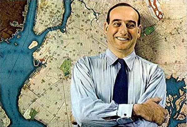
The most iconic Parks Commissioner is Robert Moses, who led the agency from 1934 to 1960. Above is a photo of Moses in 1938, posing in front of a city map. This is not the same map as the one in my office’s hallway, but it’s pretty close in appearance and size.
Later this week I will recreate Moses’ pose in front of the late 1950s map. Follow me on Twitter to see the recreated pose.

5 thoughts on “Mid-Century GIS”