When I am not getting my shoes wet by exploring streams, I look carefully at old maps and aerials in search of where the hidden waterways once flowed in the open. Last week, I conducted a park inspection in the far-off Travis neighborhood of Staten Island, where the Parks Department has a plant nursery.

The plant nursery is a former farm, and on one of its walls is a 1968 reproduction of Charles W. Leng’s 1896 Map of Staten Island with Ye Olde Names & Nicknames by William T. Davis. There is so much information on it relating to the island borough’s history. Let’s zoom in on a few details.
Staten Island’s Center

To make the map easier to understand, I highlighted two roadways on the map, Victory Boulevard and Bradley Avenue. The latter was recently featured on this blog as it crosses over Willow Brook. The former is an ancient roadway that stretches east-west across the island, historically known as the Richmond and Philadelphia Turnpike.
At its eastern tip, ferries connected to Brooklyn and Manhattan; while at its western end, a ferry connected to Woodbridge, where the road continued westward to Philadelphia. Prior to the construction of the Staten Island Expressway and the Verrazano Narrows Bridge, Victory Boulevard was one of the most important roads on Staten Island.
Of note topographically is Todt Hill, near the northwest corner of this map. The highest point on the island, its slopes are the starting points for some of Staten Island’s better known waterways.
On its southern side, Reed’s Basket Willow Swamp, Mersereau’s Valley Brook and Moravian Brook emerge, combining further downstream to form New Creek. On the northern slope, Clove Brook emerges, widening into Clove Lakes on its way north. To the west, Willow Brook emerges at a spot called Willow Dale, while a tributary of Palmer’s Run called Stinking Brook flows out of a spot called Centreville.
Southern Tip
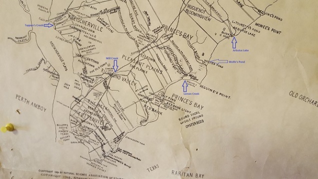
At the island’s southern tip, Leng clearly notes the courses of ponds and creeks that have since been preserved within the Bluebelt system and some of the local parks, including Arbutus Lake, Wolfe’s Pond, Lemon Creek, and Mill Creek. The waterways that I’ve never seen before on maps which appear here include: Tappen’s Creek, which flowed out from the clay pit ponds westward towards Arthur Kill; Elliot’s Pond in Tottenville; and Butler’s Creek on the site of the Mount Loretto preserve.
Up North
In contrast to the largely Republican orientation of the borough, the island’s North Shore has a long history as a Democratic stronghold. This section of the island is the closest to Manhattan and was urbanized long before the bridge to Brooklyn was built. Up here, Leng depicts Harbor Brook, which flows through the campus of Snug Harbor. This stream included a tributary, Logan’s Spring Brook.

The map identifies the springs that had unique names. Nearly all of them have since been covered by development. While the main branch of Harbor Brook flows largely undisturbed through Goodhue Pond and Allison Pond on its way north, Logan’s Spring Brook has largely disappeared from the surface. Except in one spot.

A block to the east of the Snug Harbor campus is the one block Wales Place, which is interrupted midblock by a brook. It flows out of a culvert for a few yards of daylight and then disappears again. This brook reemerges on the Snug Harbor property where it meets Harbor Brook. Below is Logan’s Spring Brook flowing on the Snug Harbor campus, looking west from Kissel Avenue.

There is so much vegetation covering the stream that the best chance of seeing it clearly is in winter.
About Charles W. Leng

Charles W. Leng (1859-1941) was a prolific researcher, historian, and educator who accompanied William T. Davis (above left) on his travels across Staten Island. together they documented the island borough’s culture, history, and geography. His collected writings are on file at the Staten Island Museum.
In the News:
DNAinfo reports on the upcoming transformation of Ennis Playground in Gowanus, Brooklyn.
National Geographic reports on extreme swimmer Christopher Swain’s swim in the Gowanus Canal as part of an effort to raise awareness of its water quality.
Gothamist reports on artist Joe Reginella’s prank monument relating to the Staten Island Ferry.
Pittsburgh Post-Gazette reports on the proposed daylighting of Negley Run as a solution for flooding on Washington Boulevard.
CBC reports on the proposal to daylight a section of Sawmill River in Dartmouth, Nova Scotia.

Hello Mr. Kadinsky,
I found my way to your very interesting blog from Forgotten New York and have been really enjoying your carefully researched and well written entries. Can’t wait to pick up the book.
Like you, I’m very interested in the history and natural history of waterways, pretty much everywhere, but especially around the NY metro area. I wonder if you would be interested in turning your investigative talents to what may once have been a small stream or probably perched water feature in my neighborhood of Jamaica Estates?
Shortly after moving into the neighborhood (NYC tax map block 9962, bounded by Henley Road, Chevy Chase Street, Barrington Street, Chelsea Street & 87th Road); which sits right on the south facing slope of the terminal moraine above Hillside Avenue, several long time residents mentioned that there used to be a small “stream” running through the backyards in the center of the block. One neighbor, who grew up on this block in the 1930s – 1940s, described the “stream” as well as some of the wildlife she regularly observed in the area, including quail and cottontail rabbits.This of course interested me and got me exploring the area. I quickly noticed what looks like a public water supply well or similar public water works on the west side of Chevy Chase Street between Henley Road and 87th Road. This site currently has NYCDEP public water sampling stations on the sidewalk outside the fence line and I wonder if this used to be infrastructure of the old Jamaica Water Company? A well once used to pull water out of the ground at this site makes me wonder if the groundwater elevation was once very close to or even at the ground surface here, which would have allowed for the formation of a pond, seep or similar feature. Whether this was some type of localized, perched groundwater condition resulting from a layer/s of clay or other impervious sediment from the moraine, or actually the upper glacial aquifer is an interesting question.
It would be great if you could look into this area for one of your future posts. One additional, interesting observation: a good deal of what looks like the native forest vegetation was retained when this block was developed. Throughout the rear yards of the homes on this block, grow several huge Tulip trees, very large oaks and understory tree species such as dogwoods and hickory. There is a remnant of the climax forest of the moraine managing to survive here.
Congratulations on a fascinating book and blog!
LikeLiked by 1 person