The largest park in the South Bronx has an Olmstedian terrain of hills, outcroppings, fields and woods. What is missing at St. Mary’s Park is a water feature. Considering the park’s age (1888) and size (35 acres), the question is raised whether it had a pond in the past.

The 1934 Praeger aerial survey of the park from the Municipal Archives, shows a ridge running down its midpoint and gentle slopes on either side. The park was about to be transformed by Robert Moses who added playgrounds and sports fields to it. But then there is the flat area on its western side, at St. Ann’s Avenue and E. 147th Street.
Where it Flowed

The oldest map that I’ve found bearing the park’s name is from 1865, when the surrounding area was the Town of Morrisania. On the far left is Mill Brook flowing along the future Brook Avenue. The railroad track running diagonally here is the Port Morris Branch, which remained active until 1999. The ponds near the tracks emptied into Bungay’s Creek, which ran to the East River. Clearly visible within the park is a “fish pond” in the flat area at St. Ann’s Avenue and E. 147th Street. This section of present-day Mott Haven was then known as North New York.
The park was a private property open to local residents. On its hilltops were five mansions, the most prominent being Janes’ Hill, where iron manufacturer Adrian Janes had his home. This hilltop shares its namesake with a much taller Jaynes’ Hill that is the highest point on Long Island.
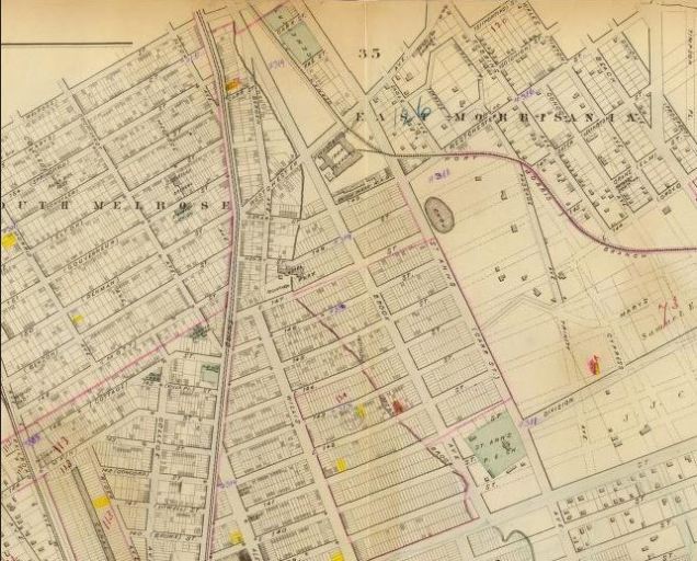
Morrisania was annexed to New York City in 1874 following a referendum. City planners quickly drafted a plan to extend Manhattan’s street grid north into the Bronx. On this 1879 map, we see dotted lines on the park and its pond, but no lot subdivisions.

One should thank journalist John Mullally for preserving the park and its pond. With the annexation of western Bronx, he recognized the urban future that would conquer the farms and manors of Morrisania and Fordham.
His efforts resulted in the preservation of St. Mary’s Park as public land. Note that his description of the park has “wood and water” hinting of this fish pond.
His name appears on the map a mile to the west of here on the former course of Cromwell’s Creek that is Mullally Park.
Where’s the Pond?

When the first citywide aerial survey was conducted in 1924, the fish pond was gone, a grassy field now taking its place. By then the Port Morris Branch that skirted the park’s western border was driven underground. The surrounding neighborhoods were almost entirely filled with multi-unit apartments housing families who migrated here from Manhattan using the elevated railroad lines and subway.

Like many parks that were former estates, St. Mary’s Park retained Janes’ mansion as an office and supply storage. In this 1913 postcard, it did not have as much architectural flair as Litchfield Villa in Prospect Park, the much older Van Cortlandt mansion, or the more lavish Bartow-Pell mansion in Pelham Bay Park. The mansion was demolished in 1934, in the decade when Robert Moses was transforming many of Olmsted’s passive recreational parks for active recreation.

The 1942 map of St. Mary’s Park shows an oval near the train tunnel, perhaps for an outdoor theater. On the site of the pond we see a field house and another oval marked as “wading pool.” Such pools took up little land and were relatively inexpensive to maintain. As far as I know, this was the only prewar Parks pool built exactly on the site of a natural pond, through Fisher Pool in Queens also comes close. The postwar Lasker Pool in Central Park also stands atop a natural waterway.

The oval-shaped pool in the 1942 map is not an accurate depiction. As we see in this 1941 Municipal Archives photo of St. Mary’s Park West Playground, it was a rectangular basin splashed by eight jets. Hardly a pool, certainly not a pond.
Return of the Water Feature
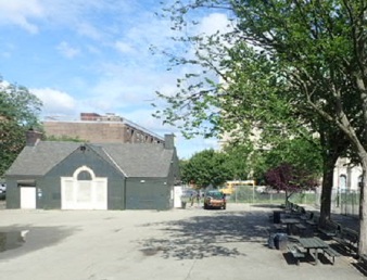
The field house for this wading pool still stands today facing St. Ann’s Avenue, its interior used for restrooms and storage. It has enough space to serve as a classroom or pre-school, should the city decide on such uses.
The site of the wading pool is covered by solid pavement in this 2018 photo. I am not sure when the wading pool fell out of favor with the park’s management. Perhaps there were safety concerns, or destruction in the years when the Bronx was burning.

In this century, specifically the year 2019, the asphalt facing the field house was torn up and the playground was given a makeover. New benches, play equipment, and fountains on a blue circle splashing water on the exact site of the historic fish pond. It’s not a stream daylighting, being more akin to Jackson Pond Playground in Queens, where a decorative fountain and paving hint at a long-gone waterway.
The Pool that Wasn’t Built

In 1951 the city proposed the first full-service recreation center in the Bronx, to be located on the southwest corner of St. Mary’s Park. Designed by the firm of Brown, Lawford, and Forbes, the modernist facility visually clashes as much with its host park as Lasker Pool does with Central Park. Although this rec center has an indoor pool, the original plan sought to include a much larger outdoor and wading pools behind the building. In reality these two items were never completed and the park’s southwest corner remains as verdant as it was when Mullally described it.
Rain Garden
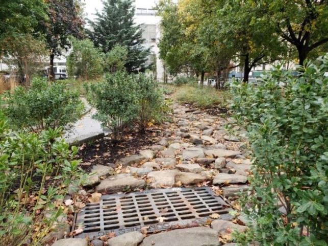
To the right of the entrance to St. Mary’s Park Rec Center is a fenced area with a constructed stream leading to a drain. This is the park’s $1.4 million rain garden, where water is collected from the rooftop in a silo-like tower and then channeled along this rocky stream bed. Along the way the flow is consumed and filtered by plants before emptying into the drain.

Together with green rooftops and bioswales, the rain garden is one more tool in Parks’ efforts to reduce the amount of storm water entering the sewer system. As the garden ends within a few yards of the playground, it raises the question whether the old fish pond could have been restored with water collected from the rec center rooftop.
Learn More:
As part of NYC Park’s Anchor Parks Initiative, the agency released a Master Plan in 2018 for the park in partnership with the firm Starr Whitehouse. Expect to see more ecologically-friendly features in this 35-acre historic green space.
In the News:
Bronx Times reports on the new dock completed at Roberto Clemente State Park on the Harlem River.
East Bay Times reports on the removal of the culvert on McCosker Creek near Oakland, Ca., restoring natural flow to this waterway.
Missoula Current reports on plans to remove the dam on Rattlesnake Creek near Missoula, Montana.
Associated Press reports on wetland restoration projects around the world.

I lived on 407 E. 137th. St. off Willis Ave. in the 1950s when I was a youngster. St. Mary’s Park was the closest park to me. My dad would take me there on the weekends, and it was a great place to play in!
LikeLike