On my childhood trips from Queens to Jones Beach, my family drove on the Meadowbrook State Parkway. The highway’s 12.5-mile route runs mostly through a thickly forested landscape before the trees give way to the salt meadows of the south shore.

The forest on the highway’s shoulders gives the impression of wilderness, but behind it are thousands of tract houses built during the 1950s suburban housing boom. Also not visible from the highway is its namesake stream, East Meadow Brook, which also shares its name with a nearby suburban community. One place where motorists can see it is at the Merrick Road cloverleaf, where it appears as a tidal inlet.Where it Flows
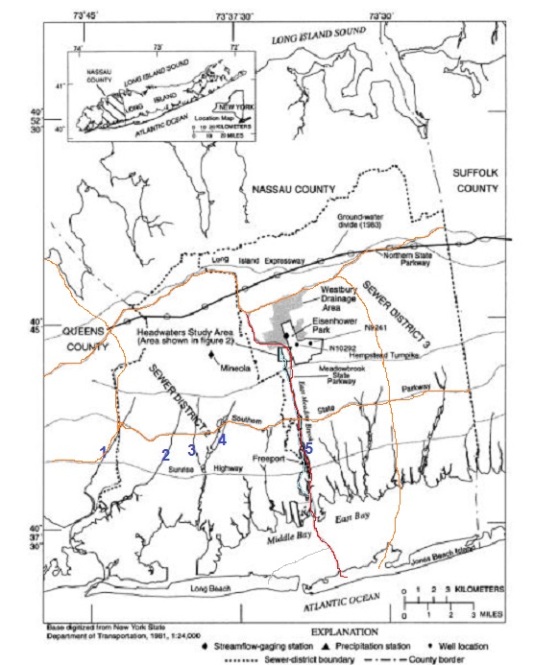
East Meadow Brook is one of many north-south streams flowing in Nassau County from its headwaters on Hempstead Plains on a gently sloping course to the bays connecting to the ocean. From west to east, I numbered Simonson Creek, Motts Creek, Pine Stream, Mill River, and East Meadow Brook. Valley Stream is too small to appear on the above map, which was published in the 1993 USGS study titled, “Urbanization and Recharge in the Vicinity of East Meadow Brook.”
In red is Meadowbrook State Parkway, which parallels the namesake stream, and in orange and the other state parkways on this county, which were all built in the same decade. The stream emerges to the surface to the south of Eisenhower Park, the largest county-operated park on Long Island.
Hempstead Plains

As seen in this 1939 aerial survey of Mitchel Field, the geographic center of Nassau County contained one of the largest prairies east of the Appalachian mountains, resulting from silt deposited in the last ice age. Hempstead Plains provided an ideal terrain for horse racing courses, early aviation, and golf courses. The image above appears in Scott M. Ecker’s book East Meadow, on the history of the community that shares its name with the stream.
It can be seen here flowing through the grounds of Meadow Brook Club, whose golf course was taken by the state in 1954 for the Meadowbrook parkway extension. The club then built its present course further to the east. The two roads seen here are Merrick Avenue and Hempstead Turnpike. The grassland in the lower right is today’s Eisenhower Park.

Very little open space remains on Hempstead Plains, with the development of Mitchel Field for the campuses of Hofstra University, Nassau Community College, and Nassau Coliseum. In Eisenhower Park, Salisbury Lake is located near the historic headwaters of East Meadow Brook. To its west across the highway is an unnamed pond that collects runoff from the road and plain, which then flows south as the brook.
Circled in orange is the printing press and office of Richner Communications, where I worked for a year in 2011. It was my first full-time newspaper job. On my lunch breaks, I explored the unused train tracks behind the office, nearby grassland, and the former air force base-turned-community college.

Glenn Curtiss Boulevard crosses Meadowbrook State Parkway with a functionalistic bridge that omits the decorative arches and stonework emblematic of this highway. The ditch to the right of the southbound lanes is where East Meadow Brook flows. The boulevard above was named after an aviation pioneer. One can learn about his connection to Hempstead Plains at the nearby Cradle of Aviation Museum.
From State Park to Parkway

As seen on the 1946 Hagstrom atlas of Nassau County, East Meadow Brook was still flowing freely then, with three farm ponds along the way. Barnum Pond was entirely filled in the 1950s for the parkway’s extension; Mullener Pond remains as it is, and Smith Pond is inside land designated for park purposes. Note that Meadowbrook Parkway begins its route at Southern State Parkway and both highways are colored green.
The reason for this was Robert Moses who simultaneously ran Long Island’s state parks and the building of parkways at the same time. Designed solely for passenger car use, these highways offered generous green shoulders and brick arch overpasses, providing the sense of driving inside a park. Along its 41-mile route, Southern State Parkway connects to Valley Stream, Hempstead Lake, Belmont Lake, and Hecksher State Parks. It also connects to parkways bound for Bethpage, Jones Beach, Captree, Robert Moses, and Sunken Meadow State Parks. Moses foresaw the suburban development of Long Island and wisely set aside land for state parks and parkways before they were snapped up by developers.

Many of the state parks along Southern Parkway are situated on streams flowing north to south, which begs the question of why East Meadow Brook did not receive its own state park? In the June 2, 1933 edition of Brooklyn Daily Eagle, we see land set aside for Meadowbrook State Park with a causeway leading to Jones Beach. The 457-acre park served as the right-of-way for the parkway, which provided a second route to Jones Beach. The two men pictured here are B. L. Van Schaick, executive secretary of the Long Island State Park Commission, and Sidney Shapiro, the engineer in charge of the project.

On this 1927 Belcher-Hyde atlas, we see three proposed State Parks in southern Nassau County: Meadowbrook, Wantagh, and Massapequa, each on streams and lands previously used to supply water to the city of Brooklyn. The proposed Meadowbrook State Park also appears in this 1939 Dolph & Stewart Atlas. But on the 1946 Hagstrom Atlas, the parkland along the highway has no name.
Meadowbrook State Parkway opened in 1934, relieving some of the congestion from the nearby Wantagh State Parkway that opened five years earlier. With the completion of Meadowbrook Parkway and attention focused on Jones Beach State Park, the designated Meadowbrook State Park was left untouched as an undeveloped forest shrouding the parkway and the namesake brook. The proposed Wantagh State Park and Massapequa State Park were relinquished to the county, which operates them as nature preserves.
County Parks on the Brook

Mullener Pond is located on the northbound side of the parkway, formed as a millpond in the early 19th century by the Mollineaux family. It is bound by Jerusalem Avenue on the north and Southern Parkway at its outflow. A quarter mile downstream from the pond, Old Mill Road also remembers the pond’s history. In the 1830s when the Mormon faith was in its infancy, the brook was used for baptisms by local Mormons.

A mile downstream in the community of Roosevelt, Smith Pond is the centerpiece of Rev. Arthur Mackey Sr. Park. He was a resident of Roosevelt, a postwar suburb that offered homes to minorities at a time when developers in other nearby suburbs insisted on selling only to white folks. The forested shoulder lands to the south of this park appear on some maps as the county-operated Roosevelt Preserve, originally mapped for the unrealized Meadowbrook State Park.
Water for NYC

On the 1914 map of southern Nassau County, the old estates are fewer in number with subdivisions taking their place. As with other south shore streams, East Meadow Brook was also dammed to provide water for Brooklyn in the late 19th century, and New York City in the early 20th century.
The conduit ran parallel to the Babylon Branch of the Long Island Railroad between Massapequa and Rosedale. The pipeline’s route is today’s Sunrise Highway in Nassau County and Conduit Avenue within New York City.
East Meadow Pond, at the bottom of this map, is far from the community of East Meadow, but it is named after its feeder stream. Water leaves this pond through two outlets: Freeport Creek to the southwest, and the continuation of East Meadow Brook to the south, where it flows past a former landfill.
Landfill to Park

To the south of Merrick Road, the parkway’s long-arm metal lampposts end their parade and the forested shoulders give way to the salt meadow as the road hops across the islands of Hempstead Bay on its way to Jones Beach.
Wooden lampposts line the road here, designed for their “scenic” and rustic appearance.
The brook here follows the parkway to the bay as a tidal inlet. On its left side is a manmade mound that is the south shore’s counterpart to Brooklyn’s Shirley Chisholm State Park, and Staten Island’s Brookfield Park. The 52-acre Norman J. Levy Park and Preserve lies atop the decommissioned Merrick Landfill, a former trash dump transformed into a park. At 115 feet, its highest point, one can see the Manhattan skyline, Jones Beach water tower and amphitheater, and the open ocean beyond. Its namesake was a longtime State Senator who championed the seatbelt law. Fittingly Meadowbrook Parkway is co-named for Levy.
 The park has a rural agricultural look with a farm-style windmill that circulates water to its two hilltop ponds. These are freshwater bodies surrounded by saltwater, akin to the ponds of Broad Channel. As a result it has become an attractive stop for migratory birds. On its slopes is a resident herd of working goats, tasked with keeping the grass short.
East Meadow Brook is accessible to kayakers here, with maps at the kayak launches showing this park as part of the South Shore Blueway, a set of designated kayak routes on the south shore lagoons of Nassau County, connected by public docks with views of the many hidden waterways that feed into these lagoons. Within Nassau County, one can take a kayak into the tidal sections of Mill River, Parsonage Creek, Millburn Creek, Cedar Swamp Creek, Newbridge Creek, Bellmore Creek (which follows Wantagh State Parkway), Cedar Creek, Seamans Creek, Massapequa Creek, and Carman Creek. Upon reaching the heads of the inlets, one can then explore further upstream by foot. When I retire, I can certainly move out there, get a boat, explore these hidden suburban streams, and work on Hidden Waters of Nassau County.
Learn More:
for the history of Long Island’s parkways, expressways, and highways, my go-to source is Steve Anderson’s NYC Roads. No website is as encyclopedic in detail as his when it comes to local limited-access roads, including those that were never built,
In the News:
Queens Courier reports on the reopening of the waterfront walkway in Hermon McNeil Park in College Point, Queens.
Bronx Times provides an update on plans to transform the former Pelham Bay Landfill into a park.

Right above the words “Hempstead Plain” on the illustrated aerial view there’s a small section of an old Mitchel Field runway and taxiway visible. That section was the filming location for an iconic movie scene, namely Sonny Corleone’s spot o’ bother at the tollbooth.
Peter
LikeLike
All interesting info for us locals . The meadow brook was a really nice place before the parkway came through.
LikeLike