The largest park on the east side of the East River is Astoria Park, located between the Triboro (RFK) and Hell Gate bridges. It has the largest outdoor pool in the city but shortly after the park was created, there was a highly unrealistic plan to give this park a bathing beach. Under the noise of the two bridges, the public can swim, use the running tack, tennis courts, playground, and lawn, among other amenities.
Until recently, the park’s relationship to the East River was overshadowed by the massive pool and Shore Road that runs along the water’s edge. With the pedestrianization of this road, the public has easier access to the shoreline where the turbulent current of Hell Gate can be observed.
Where It Is

On the city DOT map of the Queens Waterfront Greenway, I circled the waterfront parks between Hunters Point and Lawrence Point. Most of this greenway runs on a separated bike lane on Vernon Boulevard, deviating from that road where there are waterfront parks. I circled the waterfront parks of Queens on the East River, where Astoria Park is the largest among these parks.

The shoreline here is narrow and rocky. The stream here is deep with a fast-moving current that terrified ships for the past 400 years. The removal of dozens of rocks near Hallets Point made navigating easier at Hell Gate, but still not smooth. Perhaps that’s why as other parks recently has boat ramps installed, at Astoria Park there are no plans to alter the seawall. Hell Gate Bridge frames the top of this photo. Completed in 1916, it was the first bridge connecting Long Island to the mainland, carrying passenger trains to Penn Station and freight trains to Brooklyn. Inside its anchorage towers are stairs that rise to a walkway on the bridge. I don’t expect them to be open to the public, but perhaps annually as an Open House New York experience.

On this 1852 Matthew Dripps map from the Library of Congress, I highlighted Hoyt Avenue and Ditmars Boulevard that frame the park. Near Hoyt Avenue was hidden waterway, Linden Brook that flowed for three blocks towards Pot Cove. The descendants of Hoyt and Ditmars can take pride that their names remain on the map today.

Beach at Astoria Park?

From the Municipal Archives there is a plan by landscape architect Carl F. Pilat from 1914, the years after this park was acquired by the city. The feature that’s there today is the running track on the southern side and the tracks on the northern side. Pilaf’s plan also included tennis courts, a monument, playground, and most astonishing- a bathing beach. I cannot imagine how safe it would be to swim at Hell Gate unless a sizable cove were carved out of the shoreline to shelter swimmers from the current. There are today parks with beaches on the East River, but these beaches are for collecting shells, sitting on the sand, launching kayaks, but absolutely no swimming!


Looking at postcards from the early years of this park, Shore Boulevard retained its slightly curved route from the time when it was used as an access road to the Hoyt, Woolsey, and Barclay estates. Each had a mansion overlooking the river in the 19th century, when Astoria was a fashionable suburb of Manhattan. As the neighborhood’s population grew, so did the call for a park and in 1913 the city designated the three properties as Gaynor Park, in memory of William J. Gaynor, who died that year.
The name failed to catch on and Astoria Park became the official name. Politicians love to rename streets, bridges, and parks after their colleagues but in many cases, the public refuses to go along. A more recent example is Triboro Bridge which was renamed in 2008 in honor of Robert F. Kennedy, but few New Yorkers call it the RFK Bridge, despite all the official maps. As for Gaynor, he’s not entirely forgotten. There’s a monument built in his honor at Cadman Plaza Park and a middle school with his name in Brooklyn. He is best-remembered for surviving an assassin’s bullet.

The urbanized look of Astoria Park began with Shore Boulevard, which was given a seawall in 1927. At the time, nearly all waterfront parks were given walls on he water’s edge to protect the shoreline from eroding. From an ecological viewpoint, seawalls prevent wildlife on land from accessing the water and as waves crash against the concrete, these walls eventually crumble. In this century, riprap, beaches, elevated walkways, and restored salt marsh are the preferred designs for waterfront parks. The power plant in the background here is at Stony Point in the Bronx, which I documented earlier. Behind the bridge on the Manhattan side was Little Hell Gate, an inlet that separated Wards and Randalls islands.
Living in the Park

In the shadow of the Hell Gate Bridge the Barclay mansion stood inside the park and perhaps in a more appreciative generation, it could have been preserved as a park office, community center, or recreation center. When Astoria Park was acquired in 1913, the mansion was described in very harsh terms as crumbling, decrepit, and worthy of demolition. Many waterfront parks were built on former estates of the wealthy. So while the mayor’s official residence is Gracie Mansion in Carl Schurz Park, the mansions of Hermon A. MacNeil Park, John Golden Park, Faber Park, Fort Tryon Park, St. Mary’s Park, and Von Briesen Park, are distant memories preserved in photographs.


In the middle of the park there was a smaller residence that survived into the 1920s. From the NYPL collection, this structure was described as a “small cottage” without any further details. A more detailed cottage nearby is listed as the former gardener of the Woolsey estate. It also was demolished before the massive swimming pool was built. In contrast, Fort Tryon Park in upper Manhattan lost its mansion but retained its gardener’s cottage as an office.
Prior to the Pool

In 1934, the Parks Department conducted an aerial survey of its properties and the shot of Astoria Park is among the last taken before the swimming pool and Triboro Bridge greatly altered its landscape. At the time, the running track was on the site of the pool and it would later be relocated to the south side of the park in line with Pilat’s plan. There is a body of water inside the park that functioned as a wading pool and ice skating rink. Older maps of the site, particularly the 1851 survey of Hell Gate show a small pond on the site of the wading pool.
A flagpole stands on a high point in the southern end of the park and it is still there today. Under construction is the Queens anchorage tower of Triboro Bridge and to its right a set of homes that were condemned for the highway approach to the bridge. Land under the ramp would be added to Astoria Park. To the north of the anchorage is the cottage, which would shortly be demolished as the bridge was being built. The factory opposite the middle of the park was initially a silk manufacturer and then an electric products company. I could imagine the factory workers taking a dip in the park’s pool during their breaks. Like many former factories, it is today a luxury residence.
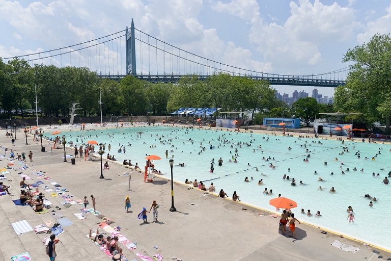
The Astoria Pool

How quickly the pool was built! It was the Great Depression and in infusion of federal funding gave the unemployed workers a mission of beautifying the city’s parks. Under the leadership of Commissioner Robert Moses, more than a dozen pools were built across the city with Astoria as its crown jewel. It opened on July 4th, 1936 and was used for training by the Olympic team. I’d tell you more about its history, but the Bowery Boys have a detailed essay, so why reinvent the wheel?

Among the superlatives of Astoria Pool was the city’s tallest diving platform with jumps at 5, 7.5, and 10 meters. It also had two smaller diving platforms on the sides. Safety concerns forced the diving pool to close in 1980 and since then it has stood as a rusting monument to more exciting times here. The semicircular diving pool became a swamp as water collected at its bottom. Rather than restore the diving area as it was, the city is reconstructing it as an outdoor performance space. The pool crater was filled, and the platform was preserved.
For more on the park’s history, see the city’s archeological survey from 2017, and landmarks report from 2006.

As Shore Boulevard is now entirely car-free, I look up and think of additional roads that could be restored to pedestrians and bikes. On the Triboro Bridge (No disrespect meant, but I refuse to call it the RFK) the walkway on the north side is open, but not accessible to wheelchairs, while the south walkway remains closed, despite its million dollar views of Manhattan. The city and state should reopen it as a second option to the public. Recently, Brooklyn Bridge was given separate routes for pedestrians and bikes. The same can be done on the bridge.
Ralph DeMarco Park

To the north Ditmars Boulevard there is an extension of Astoria Park that was added to the park in 1968. The extension was named for local resident Ralph DeMarco, who championed transforming the unused 1,750 feet of shoreline here into a park. The terrain isn’t entirely natural. Some of the fill here originated from the construction of the 63rd Street subway tunnel two miles to the south.

In 2012, Hurricane Sandy pummeled the shoreline here, which does not have a seawall. The city had it restored to its previous appearance. Across the water, one can see Randalls Island and Bronx Kill, the tiny inlet that separates that island from The Bronx.

DeMarco Park ends abruptly at 20th Avenue, where the Astoria power plant occupies Lawrence Point and the bend in the East River where it widens and turns east. There have been discussions on closing this power plant and redeveloping it with public access to its shoreline, but it likely won’t happen in this generation. To function, every city needs space for utilities and infrastructure, such as garages, trash transfer stations, bus depots, railyards, among other things. Not every empty parcel should be a park, school, or residence. Even if this power plant closes, this sizable parcel could serve the city in other ways that keep the city running. Turning east of this power plant are Luyster Creek and Bowery Bay, which I documented on Forgotten-NY a few years ago.
Every park deserves a citizens group to support its upkeep and promote public events. Astoria Park Alliance is the city’s partner in the largest waterfront park in western Queens.

Sergey, when did Paerdegat Creek (aka Paerdegat Brook, Bestevaar Kill, and Bedford Creek) disappear? It had connected the old Paerdegat Pond (in located in the old Paerdegat Woods, which you wrote was “the last ‘old time’ forest in Brooklyn”) to Paerdegat Inlet. It probably disappeared gradually between the 1920s and 1940s. I grew up in the Glenwood Houses in the 1950s. Much of the land around the housing project was swampy. You know a lot about the subject. I thought you could tell me about the disappearance of the creek. The pond probably disappeared owing to sedimentation.
Thanks. BTW, your book is terrific.
LikeLike
The statement, “Completed in 1916, it was the first bridge connecting Long Island to the mainland, carrying passenger trains to Penn Station and freight trains to Brooklyn” is not correct. The Brooklyn, Manhattan, and Williamsburg Bridges all came long before 1916; the Williamsburg opening in 1903, the Manhattan in 1909. Also, Manhattan is certainly not “the mainland”—only the Bronx is.
LikeLike
I realize that if you had separated the sentence into two parts, it would have been clearer. You should have stated, “Completed in 1916, it was the first bridge connecting Long Island to the mainland. From the Bronx, it could take passenger trains to Penn Station and freight trains to Brooklyn.”
LikeLike