As a Parks analyst, I’ve researched the history of hundreds of parks throughout New York, but when is a “park” not a park? When it appears in Borough Park, Rego Park, Ozone Park, and Rockaway Park– all neighborhood names that ironically do not have have large parks within their borders. Then there’s Jerome Park, a horse racecourse from a century ago that had been submerged in favor a drinking water reservoir in the northwest section of the Bronx.

As it is with the park-name neighborhoods, there are no large parks around the shore of Jerome Park Reservoir. The small green spaces that are there are separated from the water by a double fence.
Where the Horses Ran
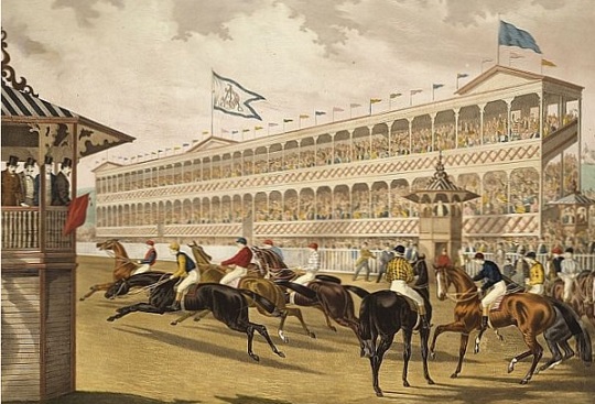
Forerly the countryside home of Alexander Bathgate, the 230-acre hilltop property was purchased and opened as a racetrack on September 25, 1866 by Leonard W. Jerome. A successful stock speculator, this “king of Wall Street” had a passion for horse racing. Together with August Belmont Sr, he organized the first Belmont Stakes at Jerome Park in 1867. At the time, the property was within the Village of Fordham, Westchester County. The course also hosted the Champagne Stakes, Ladies Handicap, and the first polo match in the country in 1876. Jerome’s socialite daughter Jennie married into British aristocracy and is the mother of Sir Winston Churchill.
On the Map

On the above 1872 Beers Atlas map of the area, we see Jerome Park on the left with its unusual “saddlebags” course. St. John’s College on the bottom is today’s Fordham University. The Fordham Park development to its north never made it off the map, a likely victim of the financial Panic of 1873. That year, western Bronx was annexed by New York City. The site later became the New York Botanical Garden.
The creek originating at the top center of the map is School Brook (today’s Mosholu Parkway) flowing into Mill Brook alongside the railroad tracks of today’s Metro North Harlem Line. The Cromwell Farm development takes its name from a colonial family that owned land in present-day western Bronx. Their name also appeared on the now-buried Cromwell’s Creek where Yankee Stadium stands today.
Concerning streets on this map: Jerome Avenue runs along the edge of the racetrack, remembering its founder to this day. Southern Boulevard is also seen here. Mosholu Parkway and Grand Concourse have not yet been conceived. As the city’s population grew, so did its need for water. On October 4, 1894, the Jerome Park Racetrack was closed in favor of a reservoir. Reporting on the occasion, the New York Times described the park as the “nursery of American racing.”
The Reservoir as Envisioned

As I often point out, some of New York’s most famous sites are unfinished (case in point: Second Avenue Subway). The Jerome Park Reservoir is another example. On the Aqueduct Commissioners’ plan above, the reservoir was designed to cover nearly the entire property of Jerome Park in two basins.
 The Jerome Park Reservoir was intended to hold two trillion gallons of water. When it was completed, it stored enough water to quench the thirst of Manhattan and the Bronx for ten days. During its construction, Division Engineer Daniel Ulrich compared his task to the pyramids of Egypt.
The May 12, 1906 edition of Scientific American heaped praise on the reservoir, but while the 94-acre west basin sparked with water, the site of the larger eastern basin remained as a massive construction pit. It was within this unbuilt basin that the racetrack had been. Beneath the reservoir ran the underground tubes of the original Croton Aqueduct and the successor aqueduct line that tapped water from the Catskill Mountains further upstate.
Acropolis of the Bronx
As it is with Columbia University, Yeshiva University, and City College of New York (my alma mater) there is something attractive about having a college campus on a hilltop overlooking the city. Planners felt that it evoked the Acropolis of ancient Athens, while students hiked the slopes with heavy backpacks on their way to class.

For the Boogie Down Borough, that hilltop is Jerome Park Reservoir, where Lehman College sits atop the site of the unbuilt east basin. In a late hurrah for the Collegiate Gothic style, this public works project proposed nine buildings for the campus, but by 1931 only four were completed. Yet another unfinished New York destination.
 Prior to the college’s construction, part of the East Basin was developed in 1917 as a rail yard for the Lexington Avenue subway line, a branch of which runs nearby on elevated tracks above Jerome Avenue.
The remainder of the East Basin remained empty until 1927, when Joseph V. McKee, president of the city’s Board of Aldermen proposed to use the land for civic projects including an uptown campus for Hunter College and a privately funded Museum of the Peaceful Arts. The former became reality, while the latter was never heard from again. The uptown campus was formally dedicated as Lehman College on March 28, 1969, the 91st anniversary of namesake Governor Herbert H. Lehman’s birth
To the north of Lehman College is the elite but public and tuition-free Bronx High School of Science, which moved to its present campus in March 1959. The final academic element at Jerome Park is DeWitt Clinton High School. Originally based in Manhattan, its present facility opened in 1929. It was an all-boys public school until 1983.
Access to the Reservoir
With the development of neighborhoods around the reservoir, there have been calls for decades to make its shoreline more accessible to the public as a running path similar to the one around Central Park Reservoir. The city’s answer had been a rejection based on security grounds for the last reservoir on the aqueduct before the water emerges from the people’s faucets.
Small openings are finally showing at Jerome Park Reservoir. In 2015, the city’s Department of Environmental Protection announced a pilot program to open the waterway’s perimeter to the public for a few hours on one weekend for admiring the reservoir. It did so again in November 2016.
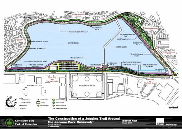
Keeping the possibility of a public jogging path for Jerome Park Reservoir, the PArks Department commissioned the landscape architecture firm MKW+Associates to design a master plan for the site, which appears above. It would give the “marathon men” of the Bronx their own reservoir to run around.
Between the streets and the fences ringing the reservoir there are a few small parks within the space: Fort Independence Park, Old Fort No. 4 Park, Jerome Park, and Harris Park. So if asked whether there is a park today called Jerome Park, it is the 4.359-acre strip of grass on the reservoir’s eastern bank, but the name often refers to the entire reservoir and sometimes the neighborhood around it.

The reservoir and its peripheral parks is a link in the Aqueduct Walk, a series of parks situated atop the route of the Old Croton Aqueduct. Following the water’s path from Jerome Park Reservoir towards Manhattan, follow Reservoir Avenue to Kingsbridge Road. Across this road, the Aqueduct Walk becomes a linear park that extends south as a narrow parcel for 1.5 miles. For nearly another mile, follow University Avenue to High Bridge, which leads into Manhattan. The history, maintenance, and tours of the aqueduct route is being promoted by the nonprofit Friends of the Old Croton Trail. As as linear parks go, Aqueduct Walk is not as sexy as Manhattan’s High Line, but is longer, older, and certainly less crowded. (photo above courtesy of Forgotten-NY)
Tracey Towers
Looking north from the reservoir, the most recognizable structure in sight are the Tracey Towers. The tallest buildings in the borough, these twins are 38 and 41 storeys in height. Designed by architect Paul Rudolph and completed in 1974, they are a “vertical city” intended to provide for many of their residents’ needs without having to leave the towers.
Jerome Park Without the Water
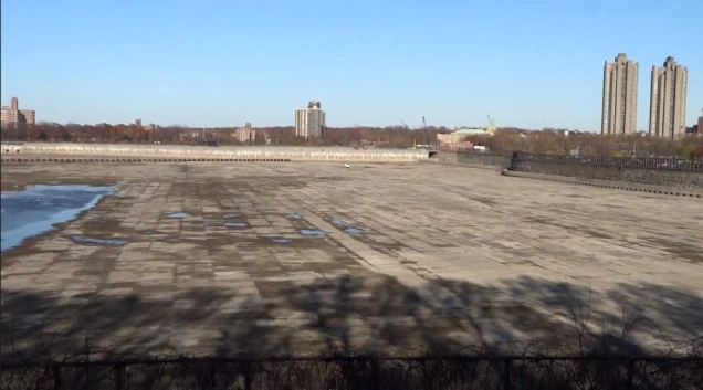
In 2008, the Jerome Park Reservoir was emptied in connection with the building of the nearby Croton Water Filtration Plant, exposing its flat concrete bottom. It would have been a good opportunity to bring back horses to the site. The plant was initially slated to be built within the reservoir, but local opposition moved its location a mile to the north, beneath Van Cortlandt Park. It was an unusual scene for local residents who have been used to seeing an inland sea from their windows for nearly a century. Water was restored to the reservoir in 2011.
Two local civic groups, Friends of Jerome Park Reservoir and the Jerome Park Conservancy, have been active in having historically significant sections of the reservoir designated, such as its gatehouses; and ensuring expanded public access to this vital piece of the city’s infrastructure. Perhaps in a not-so-distant future this reservoir will become as obsolete as its predecessors in Bryant Park and Central Park. At that point the options will be either to develop the site as a park or to leave the water as it is. I have a feeling that the latter option will be chosen, as it had been with Central Park’s great reservoir.

Interesting history. In my youth, I lived on Jerome Avenue at 166th Street.
LikeLike
Saw this reservoir from my fifth floor windows on University Avenue.
It will always be part of my childhood.
Carole Culver
LikeLike
Thank you. Please share the book and blog with your friends.
LikeLike
As a kid me and a friend walked half way across it one winter when it was frozen over. Nuts!
LikeLike