In the years prior to the Second World War, my grandfather lived in Bucharest where he worked at his uncle’s workshop. In contrast to his humble hometown, the Romanian capital aspired to be the Paris of Eastern Europe with its wide boulevards, triumphal arch, majestic palaces, and an urban waterway lined with trees and benches.

In the postcard above, found on a local history blog, we see the Dâmbovița River flowing straight through the city, with neatly planted trees on either bank. In the corner is a postage stamp featuring the country’s boy-king Mihai (Michael), who first sat on his throne at age five. The river has seen plenty of changes in its host city since the founding of the country.
Where it Flows
The river originates on the slopes of the Carpathian Mountains. Although it flows through the country’s most important city, it is not a navigable river, nor does it reach the sea. It flows into the Argeș River, which in turn flows into the mighty Danube that takes its water to the Black Sea. In the Middle Ages, the river flowed with plenty of oxbow turns past the garrison settlement first mentioned under its name in 1459.
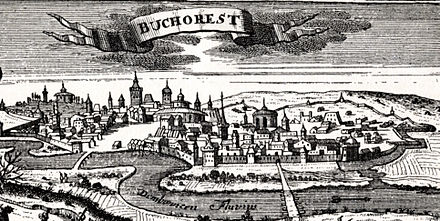 On this 1717 woodcut of the city, the Dâmbovița is seen flowing on the city’s south. At the time, it was the capital of Wallachia, a vassal state of the Ottoman Empire. The principality lay at the front lines of the Austrian, Ottoman, and Russian empires, subject to wars and the whims of the regional powers. It was notable regional market, with a diverse population and maze of tight streets within its walls.
Building a Country, Taming a River
In the mid-19th century, nationalism was sweeping across eastern Europe from Finland to Greece as ethnic minorities demanded greater autonomy and outright independence from the empires that ruled the continent. Wallachia united with Moldavia into a unified principality as a first step towards the Romanian nation-state. As Bucharest developed, the occasional flooding of the Dâmbovița River was becoming less tolerable.

Above, Prince Alexandru Ioan Cuza and Dr. Carol Davila are shown personally visaiting the flooded Tabaci district, in an 1864 Theodor Aman illustration. Prince Alexandru ordered milldams on the river removed and approved plans to straighten its course into a manageable canal. Although Cuza was overthrown in favor of Prince Carol I in 1866, the work continued until completion in 1880.
Fine Art on the Dâmbovița
As a newly formed nation, Romania strove to compete with older nations on the continent by selecting a respected royal family, raising an army, and classically-inspired architecture, it also invited a polymath artist to depict the country in paintings. That artist was the Malta-born Amedeo Preziosi, whom Carol I met on a visit to Istanbul shortly after his coronation. The prince invited Preziosi to Romania, where he created nearly 250 oil paintings, watercolors and sketches of portraits and landscapes. Preziosi captured the Dâmbovița as it was about to be transformed into a managed channel.

One scene has nude women bathing in the river, a scene difficult to imagine considering the proximity of horses to them, and by then the river already had a reputation for pollution from the runoff flowing into it. The church steeples in the background remind viewers that this was Bucharest. Preziosi is associated with the romanticism genre, which depicted idealized scenery in art.


Preziosi spoke Maltese, Italian, English, French, Greek, Turkish, and Romanian. He lived most of his life in Istanbul, attracted by its east-meet-west ambiance, an ideal setting for orientalist romanticist scenes in art.
Transforming the Course
In 1878, Romania’s independence from Turkey became official. Under Carol I, Bucharest was envisioned as the Paris of Eastern Europe with lengthy boulevards slashing through the medieval maze in the same way that Baron Haussmann had done for Paris under Napoleon III. In the following century, the changes that the Bucharest had witnessed would have made it nearly unrecognizable to Cuza.

On the 1853 and 2013 comparison above, other than the river, only the institutions of the Romanian Orthodox Church can be seen on both maps. They are the Antim monastery, St. Anthony’s Church, and the Patriarchal Cathedral, the seat of the national church. Everything else on the map, including the river had been altered by Cuza, the Hohenzollern dynasty, and the communist regimes. In particular, communist dictator Nicolae Ceausescu, who ruled from 1965 until his overthrow in 1989. Inspired by his 1971 visit to Pyongyang, he razed nearly a quarter of the city in his last ruling decade. His monuments are gone, but not the Union Boulevard and the Palace of the Parliament.
My Grandfather’s Bucharest

My grandfather was born in the province of Bessarabia, which Romania controlled between the world wars. At age 14, the impoverished lad took a train to the capital in search of work. The above photo was taken in 1927, seven years before his arrival in the city. By then, the Dâmbovița was lined by boulevards along its banks from one end of the city to the other.

In many places, wide bridges and plazas hid the river beneath them. It was never a navigable stream, so it offered no practical benefits for the city, as its planners thought at the time. Below is a 1938 view of a bridge constructed on the river.

It was an uncertain time in the city as fascist gangs roamed its streets as Europe was heading towards another world war. One of the positive memories he had of that time was King Michael’s birthday, when anyone who was born on the same day as him was entitled to a free drink. Although he was born a month before the king, he felt a relation to him as they were the same age. Both men’s lives were later disrupted by the war and the subsequent imposition of communism.
The River Today
The most detailed source on the history and current conditions of the Dâmbovița River can be found in the Ecological Society of America‘s open access journal, a peer-reviewed publication. In its November 2016 edition, authors Liliana Zaharia, Gabriela Ioana-Toroimac, Octavian Cocoş, Florin Adrian Ghiţă, and Emanuel Mailat, examine the Dâmbovița River in Bucharest. The article features a detailed map comparing the natural course of the river with its present channel.

It also has fascinating before and after photos of places along the river in the city showing how unrecognizable today’s Bucharest would appear for Prince Alexandru Cuza.

Along the Way
 The urban section of the Dâmbovița begins at Lacul Moriii (Mill Lake), a reservoir completed in 1986 that was designed to hold back the spring floods coming down the river from its snow melt sources in the Carpathian Mountains. The lake is used for a variety of sports and recreational activities, an inland sea for a city that is three hours by train from the Black Sea port of Constanta.


 On a similar note, I’ve wondered for a long time what ever happened to King Michael after he was forced to flee the country in 1947. He returned in 1989 to a crowd of supporters but was too humble to ask for the crown. He lives as an influential public citizen. Like many former monarchs, he has suggested that if the public wills it, he will accept the crown again.
In the News:
Brooklyn Daily Eagle visits the hidden waterfront neighborhood of Georgetown in Brooklyn.
New York Times examines some of the unusual destinations along Brooklyn’s Gowanus Canal, such as an indoor shuffleboard court.
Bronx Times reports on the proposed development of the rail yard on the Bronx Kill at the southern tip of the borough. A place that can accurately be described by KRS-One as the South South Bronx.
New Yorker reports on the condition of Mosul Dam in Iraq and the danger that its rupture could cause to that country.
New Yorker also covers the topic of dams with a report on wildlife on the restored Elwha River in Washington.

7 thoughts on “Dâmbovița River, Bucharest”