As mentioned before, many of the city’s expressways and parkways were built atop or alongside waterways as their shorelines were usually undeveloped and less steep than the surrounding landscapes. The parkway is a New York institution, pioneered by Olmsted as a road lined with generous parkland on either side, shielding neighborhoods from traffic, creating green space for local residents, and a visually pleasant setting for travelers.

Mosholu Parkway‘s name is believed to originate from the Lenape term for “smooth stones” in reference to a stream. Did a brook ever flow on the path of this parkway?
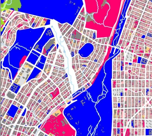
Hints on an Old Map
According to historical signs posted by the Parks Department, Mosholu was the native name for nearby Tibbett’s Brook, a stream that runs through Van Cortlandt Park. The sign indicates that there was another stream running on Middlebrook Road. Bronx Historian Robert McNamara wrote that this stream was called “Schuil Brook” and its name later was anglicized to “School Brook.” Its Dutch name is identical to the Schuylkill River in Phildelphia, which translates as “hidden creek.” The ancient Middlebrook Road that followed it was absorbed into Mosholu Parkway in 1884, the year that this creek was buried.
The slides above are from the “Topographical map made from surveys by the commissioners of the Department of Public Parks of the city of New York of that part of Westchester County adjacent to the City and County of New York embraced in Chapter 534 of Laws of 1871 as amended by Chapter 878 of Laws of 1872.” Published soon after New York City annexed western Bronx from Westchester County, it outlines the complex topography of the future borough, as well as the proposed streets and parkways that would eventually march across the terrain.
Mosholu Parkway was envisioned as a link between Van Cortlant Park and Bronx Park. Further east, Pelham Parkway connects Bronx Park and Pelham Bay Park. A third example, Crotona Parkway connects Bronx Park with Crotona Park. So while The Bronx is regarded as the most urbanized of boroughs, this belt of green space enables travelers to cross the borough east-west without leaving a park.
A More Recent Map

In 2013, the Wildlife Conservation Society released a study of the West Bronx that documents the forgotten waterways of the borough. School Brook is clearly visible on the map, flowing in the same southeast direction as the route of Mosholu Parkway. At the present-day intersection of the parkway with Webster Avenue, there was a wetland, where some of its water drained into the Bronx River, while the rest flowed south as Mill Brook.
Looking at some of the old maps contained in the Archaeological Documentary Study for 186 St. George’s Crescent, School Brook appears to be the headwaters of Mill Brook, completely separate from the Bronx River watershed. The report found that near the source of School Creek was Negro Fort, a little-known Revolutionary War redoubt manned by African-American soldiers, former slaves from Virginia who fought for the British. School Brook supplied water for this fort.
What’s There Today
When traveling along Mosholu Parkway, it’s hard to detect that a stream once flowed on the route. One has to find dips in the terrain and compare them to old maps. One possible location of School Brook is at Marion Avenue, which runs on an elevated embankment between the parkway’s southbound service road and its express lanes.
In an unintended pun on Mosholu’s name, railing posts along Marion Avenue feature smooth stones embedded in the cement.
A Possible Restoration?
In the Wildlife Conservation Society report, one map mashes present-day structures, zoning categories and former waterways. As seen above, the white-colored median and shoulder space along Mosholu Parkway can accommodate a small watercourse. It could serve a purpose as a bioswale, absorbing runoff from the road, channeling it into a constructed wetland and emptying into a nearby waterway.
Learn More:
The measure of a neighborhood’s appreciation of its parkland is a dedicated advocacy group. Since 2013, Friends of Mosholu Parkland have led this cause, volunteering on tree planting, cleanup, and gardening along the one-mile boulevard section of the parkway.

Thank you for writing this article. As a core member of Friends of Mosholu Parkland, I’ve learned even more about the beautiful parkland that we continue to help preserve and conserve for now and hopefully forever.
LikeLike
Would you happen to know the management of the historic landscape on a local level? On October 17th at 7:15 pm at the Community Board 7 office on 229 East 204th street, PARKS will be presenting options for the Mosholu malls because they want to uproot all the dogwood trees that was planted between Van Cortland Est and Hull Ave/Marion Ave on Mosholu Parkway because someone or 2 complained that the landscape on Mosholu is historic and therefore nothing should be planted on historic landscape. Is that documented anywhere? And why can’t trees be planted on historic landscape for conservation and preservation of the land?
LikeLike
First time I’ve read about this dispute. Unless Mosholu is a designated scenic landmark as we have with Ocean Parkway and Eastern Parkway, its landscape can be altered.
LikeLike
Dogwoods were saved with the help of many community residents and are actively been taken cared for with weeding, composting and watering. Though we are still curious about the watercourse you mention. We had a mental vision drawn on paper for terrain #14 on Mosholu (east mosholu parkway south between Marion Ave and Webster Ave) AKA The Gully- of a fenced in pond with natural wildlife due to the deep topography of this particular terrain. Also right off of this area is Frisch Field and several times had to fill in large cave-in’s on the ground. I’m assuming there is running water underneath moving soil.
LikeLike
The community should be aware there are two naturally occurring rare Pumpkin Ash trees on Mosholu Parkway between Bainbridge and Marion/Hull Avenues. The Pumpkin Ash (Fraxinus profunda) is a globally endangered species. The trees are either male or female and we are fortunate that on this site, we have both a male and a female tree. These trees, which occur in swamps and wetlands, are undoubtedly a remnant of the former watercourse. As globally endangered and historic remnant trees, they should be given the highest conservation priority possible.
LikeLike
Thanks! will look for it. Say hi to your NYBG colleague Dante Burgos for me.
LikeLike
Between Bainbridge and Marion/Hull on which side? FOMP can keep an eye on them and also provide tree care when needed. Hull is on the Mosholu North and Marion on the South. There has been a few trees that were taken down due to storms and health. We had one huge one go down on it’s own just a few months ago. I did check to see what the tree looks like — it’s leaves etc.. I can’t find it. You said there were 2 of them.
LikeLike