Here’s my first essay on an urban stream in sub-Saharan Africa. In Luanda, the Angolan capital, there’s Rio Seco, or “dry river,” which is barely visible as it flows behind buildings as an open sewer on its way to the ocean.

In the second half of the last century, Angolans first fought a brutal war of independence and then a civil war between the Marxist government and anti-communist guerillas. These days the country is prospering from oil and diamonds. The obelisk on the right marks the tomb of Agostinho Neto, Angola’s first president. Luanda is sprawling, but its urban streams remain neglected.
Where it Flows

I couldn’t find detailed maps of Luanda online, as the stream is quite obscure. Nevertheless, one local organization, Building Society for Architecture has an aerial survey showing Rio Seco in its present state and a proposed “intervention” from 2017 that would widen its banks as a continuous park.

The source of Rio Seco appears near the Zona Verde (green zone) in the Maianga neighborhood, to the south of the city center. The street grids here date back to at least the 1950s when Portuguese colonial authorities envisioned a planned metropolis radiating out from the old city. While the streets appear in order, architecture here is a mix ranging from makeshift to upscale that includes foreign embassies. The struggle for independence that brought the Marxist MPLA government to power in 1975 was closely supported by Cuba, which explains the green zone’s official name: Jose Marti Park, after the 19th century Cuban patriot.
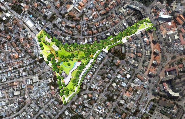
There are plans to develop Zona Verde into a park but for now the site remain vacant. As it is envisioned, the park could contain a visitors center, trails, basketball courts, and a stream. It does not appear to have a connection to Rio Seco.

On its concrete-clad course through Maianga the stream has the appearance of an open sewer, its chaotic appearance mirroring the country’s situation of its first quarter century following independence. As with the Cuban-inspired park at its source, the streets crossing Rio Seco are also named after Angola’s postcolonial allies: Marien Ngouabi of Congo; Amilcar Cabral of Guinea-Bissau; and Rua dos Herois, the Street of Heroes. Although the MPLA renounced Marxism in 1992, the city still has a Lenin Street. Among other post-colonial fighters: Nrumah, Nasser, and Ho Chi Minh also appear on the map of Luanda!

Luanda is a city of contrast, with astronomically-priced upscale residences and expensive basic commodities within a short walk of sprawling shantytowns known as musseques. It is difficult to imagine that one of the world’s most expensive cities looks nothing like New York or London. In these western cities, urban waterways are undergoing restoration projects while Luanda’s waterways are jammed with trash.

The challenge of transforming Rio Seco into a linear park involves the displacement of homes along its banks, which would disrupt neighborhoods and established communities, but beneficial in the long-term as it concerns the city’s environment and quality of life. At the time of independence, only a half million people lived in the Agolan capital. Today this metropolis has 6.5 million residents, but no highways or subway lines, and only one railroad line. In 2015, the Luanda Metropolitan Master Plan by the British-based international architecture firm Broadway Malyan was approved by the government. Its radiating boulevards are reminiscent of Daniel Burnham’s plan for Chicago and the use of its urban streams as linear parks evokes the ravines of Toronto.
Previous Plans for Luanda

The Portuguese ruled coastal Angola for nearly a half millennium, leaving a deep cultural imprint n the country. Luanda was founded as a slave trading post in 1576 on the natural harbor shielded from the ocean by barrier islands. As it grew into a city, it became a showcase of colonial rule. The 1953 plan for the city features wide boulevards, a street grid and sizable parks. The Y-shaped Zona Verde appears on the bottom. To its west was a planned linear park that was to follow Rio Seco to the ocean.

One would have to squint and use a magnifier to find Rio Seco on this 1960 map. The more visible Cambamba appears to the south of the city’s airport. On the city’s eastern edge was the designated industrial zone, next to the Benguela Railway that run inland to he center of Africa. As the population grew, land between the major roads would be filled with shantytowns. This map comes from Paulo Moreira’s PhD report on the coastal neighborhood of Chicala.
Other Streams of Luanda

Some urban streams are more visible than others. One map of Luanda’s watersheds prominently shows the Cambamba, Cabolombo, and Cacuaco rivers appear prominent, but not Rio Seco. For some of these streams it is too late for natural restoration as there are too many roads, homes, and businesses built atop their courses. The Cambamba River offers the best prospects for a linear park, as there’s more open space along its course, but it will take a massive cleanup to remove trash and pollutants that have accumulated in this stream.

One thought on “Rio Seco, Luanda”