Throughout New England there are examples of urban streams that powered the industrial revolution and contributed to the development of cities. But as these streams flowed through their respective downtowns, they caused flood damage and with pollution, there were calls to have them confined to culverts and forced underground. In the state of Connecticut: Hartford has the Park River, Waterbury has its Mad River, and Meriden has Harbor Brook. Closer to New York is Danbury, where Still River has a similar history.

Once the hat making center of the country, the mills of Danbury are mostly silent and the shoreline in the city’s downtown appears as an afterthought, confined to a concrete channel as seen above at White Street.
Where it Flows
 The watershed of Still River is largely within the towns of Bethel, Brookfield, and the city of Danbury, with a tiny portion in New York state.
Within Danbury, it accepts water from Padanaram Brook and Parks Pond Brook. It continues for another 20 miles outside the city center, flowing north along Route 202 before flowing into the Housatonic River at Lover’s Leap State Park. The watershed map on the left was designed by the Housatonic Valley Association as part of its watershed management plan.
After more than two centuries of agricultural and industrial runoff, the entire Housatonic River watershed, which includes Still River is being redeveloped as a cultural and natural corridor. It could serve as a blue-green linear park for downtown Danbury, if it were more visible.

The earliest map showing Still River dates to 1776, when Connecticut joined 12 other east coast colonies in declaring independence from the British. A century earlier the site of Danbury was known to local Natives as Paquiack, or cleared land. The first Englishmen arrived in 1685, calling the area on Still River at Main Street as Swampfield. A year later the settlement was renamed after a village in Essex, England.

As Waterbury was billed as the brass capital of the country, Danbury had the largest collection of hat manufacturers. The water of Still River was dammed upstream from the city to provide water for the factories but within the city, mercury waste from hatmakers poured into the stream turning it into a health hazard. The state did not ban the use of mercury in hat making until 1937. On the 1875 map above, we see factories clustered along the stream. Near the bottom center is Starr’s Pond, a tributary of Still River that was subsequently filled.

The 1911 postcard of the Hayes Von Gal hat factory shows Still River in the foreground and railroad tracks that connect Danbury to New York. The amount of mercury in the river caused many workers and residents to suffer from erethism, also known as “mad hatter’s disease” and the “Danbury shakes.” The last hat manufacturer in Danbury closed in 1987, ending two centuries of the industry’s connection to this city. In the second half of the last century, factories were closing while Still River flowed through the city as an afterthought.

Then there was the flood of August 11-13, 1955 when Still River overflowed its banks and flooded downtown Danbury. It flooded the city again on Oct. 13-16 of that year, after another hurricane dumped excessive rain on the state. The city had enough and the Army Corps on Engineers confined the river in a deep concrete channel.

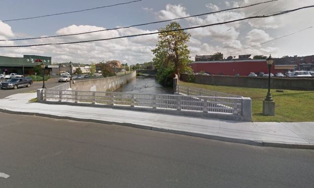
As seen at Crosby and Main Streets, there are spaces along its banks that could be re-purposed for recreational use, but this would require cooperation from private property owners. In this Google Street View, one can see that there is a historical sign on the lawn next to the stream. It is part of the city’s Museum in the Streets series. The sign here speaks about natural disasters relating to Still River.
 On the opposite side of this intersection the river is underground, hidden beneath Kennedy Park and the bus stop across Kennedy Avenue. A water-theme mural painted by the local YMCA hints at the river that flows here. The park hosts the Downtown Chow-Down, an outdoor eating event held here every Thursday during the summer in an effort to bring workers outdoors and promote tourism.
At the confluence of Padanaram Brook and Still River there is a small triangular space that could provide access to the water as a small park, but for now only the trimmed lawn and lamppost hint to its potential. The tributary stream received its name from the Puritan settlers inspired by the name Padan Aram, associated with the early biblical figure Laban.

But the concrete straitjacket imposed on Still River is not a guarantee against future flooding, as shown in a contractor’s map of the city center with 100-year and 500-year predictions putting shopping areas and the Danbury Railway Museum in harm’s way. With climate change making such floods more frequent, cities plan for resiliency in ways that respond to projections, moving development back from riverbanks, setting them aside for parks that contain wetlands instead of concrete embankments.

Downstream from the city center in the town of Brookfield, the Still River Greenway offers a vision that could one day follow the entirety of the 19-mile stream. Construction here began in 2011 and it continues to expand. The Bedoukian Bridge, named after a nearby philanthropic supporter is the defining landmark of this new linear park.
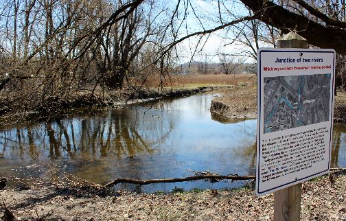
Within the Still River Greenway one can find informational signs that tell the story of the stream, such as the one above where Lime Kiln Brook flows into this river. Beyond this park Still River turns north and continues for another 10 miles. It enters Housatonic River near Lover’s Leap State Park. As with all hidden urban streams, this one has its community support group, the Still River Alliance. Its members advocate for continued cleanup of its banks, monitoring the quality of the water, and expanding public spaces along its course.
In the News:
BBC reports on the proposal in Athens to daylight the ancient Ilisos River.
Florida Times-Union reports on efforts to expand public access to St. John’s River in Jacksonville.
Popular Science reports on the impact of urban stream restoration.

Decades ago I went to a science fiction convention in Danbury called “HatCon,” and I have friends who live in Brookfield. I’ll send them a link to this fascinating local history!
LikeLike
Thank you.
LikeLike
I used to live up in Brewster NY and would always go to Danbury for a lot of things and this is some great history I did not know
LikeLike