Bordering on the campus of the College of Staten Island is a 215-acre woodland with a lake that is part of the larger set of connected parks, the Staten Island Greenbelt. Willowbrook Lake shares its name with the surrounding park and has a rustic log cabin-style boathouse that is used as the park’s office.

The lake appears natural but was carved out of the landscape after the city acquired Willowbrook Park. It is the most visible section of Willow Brook, a hidden waterway that flows across central Staten Island.
Where it Flows

The first map to show Willowbrook Lake is the 1917 G. W. Bromley atlas, where a city-owned parcel has a lake outlined in pencil. This property was acquired in 1909 from a water company. In 1929, the property was declared a park. Close to the proposed lake is Bull’s Head, a neighborhood centered around the intersection of Richmond Avenue and Victory Boulevard. Its name is derived from a colonial-period tavern located at this intersection.

A 1937 photo by Percy Loomis Sperr from the NYPL Collection shows Willow Brook following Victory Boulevard. This road is among the oldest on Staten Island. It was laid out in 1816 as Richmond Turnpike, a toll road operated by Vice President Daniel Tompkins. This eight-mile road ran from the Brooklyn and Manhattan ferries at Tompkinsville to the New Jersey ferry at Travis. Sperr also took a photo of the nearby tavern that gave the Bulls Head neighborhood its name.

The earlier 1891 Julius Bien atlas shows the full length of Willow Brook flowing west from its source at the foot of Todt Hill, along Willowbrook Road. Marked red on the map, it served as the border between the towns of Middletown and Northfield, both of which were absorbed into New York City in 1898. Bradley Avenue appears on this map, and back in 2016, I surveyed a portion of Willow Brook that runs below this road.

Shortly after the 1898 annexation, borough’s Topographical Bureau at the Board of Public Improvements drew up a map in 1901 with a proposed street grid and parks. Way ahead of its time, the plan had Willow Brook preserved within a linear park that served as a green corridor between Todt Hill and Willowbrook Park. The park on this map does not match the exact location of today’s park, but it is very close. Instead, the site of the proposed park became the campus of a military hospital in 1942 and later a notorious mental asylum. The area with the most rigid grid on this map is the undeveloped Bloomfield section, an expanse of wetland which remains mostly vacant to this day.

As mentioned earlier the park’s boathouse at the lake’s southern tip is not used for boat storage at this time. It was built after 1929, but I was not able to find the exact date. Its appearance truly has the look of the Adirondacks minus the mountain views. In this photo behind the matching informational sign is the Carousel for All Children, the park’s unique attraction designed to give disabled children a spin.
On Willow Brook

The source of water for this lake is at its northeast tip where Willow Brook is exposed to daylight. Morani Street enters the park here leading to its softball fields.

Willow Brook flows out of the lake at its northwest tip, descending through a ravine of boulders and then back into darkness beneath Victory Boulevard. The stream reemerges ot the surface at Signs Road on the northern border of the William T. Davis Wildlife Refuge. This 428-acre preserve is the city’s oldest, designated in 1928 and named after its leading advocate. Inside the preserve, the stream widens into a navigable channel and merges with Springville Creek. This tributary originates in the neighborhood of New Springville. Beyond this confluence, it carries the names Main Creek and Fresh Kills as it flows through the former Fresh Kills Landfill.

Returning upstream, between Morani Street and the park’s eastern border is a wetland that shows how Willow Brook appeared for most of its course prior to the arrival of urbanization.

On the campus of the College of Staten Island, a section of Willow Brook appears on the median of Loop Road near its north gate. In the woods on camps, the brook flows out of a pipe. Continuing upstream, it appears in short segments behind backyards and at Bradley Avenue, as mentioned earlier.
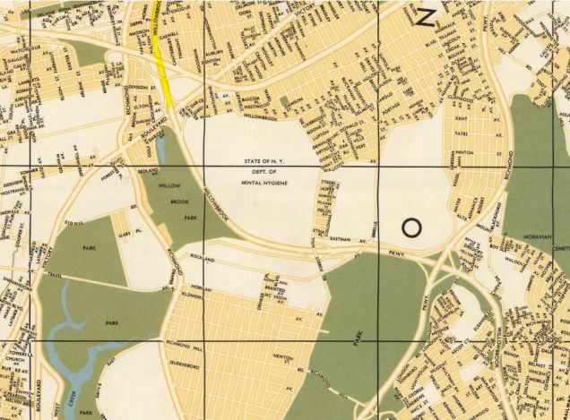
Much of this woodland was threatened between the 1930s and 1960s, when Parks Commissioner Robert Moses proposed the route of Willowbrook Parkway to run through this park on its route between Bayonne Bridge and Great Kills Park. On the 1962 Hermann Bollmann map above, the lake is enveloped by a smaller Willowbrook Park and a grid of streets that makes exceptions only for the mental hospital, cemeteries, and the Fresh Kills landfill.
In November 1964, the section between Bayonne Bridge and Victory Boulevard opened to traffic. Its abrupt end was at the northern edge of Willowbrook Park, where the highway encountered determined public opposition. The rest of its route was designated as a link in the greenbelt, with the White Trail approximating the highway’s path. The completed section of the highway was later renamed Dr. Martin Luther King Jr. Expressway.
Signs Road

The explanation behind the name of Signs Road is lost to history, but it appears here on the 1874 Beers Atlas as having a mill on Willow Brook. The wetland to the south of this road is at sea level, part of the William T. Davis Wildlife Refuge. The Winant family has roots on Statne Island dating to the colonial period. In 1884 the mill pond was sold to the Crystal Water Company. The pond was later filled in for a flower nursery. In 1957 the pond site became the Hillside Swim Club, which has a pool on the land that filled the mill pond.

Signs Road today shows the stark divide between a natural wetland on one side and tract housing and swim club on the other side. The Rustic Woods subdivision was built here in the 1980s, long after other streets were laid out. The delay here is the result of Willow Brook’s presence.
Corson’s Creek
Within the woods of Willowbrook Park used to be another hidden streambed, Corson’s Creek. This tributary of Willow Brook originated in the woods to the south of the College of Staten Island, a tract known as Corson’s Brook Woods. In 1985 local activist Terence Benbow fought to save the trees. A veteran in the struggle to preserve the borough’s natural features, he successfully fought to stop the expansion of highways on undeveloped land.
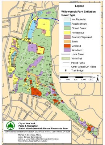
Following heavy rainfall, the brook reappears within this forest as a seasonal stream. In some parts of the forest, the brook forms freshwater wetlands, as seen in this 2011 Greenbelt Natural Resources Team survey, where Corson’s Brook appears as a wetland on the park’s western edge. Many highway shoulders in the city are also designated as parkland, dating from the time when Moses administered parks and highways at the same time. On this map, the route of the unbuilt parkway is visible as the tail end of Willowbrook Park.

3 thoughts on “Willowbrook Lake, Staten Island”