When I am not exploring the city’s hidden waterways, I like to give attention to the its lesser known waterfront parks. One such example is Barretto Point Park, which opened in 2006 in the Hunts Point neighborhood in the Bronx.

Surrounded by manufacturing facilities, it is a welcome patch of green on a bend in the East River.
Where it is
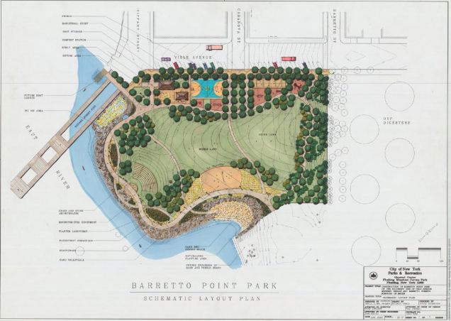
With my access to the Parks map collection, I found a schematic layout of the site that shows the park’s various elements, such as a playground, lawn, pier, beach, and outdoor amphitheater. It sits at the southern tip of Tiffany Street with Viele Avenue as its northern border.

Looking at the 1901 Sanborn atlas, the grid has been laid out but the landscape is almost entirely undeveloped. At the future site of Barretto Point Park is Leggett’s Creek, a short waterway that is entirely gone. Its only reminder on the map is Leggett Avenue further inland that connects the Hunts Point peninsula to the rest of the Bronx. This creek is so obscure that it did not make the cut for my book. A small cluster of homes on the property is Blthe Place, the estate of merchant, attorney, and State Assemblyman Francis J. Barretto (1794-1871), the park’s namesake.

A survey by the city’s Economic Development Corporation shows how much the peninsula’s shoreline has changed since 1921. Gone are Leggett’s Creek, along with Sacrahong Creek, Causeway Creek, and Old Creek. Bungay’s Creek is also gone, its only reminders are Intervale Avenue and its source, Indian Pond in Crotona Park. The indented shoreline has been straightened with bulkheads and riprap.
Prior to becoming a park, the site hosted a sand and gravel operation and an asphalt plant. Much of the land here is fill comprised of building materials. After the asphalt plant closed, it became an unofficial park for fishermen and local youths. After Parks acquired the site in 2001, it was transformed into a naturalistic landscape. fitting with its postmodern design, its shoreline is comprised of riprap rather than a seawall, and the park’s paths follow the site’s topography.
Tiffany Street Pier

On the park’s western edge is the Tiffany Street Pier, currently being reconstructed. The first pier at this location was built at the turn of the 20th century as a loading dock. In 1996, the city rebuilt the pier out of recycled plastic hardwood in a celebration of environmental sustainability. A lighting strike in August 1997 melted the pieces where the bolt hit the pier. It reopened in 2000 only to be devastated again by Hurricane Sandy in October 2011. When it reopens for the third time, there is much hope that it will withstand whatever nature throws at it.
Signs in the Park
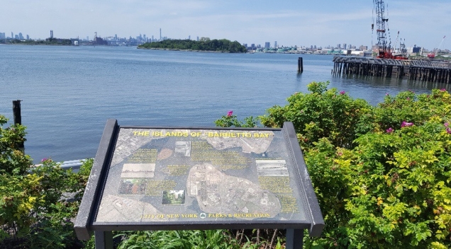
The bend in the East River between Astoria, Rikers Island and the south Bronx never had a formal name, but this informative sign in the park calls this section Barretto Bay, where it explains the history of Rikers, North Brother, and South Brother islands. Behind the signs one can see the Brothers, seemingly unspoiled on a waterway lined with docks, oil tanks and warehouses.
Looking East

The view to the east of Barretto Point offers Rikers Island, the 100-acre prison community. Behind it is LaGuardia Airport and Flushing Bay. As Hunts Point has a rounded shape, it is hard to tell where on the map the tip of this point lies.
Floating Pool Lady

In a city starved for land, its waterways have found use for floating public spaces, such as the Floating Pool Lady, a seven-lane pool fit for 170 people that has been moored off the park’s shore since 2008. The barge with a pool is the creation of Ann Buttenweiser, founder of the Neptune Foundation. Originally stationed at Brooklyn Bridge Park, at its current location it provides a place to swim and sunbathe in a neighborhood with a much greater need for such a facility. The pool is a revival idea, as a century ago the city had 15 such floating pools dotting its shorelines.
Water for this pool does not come from the East River, but is piped in from the city’s water supply and after use, piped out to the city’s sewers.
Playita
 In the years preceding the park’s creation, this section of the Hunts Point waterfront was known to locals as La Playita, Spanish translation for “the little beach.” In the redesign of the landscape, a small beach was carved out of the shore to give the park a sandy element for visitors seeking to touch the water (but no swimming please). Other recent waterfront parks, such as Mill Pond Park, Brooklyn Bridge Park, and Hunters Point South Park also have small beaches that are for sunbathing but not swimming.
Amphitheater

Since the time of the ancient Greeks who invented the amphitheater, a key feature of many stages is the background. On the Acropolis, the seats are carved into a hillside with the city of Athens visible behind the stage. At Barretto Point, audiences see Manhattan in the distance behind this stage.
Other Parks Nearby:
Through its South Bronx Greenway Plan, the city expanded green spaces in Hunts Point, along with another two smaller waterfront parks: Hunts Point Landing, and Hunts Point Riverside Park. I will write about their histories in the near future, as they deserve pages of their own.

5 thoughts on “Barretto Point Park, Bronx”