On its course through the borough that shares its name, the Bronx river passes through a variety of landscapes ranging from the dense forests of Bronx Park, to the postindustrial shoreline along its tidal section. Between these two elements is the neighborhood of West Farms, where the stream flows through a tight series of rapids between the Bronx Zoo and Starlight Park.
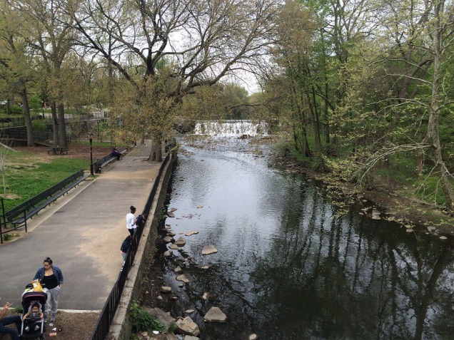
Here we have what appears to be a waterfall in the heart of the Bronx. The view is looking north from 180th Street.
Where it is
I love neighborhood maps that hang in subway stations. They offer so much detail and are easy to read. Even when they are undated, one can easily establish when they were printed based on what appears on the map.

On this map, the gap in parks along the Bronx River appears between 174th and 180th streets, the sections known as the West Farms Rapids. Today, the entire shoreline is Parks property, but not all of it is accessible. Bronx River Houses has been renamed after former resident Supreme Court Justice Sonia Sotomayor, a rare honor for a living person. Another anachronism is the dotted line in the Bronx Zoo indicating the Skyfari, which ran from 1972 to 2009.
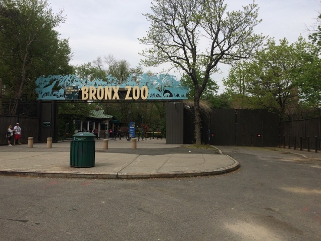
An aerial cable car, the Skyfari transported visitors above the African Plains, as its name suggests, it was a safari from the sky. On July 9, 2008, passengers were stuck above the hungry lions for five hours until rescue cranes plucked them down. As America is a very litigious society, lawsuits were filed and the zoo decided to cut its losses and dismantle the ride. At 265 acres, it’s the largest urban zoo in the country, and you can still ride on a bus loop or monorail inside the zoo. Enjoy them while you can.
Elevated Stub

Speaking of defunct transit lines, when exiting the West Farms Square station and heading north, one looks up and sees the active tracks turning east to cross the Bronx River and a set of ghost tracks protruding to the north. Prior to 1952, a spur extended north towards the zoo entrance. It was demolished in a decade when many New Yorkers purchased cars and moved to the ‘burbs. Instead of a dedicated station, parking lots at the zoo were expanded to reflect the trends. Another much-missed elevated line demolished in that decade was Manhattan’s Third Avenue El.
Gothic in the Bronx

At 2064 Boston Road is a Gothic revival institution built in 1901. The Bronx River flows behind it. In the first half of the last century, it was the Peabody Home for Aged and Indigent Women, and then the Circle Mission run by Father Divine, a charismatic African-American preacher based in Harlem. It is today the El Rio Residence, part of a complex for low-income and special-needs individuals.
By the River

A thin strip of land sandwiched between the water and the apartments is Bronx River Park, an unfinished park that has been in the works for nearly three decades. Once it is completed, it will serve as a link between Bronx Park and Starlight Park, effectively putting the nearly the entire course of the Bronx River within parkland.

Looking back at this location in 1930, we can understand why the West Farms Rapids were described as an “open sewer.” Stores and workshops along the shore spilled their sewage into the river. Where the park’s pedestrian path lies used to be Bronx Street, a long forgotten road. The photo above is from the NYPL Digital Collections.

Here’s another view of the rapids looking south from the 180th Street Bridge. On the left bank of the river is River garden, where cornstalks face the river. Tools are stored in a casita, a Puerto Rican-inspired “little house” that can be found in many community gardens throughout the Bronx.


The 180th Street Bridge is the a wide structure that carries multiple bus lines that loop around West Farms Square and drop off passengers visiting the zoo. Among the buses terminating here is the Q44, which runs from West Farms to Flushing and Jamaica, one of just two public bus lines connecting Queens and the Bronx. ON the concrete barrier by the sidewalk is a mini-mural commissioned by the city DOT’s Barrier Beautification program.
River Park

On a two-block stretch of the river north of 180th Street is River Park, a unit within the larger Bronx Park. Inside it is a playground, sitting areas and views of the 182nd Street Dam.

As a tribute to its name, the playground in River Park has a “stream” with bridges and animal sculptures. This is an ideal park for my toddler.
River Park Fish Passage

At the border of River Park and Bronx Zoo is the 182nd Street Dam. The barrier was first built in the 1600s to power a gristmill, one of three such dams on the river within the Bronx. This one was owned by the DeLancey family. During the American Revolution, local farmer Col. James DeLancey organized a loyalist regiment in this area. He fled to Nova Scotia after the war but his last name still appears on a street in Manhattan.
In December 2014, a fish ladder passage was built alongside the dam to enable the alewife to spawn upstream before returning back to the estuary at the river’s mouth.
To the Zoo
What if a sidewalk could tell the story of the Bronx River? For zoo visitors entering through the Asia Gate on Boston Road, the sidewalk between 180th Street and Bronx Park South offers etched bricks with poetry and illustrations relating to Native Americans and local wildlife on the river.
The Asia Gate blocks Boston Road’s entry into the park. An ancient roadway, it served as the main path between New York and Boston in colonial times. The section of the road within Bronx Zoo closed to traffic in 1939. North of the zoo, the road picks up the designation of U. S. route 1, a series of connected roads stretching from Fort Kent, Maine to Key West, Florida.
As the weather warms up, a visit to the zoo is on my mind. Inside, I will document the Bronx River, Lake Aggasiz, Cope Lake, and other hidden waterways within the zoo.
Events on the Bronx River

Much credit for information on the Bronx River in my book goes to the Bronx River Alliance, which is leading the restoration efforts on this waterway. This Saturday (rain date May 21) it will be holding its annual Bronx River Flotilla. Click on the banner above for details.
Books on Bronx River


Credit also goes out to the two books above. Stephen Paul DeVillo offers the real and fictionalized aspects of the river’s past, while Maarten De Kadt offers details on efforts to restore the river in the last three decades of the 20th century.

5 thoughts on “River Park, Bronx”