Along the glacial terminal moraine that stretches the length of Long Island are numerous kettle ponds that formed from chunks of ice that fell off the ice cap and melted in place. Some of these ponds are there today, such as Strack Pond and Potamogeton Pond, and other were buried such as Redder’s Pond and Jackson Pond.

Then there was Delta Lake, the triangular pond deep inside Cypress Hills Cemetery that was photographed by a city worker in 1927 ahead of its condemnation in favor of a parkway that would slice through the cemetery.
Where it Was

Looking at the 1924 city aerial survey and using an 1873 Brooklyn Daily Eagle guide to the cemetery, there were three ponds within Cypress Hills Cemetery: Delta Lake, Cypress Lake, and The Crescent. Highlighted above is the approximate path of the Jackie Robinson Parkway.
When the cemetery opened in 1848, the property was quite distant from the cities of New York and Brooklyn, straddling the border of Queens and Kings Counties, maximizing the allowable land for the cemetery by having it in both counties. Like its contemporaries, Green-Wood Cemetery and Woodlawn Cemetery, Cypress Hills was designed as a burial park, with winding paths that respected the topography, “hill and dale, plain and slope, forests and clearings,” circles with monuments, and natural ponds.
By the end of the 19th Century, the terminal moraine on the county line also included the Evergreens, Trinity, Bnai Jeshurun, Salem Fields, Machpelah, Union Field, Mount Neboh, Beth El, Mount Carmel, Mount Lebanon, Shearith Israel, and Hungarian cemeteries- a necropolis of many faiths and nationalities.
A Parkway for Brooklyn and Queens
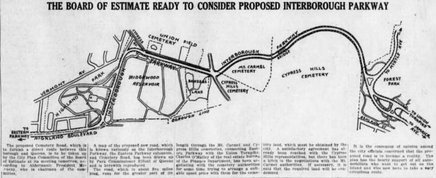
Following the annexation of Brooklyn and Queens to the City of New York, planners proposed extending Eastern Parkway further east towards Queens by running through Highland Park, past Ridgewood Reservoir and through the cemetery belt into Forest Park. As it was to straddle the county line, it was named Interborough Parkway. Above is a 1914 proposed route, from the Brooklyn Daily Eagle.
First proposed in 1899, it took until 1908 to secure state legislative approval. Construction began in 1927 but suffered delays as hundreds of graves at Cypress Hills Cemetery had to be relocated. To minimize disturbance to the dead, Delta Pond was sacrificed in favor of the parkway. This also explains for its tight curves, and lack of shoulders, laid out in a way that minimized the removal of graves.
Building a highway through or past a cemetery is a very practical policy, as the dead cannot protest a road running through their backyard.

The 1940 aerial survey of Interborough Parkway, from the city’s Municipal Archives shows the site of Delta Pond on the parkway in a natural depression between two of the cemetery’s bridges. The slope that overlooked the pond now overlooks the parkway, site of the Urn Garden, where cremated remains are buried. The two bridges in this photo were removed around 2000 during a highway reconstruction project.
Three years earlier, it was renamed for Jackie Robinson, the legendary Brooklyn Dodger who was the first African-American to play in Major League Baseball. In contrast to the RFK Bridge, Ed Koch Bridge, and Hugh Carey Tunnel, this recent highway renaming has been accepted by most New Yorkers. My guess: because Robinson was not a politician!
Other Cemetery Ponds

By the 1950s, Cypress Lake was gone and at this time, The Crescent has also been filled by the end of the 20th century, but new graves on it has not yet arrived. In the 1990s, the cemetery faced violations for using construction debris as landfill for future gravesites. Nearby, the cemetery belt also included Banzer’s Pond (which deserves its own blog post) and another next to Union Field Cemetery. The above 1909 Bromley map shows the Ridgewood Reservoir and some of the other cemetery ponds on this ridge.
Cemetery of the Evergreens
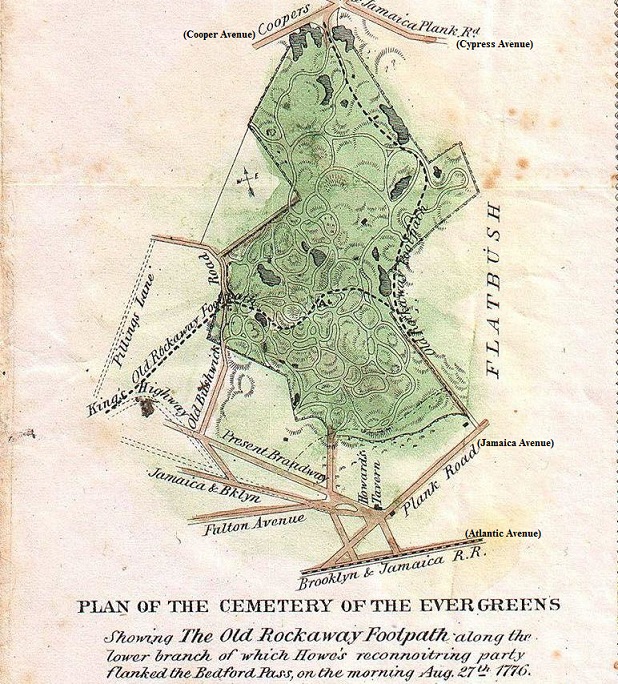
The 1867 Samuel Edward Stiles map of Brooklyn suggests that the Cemetery of the Evergreens also had a set of ponds, including a pond with a particularly tall tree that was used by the British as a lookout post during their 1776 invasion of Brooklyn.

All the ponds at this cemetery are gone, but it has a plot named Lakeside that preserves the memory of one such pond.

The most recent map of the cemetery containing waterways is from page 697 of the 1908 Brooklyn Daily Eagle Almanac, showing four ponds. It is unfortunate that as spaces for burying the dead and routes for highways have erased ponds that rested on the landscape for centuries before the arrival of people.
Explore the Cemeteries:
Here’s are the maps for Cypress Hills Cemetery and for Cemetery of the Evergreens.


Evergreeens has its own detailed book by John Rousmaniere, published in 2008; while Cypress Hills has a historical photo essay book by Arcadia Publishing released in 2010. Both of these books have been helpful in my research on the forgotten ponds of the Brooklyn-Queens cemetery belt.

4 thoughts on “Delta Lake, Queens”