The southernmost and perhaps least crowded public beach in New York City is at Wolfe’s Pond Park. It is a small stretch of sand on the otherwise pebble-strewn Raritan Bay. Behind the beach is a berm designed to hold back storm surges and behind it is Wolfe’s Pond, a historic waterway that nearly touches the ocean.

Down here, there are plenty of New Jersey radio stations playing on the radio, with Keyport and Keansburg facing across the bay. Like many parks on Staten Island, Wolfe’s Pond Park expanded in a piecemeal fashion, leaving a few homes within its borders. The homeowners live inside a forest knowing that they will never have to worry about other homes being built next to theirs.
Where it Flows

From the time that Staten Island was annexed by New York City in 1898, many of its maps were crisscrossed by paper streets laid out in anticipation of future development. Many of these streets would not become reality until after the completion of the Verrazano-Narrows Bridge in 1964, and some of these streets will never be completed. That’s what makes the above 1917 G. W. Bromley atlas from the NYPL collection more authoritative in telling the history of Wolfe’s Pond.
On this map, Wolfe’s Creek emerges a few yards to the north of the Staten Island Railway tracks, picking up a couple of tributaries before widening into Wolfe’s Pond. The excess water exits the pond through a creek that flows into Lemon Creek a few feet shy of its mouth at Prince’s Bay.
At the Source

The westbound service road of the Korean War Veterans Parkway (formerly Richmond Parkway) is known as Father Drumgoole Boulevard. An undeveloped and unnamed triangular block bound by the service road, Carlton Avenue, and Vernon Avenue in the Huguenot neighborhood was set aside in 1941 for a highway interchange that was never built. Instead it was designated as a park and regularly mowed by the city. In the middle of this parcel is a thicket of vegetation where one feels moisture and the ground is much lower. This is the swale where Wolfe’s Creek emerges to the surface.

Between the service road and the parkway the forestry is thick enough to stifle some of the noise and pollution from the highway. Wolfe’s Creek widens, but why is the shoulder space so wide here that it has such a lush forest?
Wolfe’s Pond Parkway

In 1941, New York’s highway coordinator and Parks Commissioner Robert Moses laid out a plan for Staten Island’s future, with highways and parkways stretching across the borough. From Outerbridge Crossing to Todt Hill, Richmond Parkway would run. Across the service road from the unnamed triangular park, a modified trumpet interchange would connect to Wolfe’s Pond Parkway, a one-mile spur connecting to the beach at Wolfe’s Pond Park.
The right-of-way was acquired by the city and appeared on Hagstrom maps as a dotted line through the 1970s, but not an inch of this spur was built, so the creek flowed undisturbed along what could have become a highway. This Hagstrom map is from the collection of Hank Eisenstein, shared with Steve Anderson of NYCRoads.com.
Woodhull Park

Between the westbound parkway and its service road there is also ample shoulder space with a thick forest and a constructed pond. Above, the creek leaves this pond and flows through a culvert, no trees are growing above it.

Across the service road is Woodhull Park, a forest reserved for the unbuilt Wolfe’s Pond Parkway that was released by the state to the Parks Department in 2005. Most of the park is kept undeveloped except for a playground at Woodhull Avenue and Drumgoole Road. The creek flows undisturbed through this eight-acre park.


Unfortunately, this preserve is not free of human debris such as abandoned shopping carts, plastic bottles, cans, and styrofoam cups. Wolfe’s Creek goes underground again at Amboy Road, passing beneath a couple of properties and the Staten Island Railway tracks.
Wolfe’s Pond Bluebelt
Reemerging on the south side of the tracks, the creek enters the forest section of Wolfe’s Pond Park, where it was restored and craved its present channel in 2004. At the corner of Chisholm Street and Eylandt Street there is a small plaza overlooking a constructed pond. Looking at older maps of this area, the creek and the pond are nowhere to be seen, devoured by the ugly street grid. Instead, undeveloped blocks were saved at the turn of the millennium, preserved forever as part of the Staten Island Bluebelt. It makes for confusing driving as Eylandt Street is comprised of four sections separated by nature preserves. within the preserve are unused fire hydrants and portions of sidewalks for streets that were never completed.

A plaque at this plaza illustrates the native aquatic plants of Wolfe’s Creek. Along with this unnamed pond, the creek also flows through Acme Pond, a natural waterway whose name brings up thoughts of Warner Brothers cartoons. It is a Greek term denoting the highest point. Entities striving for excellence call themselves acme with the “top of something” in mind.
Wolfe’s Pond Park

To the south of the island-spanning Hylan Boulevard, the park has recreational facilities for tennis, basketball, roller hockey, hiking trails, and a playground. It also has a memorial to veterans who fought in the Battle of the Bulge. The main feature of the park is its 16-acre pond, which is not accessible to boaters or swimmers.
Acquired in Parcels
As mentioned, the park was acquired in a piecemeal fashion. Prior to 1857, land around the pond belonged to its namesake farmer Joel Wolfe. That year the state acquired the land with a quarantine station mind. It would hold immigrants who were ill. As in Tompkinsville, local opposition stopped this project and the state had to create Hoffman and Swinburne Islands for the quarantine hospital.

In 1907, the land was sold to a developer and the Camp Huguenot bungalow community sprang up around Wolfe’s Pond. It was one of dozens of such communities on the island’s South Shore. The last one of these, Cedar Grove Beach Club held on until 2010. The photo above of Camp Huguenot comes from the Staten Island Museum collection.

The city made the first parcel acquisition for Wolfe’s Pond Park in 1929, seen on the above planning map as Parcel 1. The bungalow dwellers refused to leave and it took five years of litigation to compel them. In the meantime, parcels 2 through 5 were acquired, enveloping the pond in parkland. In the 1970s, following the cancellations of Wolfe’s Pond Parkway and Shore Front Drive, more parcels were added to the park, but by then a few of them had already been developed.

Above, a lone house on Cornelia Street is enveloped by parkland, giving the impression of a rural scene. At one time, the map here showed blocks of paper streets and empty private lots awaiting development.
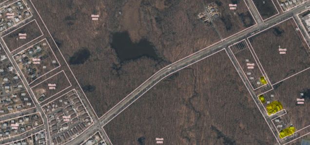
A detailed aerial survey from OasisNYC shows the holdout properties and the dead ends of unfinished streets deep inside Wolfe’s Park. Acme Pond is seen here, as is Hylan Boulevard cutting through the park. On the park’s western edge, we see undeveloped blocks and paper streets cutting through the woods, along with recently built tract houses that could have covered the entire map were it not for the parkland acquisitions.
Wolfe’s Pond Beach

The beach at Wolfe’s Pond Park is mostly comprised of small rocks, bricks from factories that closed long ago, and saltwater grass. A small section of sand is where the public is allowed to swim. The rocks date to the last ice age, when the glacial terminal moraine corresponded to today’s shoreline at Raritan Bay.

Resembling At-At Storm Trooper transports from Star Wars, these lifeguard shacks on stilts are a post-Sandy innovation designed to withstand storm surges. They can also be seen at the Rockaways and Coney Island.
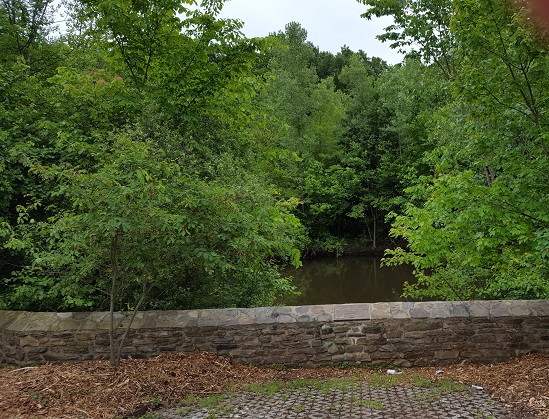
Berm

Wolfe’s Pond is believed to be a former inlet of Raritan Bay that became a freshwater pond as a result of beach sand carried by the current. The sand became a berm separating the waters. Periodically, large storms breached this berm and currents then btought it back. A taller berm was constructed in 1920 and destroyed in the infamous 1992 nor’easter. A sandbag wall covered with rocks and sand was constructed following that storm. In 2012, Hurricane Sandy breached the berm, filling the pond with saltwater and again the berm had to be reconstructed.

If I had to guess, the water in the pond could be perhaps a foot higher than sea level and when it overflows, an ephemeral creek flows through the berm towards the beach and the sea.
The Unbuilt Shore Parkway

The berm that separates Wolfe’s Pond from the ocean could have been much wider had the 1962 plan for Shore Front Parkway become reality. The proposed highway would have stretched from Conference House Park to the Verrazano-Narrows Bridge in a design similar to the Belt Parkway at Gravesend Bay and Cross Island Parkway at Little Neck Bay. That partially completed interchange at West Shore Expressway, Outerbridge Crossing and Korean War Veterans Parkway? It would have continued south to link with Shore Front Parkway.

As this 1962 map and letter show, the Master Builder saw coastlines as convenient right-of-ways for highways, not only on Staten Island, and with the Belt Parkway in Brooklyn and Queens, but also the unbuilt Shorefront Parkway in the Rockaways, and further east, Ocean Parkway on Jones Beach Island. Moses conveniently designated parkways and their green shoulders as parkland, leveraging funding for roads and parks into a single package. The only part of Shore Front Drive on Staten Island that was completed runs from Miller Field to Fort Wadsworth as Father Capodanno Boulevard, a street rather than a highway.
Highway on Seguine Point
In the 1962 highway proposal, the knob of land jutting into Raritan Bay, between Wolfe’s Pond and Lemon Creek, is clearly seen above. Seguine Point has a curious history as the site of the S. S. White Dental Manufacturing Company. The factory began operating in 1865. Between the 1890s and the 1920s, S. S. White was the largest employer on Staten Island, lovingly nicknamed “factory by the sea.” In the years following the Second World War, labor disputes at the factory inspired the management to relocate the factory to New Jersey in 1972.

In the rendering above, the highway would have followed the beach, condemning parkland and bungalow colonies, but preserving the factory. Certainly it would have relieved congestion on Hylan Boulevard, but is the environmental cost worth the benefit of a quicker commute?
And so it is thanks to a rare defeat for Robert Moses that Staten Islanders can see Wolfe’s Pond as it has appeared for centuries in its natural state, while keeping in mind that as sea levels rise and storms encroach, people must protect it not only from development, but natural forces as well.
Learn More:
Near Wolfe’s Pond is the mouth of Lemon Creek, site of the city’s last human-operated drawbridge. Its story is told on Forgotten-NY.

All of the exhaust from todays traffic (thanks directly to these scrapped highways) must do wonders on the environment. Oh well, killing more trees as I sit in bumper to bumper traffic on the SIE for 60 mins a day. Good one Environuts!
LikeLike
Fix the berm at wolf’s pond park, the fishing there used to be great.
LikeLike