At the northern tip of Manhattan island, the scenery is reminiscent of the Hudson River Valley at Fort Tryon and Inwood Hill parks. Thick forests, steep hills, and views of the Palisades across the Hudson River. The east side of Inwood on the Harlem River receives fewer visitors, but has a rich natural and human history of its own.

Sherman Creek and Swindler Cove offer a connection to the water’s edge, serving as examples of a waterfront restored to its natural appearance.
Where it is

Once a stream that originated further inland, Sherman Creek today is an indentation in the Harlem River at the northern terminus of the Harlem River Drive, where it continues in a northwest direction as Dyckman Street. To the cove’s south is Highbridge Park, which covers a forested ridge extending south to 155th Street. The cove is bound by Sherman Creek Park, Tenth Avenue, and Academy Street.
As it Was

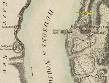
Looking at the 1832 David H. Burr map of Manhattan, the thumb on the tip of Manhattan is Marble Hill with Spuyten Duyvil Creek making its S-shaped course around it. Next to Fort George, the indentation that is Sherman Creek appears. At the time, the northern extent of the city’s street grid was 155th Street. As a reference, Burr extended Tenth Avenue to the island’s tip. At the time, only one road existed in the area, what is now Broadway. More on that later.
The Unbuilt Bridge
The above reference to Tenth Avenue as an uninterrupted road inspired engineer William Barclay Parsons to design a massive viaduct in 1887 that would extend Tenth Avenue from its terminus on Fort George Hill across Sherman Creek towards Inwood. The bridge was never built. In 1890, Tenth Avenue north of 59th Street was renamed Amsterdam Avenue, but the orphaned section of Tenth Avenue in Inwood, north of Sherman Creek kept its number, along with two pieces of Ninth Avenue.

Such daring attempts to extend the grid across valleys and coves are rare in uptown Manhattan, where one is more likely to find stepped streets that reconnect pieces of the grid. If one wishes to see a dramatic viaduct in Manhattan, visit the one carrying Riverside Drive across Manhattanville.
Source of Sherman Creek
 It is fed by two creeks, one corresponding to today’s Dyckman Street, and the other originating at 184th Street and Bennett Avenue in a valley nestled between Fort George Hill and Fort Tryon Park. Twitter account @Discovering_NYC posted a photo of Sherman Creek’s source a few weeks ago, an undated photo of Hessian Spring, where the creek emerged to the surface. The spring took its name after the German mercenaries who assisted the British in their successful 1776 conquest of the city. In colonial times, the creek was known to the Dutch as Half Kill and to the early English settlers as Round Meadow Creek. Its present name relates to a Sherman family that owned property along its banks in the early 19th century. Nothing more is known about them.
Revolutionary Battlefield

Looking at the historian’s report from the 1915 edition of Documents of the Assembly of the State of New York, Volume 21, the valley where Hessian Spring flowed was known as a “hollow.” There, Broadway descended on its way north from Washington Heights towards Inwood. During the American Revolution, highlands on either side of Broadway were topped by blockhouses designed to slow the northward British advance. On the west of Broadway, the present-day site of The Cloisters museum was Fort Washington. It faced Fort Lee across the Hudson River, aiming to fire at any British warship daring to sail north. Additional batteries were placed on Cox’s Hill in present-day Inwood Hill Park, atop Fort George Hill; and at Jeffrey’s Hook, a spit of land beneath present-day George Washington Bridge.
Sherman Creek’s role in the war was its location as an ideal landing site for the redcoats, who stormed Fort George, followed by Fort Washington on November 16, 1776. They conquered upper Manhattan within a day. Fort Washington was renamed Fort Tryon, in honor of New York’s last colonial governor. The British quit New York in 1783, but Tryon’s name remains in the park where the fort stood.
Heiresses on a Barge
 Every hidden waterway in the city has its human characters, eccentrics whose lives were intertwined with the stream of their choice. Sherman Creek’s most memorable resident were Isobel Stone and her sister Peggy, daughters of the wealthy Pennsylvania Governor Wiliam Alexis Stone who made his fortune in coal. As children, they were nicknamed the “pets of the White House,” running around its halls while their father met with presidents.
Their father died in 1920 and his $3 million fortune turned out to be a measly $3,000. In 1928, a reporter found the 23-year-old Isobel, and Peggy, 25, living on a derelict barge in Sherman Creek. The riches-to-rags story instantly became a national sensation. Peggy made sculptures, while Isobel wrote poetry and songs, aspiring to appear either on Broadway or in an opera. The news notoriety earned Isobel gigs at speakeasies, an engagement to a publisher and a ticket off the houseboat. Her half-brother claimed that her tale of poverty was a publicity stunt geared towards jump-starting her acting career. The fate of Peggy was not recorded in the newspapers of the time, but Cole Thompson’s encyclopedic My Inwood blog goes into detail on their brief stint as residents of Sherman Creek. The image of Isobel hanging clothes on her houseboat is from the Brooklyn Daily Eagle, August 4, 1928.
Dyckman Oval
At the intersection of Sherman Avenue and Broadway, the stream turned northeast and then east at Dyckman Street as it gradually widened into a salt marsh. In the late 19th century, Inwood was the last frontier of Manhattan, retaining a rural appearance long after most of the island was cut up by the street grid. Change arrived in 1906, when the Seventh Avenue Line was extended north of 145th Street. At the Dyckman Street station, the subway emerges from the ground and runs as an elevated line towards its terminus at Van Cortlandt Park. With the arrival of the subway in 1906, the streambed west of Nagle Avenue was filled and developed with apartment buildings.

To the east of Nagle Avenue, the marshland was partially filled by 1923, when the Dyckman Oval opened to the public. This early sports arena hosted boxing matches and was the home field for the New York Cubans, the local franchise of the Eastern Colored League. At the time, the major leagues were open only to white players and those of African and Latin American descent played in the colored leagues. The oval closed in 1938 and the Dyckman Houses were completed on its site in 1951.

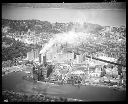
With the construction of Dyckman Houses, Sherman Creek was reduced to an inlet of the Harlem River. Tenth Avenue was constructed atop the landfill, connecting Inwood with Harlem River Drive. In the 1951 photo above, from the New York State Archives, the seven public housing towers stand atop the filled creek. In the foreground is the elevated subway line, and at the confluence of Sherman Creek and Harlem River is the Sherman Creek Generating Station. More on it later.
Boating on Sherman Creek
 The cove that was the remnant of Sherman Creek has a rich history as a haven for competitive boating. Above is a Percy Loomis Sperr photo from 1935 showing the beautiful boathouses on Sherman Creek.
From the late 19th century through the 1950s, the section of Harlem River between Sherman Creek and 145th Street Bridge rivaled Philadelphia’s Boathouse Row and had its own nickname, Scullers’ Row. Spectators gathered along the Harlem River Speedway, Fort George Hill, Washington Bridge, and High Bridge to watch rowing processions. On May 11, 1902, a day-long rowing club procession comprised of 150 boats powered by over 600 oarsmen representing 11 rowing and boat clubs.

Over the following decades, rowing declined on the Harlem River as pollution, highways and parkland encroached on its once-tranquil shores. A New York Times article on Scullers Row from October 1941 listed only three rowing clubs remaining at Sherman Creek Inlet, all on land owned by the city’s Dock Department. The city sought to evict the boaters in order to use this section of the shoreline as an ash dump. Ironically, Dock Commissioner John McKenzie was an avid rower in his youth, practicing the sport at Flushing Bay in Queens. Local Universities also had boathouses on the Harlem River.
The last holdout was Fordham University, whose boathouse was destroyed by an arsonist in 1978. A mile to the north where Spuyten Duyvil Creek cuts through Marble Hill, Columbia University has its Gould-Remner Boathouse, which dates to 1929 and is still in use. For the following two decades, Sherman Creek fell into decay as an illegal dumping site.
Power Plant on Sherman Creek
In the early years of electric power, generating plants were often built close to the shore in order to facilitate the delivery of coal from barges. The Sherman Creek Generating Station opened on October 24, 1913. At an official opening a few months later, a crowd of thousands took the subway uptown to marvel at this cathedral-sized wonder of technology.

Among those who gazed at this facility were Harlem Renaissance artist Aaron Douglas (above) in 1934, and the Polish-born landscape painter Wladyslaw Brzosko in 1962. My Inwood blog offers examples of other artists who visited Inwood to paint its scenes.
By 1970, the turn-of-the-century Sherman Creek Generating Station was obsolete and ceased generating power. For the next three decades, it stood as a vacant beaux arts structure. The first major attempt at redevelopment was in 1972 by 34-year-old architect Richard Dattner under the title Sherman Creek State Park, which envisioned a hollowed out power plant filled with indoor sports activities such as basketball, ice skating, and bowling; along with 42,000 residential units. The recession of 1975 killed the Dattner plan and the power plant stood unused until its demolition in 1997. Dattner is also the designer behind Riverbank State Park in Hamilton Heights, the only state park in Manhattan.
Substation with Sails

The successor to the plant is the much smaller Con Edison Academy Substation, which opened in 2011. Seeking a design that blended into with the neighborhood and acknowledged its history, the walls of the structure facing Sherman Creek feature sail-like sculptures and above the main entrance on Academy Street is a rotunda resembling a lighthouse.

It isn’t the only fake lighthouse in the city. There’s a cell phone tower on Todt Hill disguised as a lighthouse; at a seafood restaurant in Sheepshead Bay; and a decorative one atop an office building in the Bronx. If anyone knows of other non-navigational light towers in the city, let me know. The subdued appearance of Sherman Creek’s electric substation is part of a trend, studied by Manhattan Institute, that includes one in Mott Haven that has a rowhouse look, and another concealed inside the World Trade Center.
Restoration of Sherman Creek, Formation of Swindler Cove

Credit for the restoration of Sherman Creek rests largely on the New York Restoration Project (NYRP), which arrived at the site in 1996, launching a massive three-year cleanup effort followed by the reintroduction of native plant species along its shores. Where an aspiring prima donna lived on a houseboat, a bona fide Broadway diva, NYRP founder Bette Midler, rolled up her sleeves and participated in Sherman Creek’s restoration.

On the southern side of Sherman Creek, is a U-shaped indentation in the shoreline with a footbridge crossing it, Swindler Cove, which has a 5-acre preserve around it. Swindler Cove Park opened in 2003 and features a freshwater pond, cove and a floating boathouse. Its namesake was community gardening advocate Billy Swindler, who introduced NYRP Founder Bette Midler to the site. Swindler died of AIDS in 1997 at age 39.

Funding for this park came from the state, which contributed $10 million, and Midler, who raised another $2.3 million for its floating boathouse. In recognition of the shoreline’s history as Scullers Row, the Peter Jay Sharp Boathouse was designed in the late Victorian style by architect Robert Stern and Armand LeGardeur, who looked to old photographs of local boathouses for inspiration. Its namesake was a New York hotel and real estate owner who was involved in a variety of civic causes. Among its users are the crew teams of Fordham University and Manhattan College. Annual races at this boathouse include the Harlem River Classic, Heroes Row the Harlem, and the Peter Jay Sharp Regatta.
The boathouse brought back some of the rowing culture to Sherman Creek and Harlem River, while Swindler Cove recreates the natural conditions of the site where the British landed in 1776 in their fight for upper Manhattan.
In the News:
New York Times reports on the real estate boom along the East River shoreline in Astoria.

I love your blog. it’s right up my alley!
LikeLike
More wonderful history. I’m forwarding the link to a bunch of people who I hope will find it as fascinating as I do.
LikeLike
Hi I am a photog / reporter for the Staten Island Advance. I found your post cards of the Martlings Damn to be amazing and would like to use them in a short article to go with my Then & Now Clove Road piece.
Did you get rights for their use or are they public domain?
Thanks for your help
Jan Somma-Hammel
jsomma@siadvance.com
LikeLike
Most of my photos are from the NYPL Digital Collections: http://on.nypl.org/2lzlmaK
LikeLike
I wonder if you can help me research this following information ” On September 19, 1701, Jan Bastiaensen bought from Peter Van Oblienas a tract of land on Sherman Creek (Harlem) which became the well known Kortright farm, which continued in the family till 1786. Here, Jan, built and lived till very aged, at least his name remained in the tax lists until 1753.” Your article states a different person purchased land on Sherman Creek. Perhaps there were several. Can you tell me how/where you obtained your info? I am just doing family history research. Thanks, Julie
LikeLike
While attending grade school at PS 152 in Inwood a teacher told us that Broadway was originally an Indian trail. If this is so perhaps you can lead me to information explaining how these earliest travelers might have crossed from the island into what is now the Bronx. (Marble Hill? Dyckman Creek? Low tide up there somewhere when the Hudson an Harlem ebbed?
Cordially
Bob Schermer
LikeLike