The waterway that started my fascination with hidden urban streams is the 2.5-mile Mārupīte on the eastern side of Riga, my birthplace city. This was the stream that I’ve known since birth.

The scene above is with my mother at Arcadian Park (Arkādijas Parks) where the Mārupīte flows through an Olmstedian landscape a couple of blocks from my grandparents’ home.
Where it Flows

On the tourism map above, the Marupite emerges as a trickle from the peat swamps and farm fields between the villages of Tiraine and Marupe to the southwest of Riga, crossing the city line into the Bieriņi neighborhood. The creek widens into the Māras Dīķis pond, flows through Arcadian and Victory parks, emptying into the Daugava at Agenskalna Bay.
At the Source
 In contrast to some of the urban creeks that I’ve documented, where there is water seeping out of the ground at an identifiable location, the Mārupite has multiple sources including a large swamp to the south of the village of Mārupe. At the village’s edge, a couple of drainage ditches merge to form the creek. Continuing north, the creek is paralleled by Mārupite Gatve (Avenue) for the next 1.4 miles.
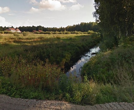
The creek appears very modest within Marupe, at times expanding its banks following a heavy rainfall. The village was developed in the 1920s and transformed into a collective farm during the Soviet regime. Today it is an attractive suburb of Riga, only a half hour drive from the capital city’s center.
At the City Line

The creek enters the city of Riga near Brūklenu Iela (Street) which I initially thought was related to Brooklyn but I don’t speak Latvian. Brūklene is Latvian for lingonberry, a popular local fruit that is often picked in the forests on weekends by city residents, crushed into a jam and spread on bread or biscuits. American consumers are familiar with the lingonberry by way of the Swedes as it is sold at IKEA locations. The neighborhood is Bierini, nearly indistinguishable from Marupe with its suburban homes and large backyards.

In contrast to Marupe, within Bieriņi the creek flows through a thickly forested ravine that is followed by a trail. Above, Brūklenu Iela crosses over the stream in a thicket of pine trees. One of the most enduring childhood memories that I have is the pleasant aroma of pine that is Latvia. The country does not have gold and silver lodes. Its amber jewelry comes from the hardened sap seeping out of these trees.
Beneath the Highway

The sylvan idyll of Bieriņi is interrupted at Ives Iela by a highway overpass carrying Kārļa Ulmaņa Gatve. Named after Latvia’s last pre-Soviet president, this limited access highway connects Riga and the seaside city of Jurmala. The road was mapped in 1965 and completed in 1891, initially named after German communist Ernst Thalmann.
A victim of history, Thalmann lost the 1932 election to Hitler and was quickly imprisoned by the Nazis. In the 1939 agreement between Hitler and Stalin, Latvia fell into the Soviet sphere of influence. Although the Nazis and Soviets briefly made nice to each other in carving up eastern Europe, Stalin did not bring up Thalmann in the treaty, leaving him behind in Nazi captivity, where he later died.
Kārlis Ulmanis was also a victim of history. Following the Soviet annexation of Latvia in 1940, he was imprisoned and later deported to Turkmenistan where he died. His brother’s grandson Guntis Ulmanis served as Latvia’s second post-Soviet president in the 1990s, a fitting tribute to an elder Ulmanis whose administration was abruptly deposed. A rare highway with ramps and cloverleaf interchanges, it was often used by Soviet filmmakers as a stand-in for American highways.

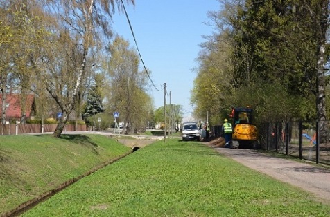
After the highway, the creek dips beneath the Riga-Tukums railway trestle, goes underground at Marupes Street (above) and emerges to the surface when it widens into the Maras Dikis Pond.
Māras Dīķis Pond
As a child, I often strolled with my grandparents around this pond. My mother has a history here too, having nearly drowned after falling into the ice here in her youth. The pond is located in the Torņakalns neighborhood, a block away from my grandparents’ home.

The pond has a history going back to the Middle Ages, when the German Order of the Brothers of the Sword led a crusade into the Baltic regions, seeking to conquer and convert the indigenous peoples. In 1209, eight years after the founding of Riga, a mill was constructed on the Marupite, forming this pond. In the late 15th century, the church-owned mill was transferred to the Riga municipal authorities.
Between 1621 and 1626, Poland-Lithuania and Sweden fought a war over Livonia with the front line stalled at Maras dikis pond. Although Poland won the war, seizing a sizable chunk of present-day Latvia, Riga remained under Swedish control. The battle at the old mill inspired the historical novel “Three Devil’s Servants” by Rutku Tevs.

The mill defended Riga again in 1651 when Russian forces tried to capture the city. To slow their advance, the Swedes opened the mill’s sluices, flooding the plains on the Daugava’s left bank. In 1703, they were not as fortunate. The Russians burned the mill and soon captured the entire eastern Baltic coast for their expanding empire. Following the Russian victory in the Great Northern War, the mill was rebuilt and worked for another two centuries.
A map from 1791 and another from 1905 from the site neogeo.lv show the location of Maras dikis pond and the growth of the city around it. The first map is in German, the language of the Baltic German nobles, while the second is in Russian. As the First World War approached, the Russian government insisted on using the tsar’s language in official documents, rather than that of a potential enemy.
The Mill Site

The mill was demolished in 1924 when the #10 streetcar line was constructed on the mill site, where the creek leaves the pond. The site is at the intersection of Ojāra Vācieša Street and Friča Brīvzemnieka Street, crossing the creek. The pond once had recreational boating, ice skating, and until 1959- swimming. Below is a 1920s postcard from the Latvia National Library collection, showing a rowboat in the pond.

Childhood Landscape
On the eastern side of the pond is the Torņakalns neighborhood. Its name translates to Tower Hill, named after a red brick medieval defense tower that defined its skyline in the Middle Ages. It is an upscale suburban neighborhood that is the first stop on the commuter railway after the Riga Central Station. By appearance, the closest comparable New York neighborhood to it would be Kew Gardens.
This is where I was born, raised for my first four years at 28 Torņakalna Street in a home shared by my grandparents, their in-laws and children, and my parents. It was a multi-generational household with a sizable backyard where we grew our meals and ate them outdoors in the summertime. Across the street was an old manor that was confiscated by the Soviets and used as a kindergarten.
When Latvia regained its independence, the old “baron’s” family returned to claim the property. A couple of blocks to the east was the railway from which we took the train to the beaches of Jurmala or my uncle’s summer cottage in Zvejniekciems. Following independence, an old freight car was installed at this station as a memorial to the tens of thousands of local Latvians who were deported from here to Siberia in 1940 and 1949. Most of them did not survive to return.
It was easy to tell the time as the local Lutheran church bell rang every hour a couple of minutes from my home. The textile factory where my grandfather had his last job was also a close walk, just beyond the church. Everything was within walking distance: the bathhouse, Agenskalns Market, children’s hospital, and three sizable parks along the Marupite. These are my visual memories of Torņakalns.
Around the Pond

An early suburb of Old Riga, the neighborhood is filled with old manor homes. Along Ojāra Vācieša Street are a few that overlook the pond, including Altona (above). Built in the 1770s, it functioned as an inn where visitors stayed and ate, enjoying views of the scenic pond. Latvian writer Ojārs Vācietis lived in this home, which is now a museum dedicated to his life’s work. Following his death, the section of Altonavas Street running past this house was renamed for Vācietis. The type of beret worn by him was also a favorite of my grandfather. Could be the popular clothing style of Torņakalns residents.
The neighborhood has a strong literary identity. Across the street from the Vācietis house is another old manor that was home to poet Jānis Akuraters. A veteran of the country’s struggle for independence, he served as the first director of Latvia’s national radio. This house is also today a museum. Another block to the north, Ojāra Vācieša Street intersects with a street named for Fricis Brīvzemnieks on the site of the Maras Dikis mill. Keeping with the neighborhood theme, Brīvzemnieks was also a poet, as well as a linguist and publisher of Latvian folklore.
Arcadian Park to the Daugava
A page as detailed on a hidden urban stream needs plenty of space. In Part Two, I document the section of Marupite flowing between Maras Dikis Pond and the Daugava River. This includes Arcadian Park, Victory Park, the site of the Red Tower, Latvia National Library, and Agenskalns Bay.
Learn More:
Can’t get enough of my coverage of international urban streams? Check out the site Hidden Hydrology for more examples in cities worldwide.
In the News:
Wall Street Journal reports on the city’s $160 million acquisition of the CitiStorage warehouse, completing the footprint for Bushwick Inlet Park in Brooklyn.
Bronx Times reports on the proposal for a new waterfront park in the Throgs Neck neighborhood of the Bronx.
Untapped Cities reports on 10 NYC neighborhoods with thematic street names.
Untapped Cities covers the history and nature of Inwood Hill Park in Manhattan.
Chicago Magazine reports on the benefits of restoring urban rivers, including the Chicago River.
AllAfrica.com reports on efforts to clean up the rivers flowing through Addis Ababa, Ethiopia.

One thought on “Mārupīte, Riga: Part One”