In the northern Midwest near the headwaters of the great Mississippi River are the “Twin Cities” of Minneapolis and Saint Paul. The former is the largest city in Minnesota while the latter is the capital city. On account of its post-glacial landscape, the state is nicknamed Land of 10,000 Lakes, and Minneapolis’s name is a portmanteau of the Sioux word for water and the Greek word for city.

One such example is Bassett Creek, which flows for 12 miles from its source at Medicine Lake to its confluence with the Mississippi near downtown Minneapolis. The photo above shows the creek emerging from its sewer in a cove just a few yards shy of the Mississippi River. In the suburbs, the creek runs through a few parks, but its final 1.7 miles are in a tunnel, constructed in the early 20th century beneath an expanding city.
Where it Flows
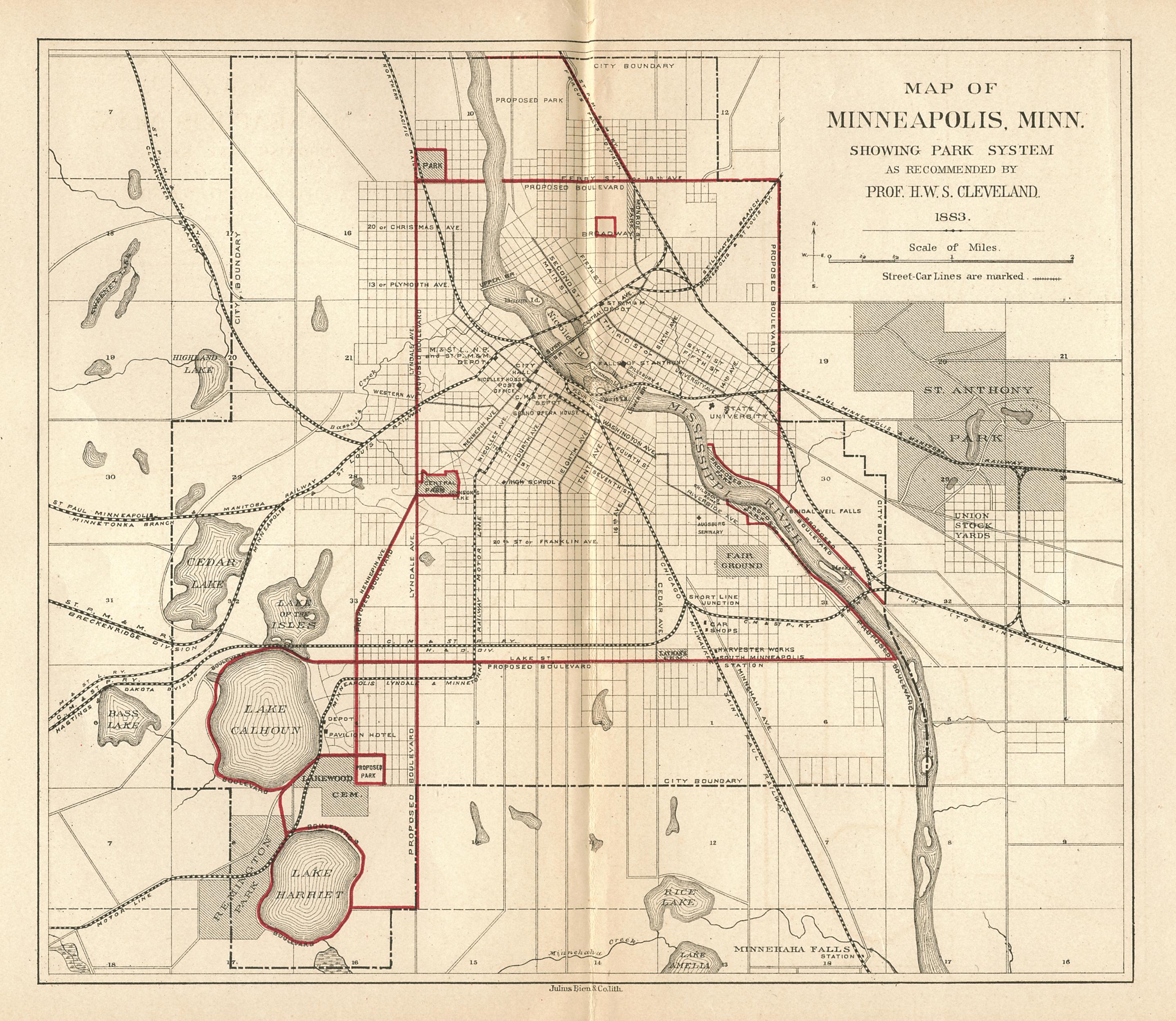
Looking at the 1883 Horace Cleveland map of the city, Bassett Creek appears to flow in a northeast direction towards the Mississippi, emptying into its just south of the Upper Bridge, facing Boom Island in what is now the Warehouse District. The creek got its name from Joel Bean Bassett, who built his first farm at the creek’s mouth in 1852. Within a generation of his arrival, mills and rail yards turned the creek into an “mammoth sewer” and in 1876 the City Council deliberated straightening the creek and transforming it into a sewer. Even Horace Cleveland, the city’s parks planner in the 1880s, did not see a bright future for Bassett Creek, leaving it out of his 1883 plan, Suggestions for a System of Parks and Parkways for the City of Minneapolis.
Heritage Park


One example of the channelization, burial, and restoration of Bassett Creek is in the Sumner-Glenwood neighborhood. Above, the 1892 map of the area and a Google maps aerial survey. For reference, I highlighted the diagonal Glenwood Avenue and Olson Highway. As with New York’s Five Points, the neighborhood built atop the buried creek quickly became a slum. In a time of racial segregation, Sumner-Glenwood was the city’s African-American district. In the 1950s, unattractive public housing projects were built in this neighborhood, perpetuating segregation in a de facto manner.
The 1992 lawsuit, Hollman v. Cisneros, led to a settlement where the decrepit projects were torn down in favor of a mixed-income community that included renters and homeowners, senior homes and working families. The rigid grid was distorted into the neo-urbanist Heritage Park that located Bassett Creek and daylighted portions of it inside the neighborhood’s parks.

The new central road through Heritage Park, Van White Memorial Boulevard, honors the city’s first black mayor and takes a meandering path with a bioswale median evoking the creek. The boulevard largely takes the path of DuPont Avenue, which ran above the Bassett Creek sewer.
North Loop Redevelopment
Downstream from Heritage Park, across Interstate 94, the Bassett Creek sewer travels beneath the Warehouse District, a formerly industrial neighborhood slated for redevelopment in the city’s 2003 Downtown East/North Loop Master Plan, and its 2010 follow-up, North Loop Small Area Plan.
Curiously, the user-generated content on Google Maps includes the route of Bassett Creek beneath its streets, roughly paralleling N. 8th Avenue between Heritage Park and Mississippi River. A 2006 survey commissioned by Hennepin County recognized the possibility of daylighting the creek. “This canal could also provide a storm water detention function and assist in improving water quality prior to this water being drained into the Mississippi River,” wrote the report’s author Dan Cornejo.
In 2010, the North Loop Neighborhood Association commissioned a Park Scoping Study to outline the benefits of a linear park with a creek along N. 8th Street. It provided examples in Mears Park, St. Paul; and Tanner Springs Park in Portland, Oregon, as examples of parks with restored waterways.

Parking lots that sit atop the sewer can easily be transformed into waterways within a linear park. In the Master Plan, maps of the rezoned district allow for this possibility, but a final decision has not been made. In December 2015, city deputy park superintendent Jennifer Ringgold noted that daylighting is not feasible as the creek sewer is too deep beneath the surface.

Beneath the surface, the arch bridges that crossed the creek are still there and could reappear in a manner resembling Madrid or Manchester.
Bassett Creek Commons

From Van White Memorial Boulevard’s crossing of Bassett Creek, one sees vegetation concealing the creek, power lines, and vast parking lots used for impounded vehicles and school buses. Nearly 500 feet west of this bridge, Bassett Creek enters its sewer, emerging sporadically within the green spaces of Heritage Park. If plans by the city become reality, this valley could become a new park, along with a new commercial-residential strip alongside the former parking lot that used to be 32-acre Linden Yards. and a light rail station alongside the freight tracks that run through this site.
The new park would be connected by bike trails to other parks upstream along the creek stretching as far west as Medicine Lake, where the Luce Line State Trail would take bikers and joggers another 63 miles west to Thompson Lake near the farming town of Cosmos. Thus, the expansion of parkland along a restored Bassett Creek would transform this stream into an important gateway to the west. This time instead of canoes, travelers would go on bike or foot, exploring the history of a city and the larger state that lies to its west.
Within Minneapolis, Bassett Creek has been the unsung counterpart to Minnehaha Creek on the city’s southern side. The latter has a famous waterfall, figures prominently in literature, and has a linear shoreline park dating to the time of Horace Cleveland, soon Bassett Creek will be earning its green stripes as well.
In the News:
Southwest Journal of Minneapolis reports that a design team has been selected for the Water Works riverfront park.
Star-Tribune of Minneapolis reports that a dam destroyed by a 2014 flood in Blue Mounds State Park will not be rebuilt, allowing Blue Mounds Creek to flow freely.
NY1 News reports on the shoreline restoration project at Meadow Lake in Queens.
Huffington Post contributor Charles A. Birnbaum writes about some of the innovative urban parks around the country, including my city’s Parks Without Borders initiative.

I believe by “flow in a northwest direction” you might mean “flow in a NORTHEAST direction”
LikeLike
Great article. One note: Van White was not the city’s first African-American mayor, he was the city’s first African-American member of the city council.
LikeLike
The tunnel shown hasn’t carried Bassett’s creek in decades. It was re-routed to a deeper tunnel that does not follow the historical creek bed at all. Bassett’s Creek outflows into the Mississippi below water level in Mill Ruins Park under St, Anthony Falls and is not visible there. Also, the Van White Boulevard “daylighted” portions of the creek are in fact stagnant pools of street runoff, not connected to the creek, which are actually above the original tunnel which follows the original route of the creek. The Van White BLVD project was misrepresented to the public by the City of Minneapolis as daylighting, when in fact, it was just the opposite. Also interesting to note: The original creek bed and tunnel are quite shallow relative to street level. (the original creekbed is visible through rain sewer grates for its entire covered run) It is only the 90 foot deep replacement tunnel, built simultaneously and in conjunction with the Van White project that is undaylightable.
LikeLike
So much I didn’t know. Thanks!
LikeLike
Matt, what is the inlet just south of the Plymouth Avenue Bridge across the Mississippi. Isn’t this the Bassett Creek outfall? It used to be. Click on one of the picture icons. It says Bassett Creek Outlet.
LikeLike
That is the original historical outlet. The inlet to that is still located 3/4 of a block east of Fremont on Second ave North. Its still visible from the sidewalk on Second Ave. North. but it no longer carries the creek. A parallel channel was dug about fifty yards south of the original second ave inlet which enters the new inlet south of the old one. From there, the creek now falls down a 30 foot drop structure which prevents river fish from swimming their old upstream route, runs under downtown, connecting with the downtown storm sewers, and outfalls through a double box culvert in mill ruins par below normal river water level. There is a historic route, and there is the current route which was institutued in conjuction with the Van White BLVD development project. .
LikeLike
i was so curious about why there is no flow out of the historic outfall that I called the lead project engineer for the re-routing of the creek about 15-20 years ago, and he was kind enough to direct me to exactly which manhole to stand on at rivers edge in mill ruins park to be at the new outfall during normal river water level. Its located directly beneath the center of the lower raceway area in Mill Ruins Park now.
LikeLike
The original tunnel that follows the original creek bed you remember still exists from the historical river outlet shown in the picture, and continues upstream to its dry inlet on second avenue north, 3/4 of a block east of Fremont. But it is now only used to convey local street run-off from second ave downstream and is no longer a connected part of the flow.
LikeLike
Where is the bridge at
I love in goldenvalley so I can get a good idea of how it started and to study for it.
LikeLike
I have a vague recollection of a building that had a window in the basement floor where you could see Bassett Creek flowing. I cannot find any reference to where that might have been.
LikeLike