The city of Detroit derives its name from the French word for the strait that connects Lake St. Clair with Lake Erie. At 24 miles, it is among the shortest of the country’s urban rivers, but it carries water between the Great Lakes and forms the U. S. – Canada border lending to its significance. Once a French colonial trading post, Detroit expanded as a city, along the way covering up some of the smaller streams that drained into the Detroit River.

The above photo was taken by the advocacy group Conner Creek Greenway, which seeks to create a continuous bike and pedestrian path that approximates the course of this hidden Detroit waterway.
Course of Conner

The map above was designed in 2015 by Lars Gräbner for the book Mapping Detroit: Land, Community, and Shaping a City. On what is now a grid-covered prairie we see numerous streams flowing into the Detroit River, many having French names bestowed by fur traders before they were pushed out by the English. Conner’s Creek was given its present name around 1840 in honor of local landowner Henry Conner. Prior to that, it was Twombley’s Creek, and its first European name was the fanciful Riviere du Grand Marais” (River of the Great Marsh).
The native trails that followed the creek were upgraded to roadways and then railways, and in one section, an airport runway, in the process reducing the marshland and eventually displacing the creek. The stream had its headwaters at a point near Eight Mile Road, the northern limit of the city. Where Conner Street lies was once the stream bed of this creek.
What’s there today?

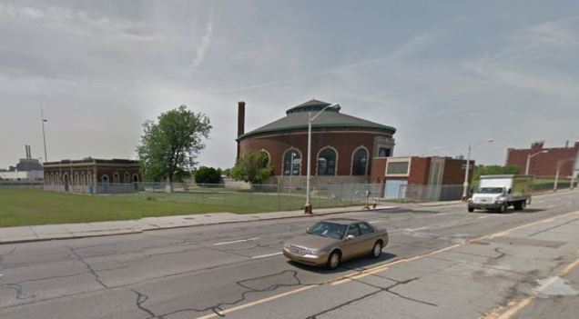
Conner Street branches off from Eight Mile Road at Bramford Street in the Bel Air neighborhood in the northeastern corner of the city. After a half-mile grid-defying jog, Conner Street merges with Outer Drive East, which follows the buried stream’s course southward. At Seven Mile Road and for the following mile south, Mount Olivet Cemetery sits atop the former course. The historic Catholic cemetery had its first burial in 1888 and retains a countryside appearance but with one major change.

When the cemetery opened, Conner Creek ran through its grounds and has since been buried. Another open area where the creek has been buried is Coleman A. Young Airport, seen below with the cemetery on the right and a closed section of East McNichols Road separating them.

As it was with airports in New York (think LaGuardia, JFK, Floyd Bennett Field, Flushing Airport), this one was also built atop a body of water because it undeveloped and nearly flat. The airport site was selected in 1922, with the first airplane landing here in 1927. Initially known as Detroit City Airport, the municipally-run field lost most of its air traffic to Wayne County Airport and its runways haven’t seen a passenger jet since 2000.
On the airport’s western side are empty residential lots along French Road, their owners bought out in phases by the city in order to meet a federally-mandated buffer zone around the airport. The footprint expansion accompanies hopes for the airport’s revival. South of the airport is Gethsemane Cemetery, which is much smaller than Mount Olivet. From this point, Conner Street travels past a series of former industrial sites that have been partially reclaimed as green spaces.
Conner Playfield is one example, occupying the Hudson Motor Company stamping plant. The facility was used by General Motors until 1986 and subsequently abandoned. The factory building is still standing with the nearly mowed grass of Conner Playfield facing Conner Street, while the rest of the property is an untamed prairie littered with the detritus of an earlier time.

South of the I-94
Conner Street crosses Interstate 94 passing by the the eastern campus of Wayne County Community College and the former Mercy Hospital, now the Samaritan Manor nursing/rehab center. Both facilities have ample green space on their properties that could be transformed into a daylighted stream.

Crossing East Warren Avenue, the buried stream bed once flowed between Conner Street and St. Jean Street, what was a vast freshwater wetland developed into car manufacturing sites such as the Chrysler Mack engine plant and Chrysler’s Jefferson North Assembly Plant.
Looking for hints of the buried creek on the largely empty landscape, there is the Conner Creek Pumping Station on Jefferson Avenue, a unique circular structure. The prairie around is was once the Berry Brothers varnish company, one of the first industries built along the creek. It was linked to the outside world by the Detroit Terminal Railroad, a freight rial spur that followed the creek south of Gethsemane Cemetery to its mouth at the Detroit River. This rail line later served the Chrysler and Hudson car factories. Built in 1905, the rail line encircled the city, picking up and dropping off materials at numerous factories along its route in a manner resembling New York’s High Line.
To the south of Jefferson Avenue, Conner Street becomes Clairpointe Avenue. The stream emerges to the surface a half mile south of the pumping station as an inlet of Detroit River lined with parkland on its banks. The inlet was carved in 2005 as part of the Conner Creek CSO Control Facility project that built the largest sewer treatment plant in Michigan.
At the head of the inlet, the project provided for a park with a boat launch, fish pond and Maheras-Gentry Park at the creek’s mouth on the Detroit River.
Conner Creek Greenway
The dramatic decline of industry, racial tension and suburban flight greatly reduced the population of Detroit in the last quarter of the 20th century, leaving plenty of unused properties that were either abandoned or demolished in favor of vast tracts of empty space. and possibilities for urban renewal not tried anywhere else in the country. Seeking to reconnect the city’s neighborhoods, proposals for greenways have appeared on the city’s map, using abandoned rail lines, former stream beds, and major roadways as linear parks.

The Conner Creek Greenway is one such example, a route to be taken by bikers, joggers residents and visitors interested in the city’s automotive heritage. Launched in 2003 by the Detroit Eastside Community Collaborative, a coalition of civic groups, it presently stretches for 4.5 miles along the former stream bed.

The greenway initiative is reminiscent of the 1915 proposal by the Detroit City Plan Commission to line Conner Creek with parkland. Instead the creek was almost entirely buried in the 1920s to make way for car manufacturers.

At the time Belle Isle functioned as Detroit’s counterpart to New York’s Central Park- Olmstedian, rugged and large. But city planner Edward Herbert Bennett regarded the park as flawed as it concentrated all of Detroit’s recreational features in one place instead of spreading them across the city’s neighborhoods.

What’s old is new again and a plan laid out 101 years ago serves as an example for the Detroit of the 21st century. It was very much on the minds of urban planners last week, who met in Detroit for the 24th annual Congress for the New Urbanism, a week of conferences and presentations that included my employer, NYC Parks Commissioner Mitchell J. Silver.
The Motor City provides a pioneering feel for long-timers and newcomers, where urban gardens, re-purposed factories and skyscrapers, and a deep sense of place are fueling the once-great city’s revival. The restoration of open spaces along the path of Conner Creek is part of the movement. Having looked at Houston and Memphis, perhaps Detroit is in the cards as I consider living in other cities with parks expansion underway.
In the News:
Deadline Detroit reports on the top eight tweets from the #CNU24 conference last week.
Brownstoner reporter Hannah Frischberg found an image of what Gowanus Canal looked like in 1776, when a section of it included Denton’s Mill Pond.
New York Times reports on the abundant presence of wildlife at Fresh Kills Park on Staten Island, formerly the world’s largest trash dump that is now a 2,200-acre park.
Atlas Obscura reports on the history of Floyd Bennett Field, the decommissioned airport in southern Brooklyn.

How did I-94 get built around the creek in the 50’s and did the cemetery near I-94 and chandler park golf course get path over.
LikeLike
I was born in 1944 and lived on the corner of Wood road & Madola in the shadow of the large gas tank. Across the street was a large field that we played in regularly. We could dig with our hands in the sandy soil about 8 to 12 inches down and the hole would fill with water. It was the head waters of Conners Creek. That field (we called it Lyford field) I believe is a storage lot for Chrysler now.
LikeLike