On the northbound Whitestone Expressway service road between 20th Avenue and 14th Avenue, there is a bowl-shaped depression in which Harvey Playground lies. The service road descends down and then rises again as it passes by this park.

It raises the question of whether there was ever a pond or creek at this site as much of the surrounding landscape was shaped by glaciers that left kettle ponds in their wake.
Where it is

Harvey Playground appears by category as a community park as it contains more than play equipment and basketball courts within its 9.15 acres. Behind the playground is a sizable softball field and a roller hockey rink. Along its edges are rows of trees to give the park a naturalistic setting. I am familiar with Harvey Playground because it is across the highway from my wife’s office, where she works as The Graphic Designer for The Grand Healthcare System, operator of rehabilitation and extended care facilities across the state. In our spare time, we release our infant at Harvey Playground to run around and splash in its fountains.
Back in Time
Looking at the 1909 G. W. Bromley atlas of Queens, I highlighted present-day Parsons Boulevard which runs north to south, and 20th Avenue intersecting it.
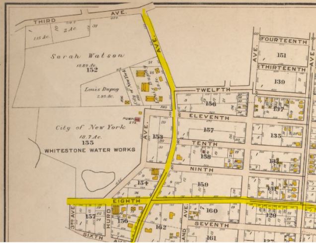
Notice how Parsons Boulevard takes a bow-shaped turn to the east of Whitestone Water Works, a property with a pond. Located to the north of this site, Whitestone was developed as a coastal village in the early 19th century, eventually expanding into a city neighborhood. In 1892, the village acquired the pond at Hurd Avenue (today’s 144th Street) for a pumping station that supplied water to the village. In 1898, the village was absorbed into New York City and soon after the city aqueduct was extended to serve Whitestone, making the pumping station obsolete.
The property was assigned as a park in 1936 as part of the Whitestone Parkway project that connected Whitestone Bridge to Flushing Meadows. The bridge, highway and playground opened in 1939.
The playground’s namesake is George Upton Harvey, one of just two Republicans to serve as Queens Borough President since this position was created. He served from 1929 to 1941, distinguished as a World War One veteran, fighter against corruption, communism, and fascism.
Roull with it

I could not find any historical photos of the pond or pumping station at Harvey Playground, but there is one forgotten element worth mentioning, Colonel Roullier. While there is official recognition of Harvey’s contributions to the city, the engineer who set aside the property for the Whitestone pumping station is unknown today. Through the records of the Brooklyn Daily Eagle, that name is revealed. Colonel Gustave A. Roullier. Born in 1849 to a French immigrant family, he studied engineering in France before returning home to design the water works of Baltimore, Flushing, and Newtown, and laid out Bell Boulevard in Bayside. Roullier was quite an active civic character. He belonged to many local fraternal organizations, bike club, and was active in the local firefighting unit.
Unfortunately on April 21, 1910, he was found dead in an apparent suicide. Witnesses said that he was in a “highly nervous state for some time past, and it is said that his business had been poor of late.” Roullier left a note for his son-in-law but its contents were never revealed to reporters.
What about Mill Creek?
Knowing that across the highway there are the super-blocks of College Point Industrial Park (more offices than industries) and the former Flushing Airport, I felt that the pond at Harvey Park may have had a connection to Mill Creek, the stream and wetland that separates College Point from the rest of Queens.

The 1904 E. Belcher-Hyde atlas shows Mill Creek meandering across an undeveloped expanse between College Point from Flushing. The triangular parcel bound by Linden Place, 20th Avenue and Whitestone Expressway would be used as Flushing Airport from 1927 through 1984. Today most of it is again a freshwater wetland with parks and office buildings along its periphery.
Seeing how close the pond was located to the headwaters of Mill Creek, I can say with confidence that it was part of the creek’s watershed. I will write about the history of this creek in the near future.
In the News:
Fast Company reports on the new park under construction on Governors Island.
CityLab reports on the effect of immigration on the design of Central Park.

A tangental note: Whitestone seems to go further back than the 19th Century. I have a picture of a British map of the Battle for New York dating back to 1776 that lists a “Whitestown” in about the current location of Whitestone.
LikeLike
re your sentence: “I could not find any historical photos of the pond or pumping station at Harvey Playground”….. I just came across this image which does show the pumping station.
http://digitalarchives.queenslibrary.org/browse/waterworks-and-greenhouses
LikeLike