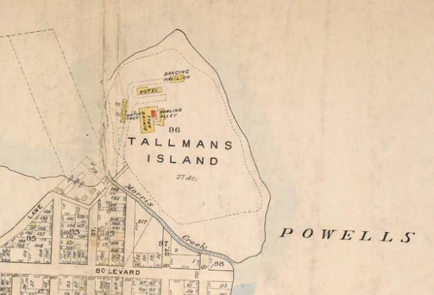
On the north shore of Queens is a former island fused to the borough. It was once a resort and today is a sewage treatment plant. The waterway that separated it from the rest of Queens was called Morris Creek.
The creek was narrow enough to jump over and the resort at Tallman’s Island is a faint memory, even more obscure than North Beach in East Elmhurst, when it comes to amusements on the north shore of Queens.
A Creek With a Name
The Morris name is quite visible around the city. There’s Morris Street in downtown Manhattan; and in the Bronx there are Morrisania, Morris Avenue, Morris Heights, Port Morris, and Morris Park. Why so many in the Bronx? It goes back to 1644, when the Morris family of England established its estate in what became the Bronx, retaining some tracts into the late 19th century when they were developed into neighborhoods that kept the family’s name. Did Morris Creek have any relation to this family?
The only clue I’ve found was a 1927 Brooklyn Daily Eagle article that mentioned that the island was owned by the Morris family from shortly before the Civil War through 1872, when it was leased to German immigrant Joseph Witzel, who developed the island as a resort. Nothing is said about this family’s connection to the famous Morrises of the Bronx. Subsequent maps described the island as Witzel’s Point and Point View Island, as well as Tallman’s Island.

From the collection of the Poppenhusen Institute, a neighborhood cultural and educational nonprofit, we have an old newspaper advertisement of Witzel’s resort.
Sewage Treatment on the Island
A sewage treatment plant is a necessity for any populated area but how can a city overcome neighborhood opposition and get one built? At the North River Wastewater Treatment Plant in Hamilton Heights, a park was built on its rooftop in 1987. At the time, precedents in Japan were cited as examples of utility facilities with parks on top. But there is another example of a utility with an amenity much closer to home. The design submitted by landscape architect R. L. Fowler Jr. had the island fused to the borough with nearly half of it reserved as a park. At the same time, notice the words on the lawns: future development. Fowler was no fool, he recognized that the city will continue to grow so will the sewage plant at Tallman Island.

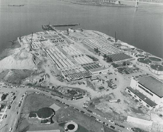
As the photo comes from the Municipal Archive, it has the watermarks. Pun intended. The plant opened in April 1939, celebrated in conjunction with other local infrastructure improvements of that decade that anticipated the 1939-1940 New York World’s Fair. It was the first sewage treatment plant in Queens and the third in the city, its location selected because Tallman Island sticks out into the East River, very close to the deep channel in the middle of it.

As expected, the undeveloped half of Tallman Island that appears in the 1940s image above was covered by an expansion of the aeration tanks by the 1960s. On the bottom of the photo below, Powells Cove Boulevard runs along the edge of the property, atop the former stream bed of Morris Creek. The “boulevard” was supposed to run from the western tip of College Point eastward to Cryder’s Point in Beechhurst but it was never completed and exists today in five separate segments.
Tallman Today

Since the 1960s, the treatment plant has continued to expand and modernize, taking untreated water from northeastern Queens. In June 2014, the city’s Department of Environmental Protection released a video on the 75th anniversary of the plant’s opening, describing its history of service to the city. Another useful set of documents on Tallman Island’s history and future comes from the Tallman Island Water Pollution Control Plant Upgrade Program, published in 2009 on the DEP website.
As Morris Creek’s namesake is a mystery to so is Tallman’s name. Was it the surname of a local property owner? Perhaps it was a Native name for the island that was translated into English?
Tallman Island was not mentioned in The Other Islands of New York City. This book does include Broad Channel, Roosevelt Island, and Rikers Island. The latter two are not administratively within Queens, but their only connection to land is through Queens
Want more on College Point’s Shoreline?
I have a photo essay about the coastline of College Point on Forgotten-NY.
Meet the Author:
I will be speaking on September 15 at 6 p. m. at Steinway Library on the subject of hidden waterways in western Queens. Books will be on sale as part of the presentation. The address is 21-45 31 Street in Astoria, Queens.

3 thoughts on “Morris Creek, Queens”