Thurston Creek, Queens

As its name suggests, Springfield Boulevard in southern Queens used to run past a field with a spring from which a stream originated. That stream is Thurston Creek, which its had its source near Springfield Boulevard and 121st Avenue, across from Montefiore Cemetery in the neighborhood of Springfield Gardens. It flowed south along Springfield Boulevard for nearly three miles, emptying into Jamaica Bay.

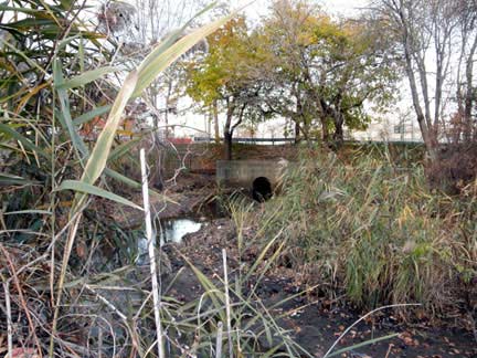
The creek emerges to the surface in Springfield Park, a 24-acre green space where the creek flows through a brick channel, widening into Cornell’s Pond before continuing south into the Idlewild marshes.

Continue reading

Fort Totten Ponds, Queens

On the northeast tip of Queens is a 249-acre peninsula that was the last military base in the borough prior to its closing in 1995. A favorite haunt of urban explorers, Fort Totten Park may not receive as many tourists as Governors Island, but the story of this base-turned-park has been documented by many writers. For the purposes of my book, I’ve focused on the two ponds separating the fort from mainland Queens.

totten 1.jpg

They are nearly impossible to access, as the larger pond is on the part of Fort Totten that has been retained by the army for its reserves, and the other is enveloped by marshes off the shoulder of Cross Island Parkway. Continue reading

Rejected Landscapes for Flushing Meadows

The radiating boulevards of Flushing Meadows-Corona Park have been a defining feature of the park since they were proposed in 1937 by Gilmore Clarke and Charles Rapuano as part of the great transformation of a former ash dump into a thousand-acre World’s Fair site and park. At the time, the flat and barren terrain gave Flushing Meadows the look of a blank slate, open to any ideas that would shape its future as a park.

cornell aerial

From the Cornell University archives, a 1936 Fairchild Aerial survey shows Meadow Lake beginning to take its form. The core of the park to the north of the lake is the subject of this essay. Had the Versailles-inspired boulevards not been selected, what would have been the park’s appearance?

Continue reading

Gabler’s Creek, Queens

In the hilly terrain separating Douglaston and Little Neck neighborhoods, Gabler’s Creek runs through a ravine on its way to Little Neck Bay at Udalls Cove. The marsh at the stream’s mouth straddles the city line. Thanks to determined local residents, the stream runs undisturbed within the Udalls Cove Park Preserve.

IMG_3386.JPG

Although the history of Udall’s Cove since 1969 appears to be a success story, it is not resolved. With 15 privately owned lots remaining within the ravine, development remains a threat to the cohesion of the preserve. Over the past half century, the city and state have acquired private parcels in a piecemeal manner.

Continue reading

Rejected Races at Meadow Lake

In the 80-year history of Meadow Lake, there have been plans for the waterway that did not go beyond the planning phase. Having examined designs for a never-built mid-lake bridge, I will now look at the 1980s plan to install a racetrack around its shores.

1983 grand prix.jpg

From the 1983 map by Wilson Racing, the outline of the lake appears unchanged, but can one imagine the impact on the park if the Grand Prix proposal had happened?

Continue reading

Formation of Meadow Lake, Queens

The city’s largest freshwater lake offers enough details in its design and history to allow for multiple posts. Having previously focused on the Aquacade that stood at Meadow Lake, and the history of Jewel Avenue Bridge, I turn to its northwest corner, where Horse Brook had its confluence with Flushing Creek.

interlakes 2

On the above image, the red triangle shows the location of my parents’ home, which will be built atop the filled Horse Brook stream bed in 1950.

In the time between this 1937 photo and the opening of the 1939 World’s Fair, the transformation of the wetlands along Flushing Creek into Flushing Meadows is one of the most unrecognizable landscape alterations in the city in the past century. Around Meadow Lake, it includes a few rejected proposals worth remembering.

Continue reading

Crocheron Pond, Queens

When there are two large parks bordering each other, would it make sense to combine them under a single name? Not when each has a unique history and namesake worth keeping. In the Queens neighborhood of Bayside, the 46-acre Crocheron Park borders the 17-acre John Golden Park, but it is Crocheron that contains an internal waterway, Crocheron Pond.

pond east

Crocheron Pond has also been known over the decades as Golden Pond, but it doesn’t have a direct connection to nearby John Golden Park. This kettle pond is separated from the salt water of Little Neck Bay by a thin neck of land.

Continue reading

Kissena Corridor Park, Queens

Since this blog was launched in December 2015, I’ve documented the city’s hidden waterways with as much detail as possible, but then after publishing the pieces, I stumble upon more old photos, maps, and postcards of the published streams.

1940 QBG full.JPG

The photo of note here is this August 1940 aerial survey of the first World’s Fair at Flushing Meadows, looking east. It is a Parks Department photo from the Municipal Archives collection. The corridor of open land between the street grids of downtown Flushing and Queensboro Hill is today’s Kissena Corridor Park, where Kissena Creek used to flow.

Continue reading

Baisley Pond, Queens

After my visit to the site of One Mile Pond, I felt it was a good opportunity to travel downstream and document the story of Baisley Pond, the largest lake in southern Queens.

baisley view.JPG

Having visited this park after a morning snowfall, the terrain was muddy and there were few people to be seen. It is a post-glacial landscape akin to when mastodons roamed the earth. In 1858, the remains of this creature were unearthed by the pond by construction workers who were transforming the pond into a reservoir.

Continue reading

One Mile Pond, Queens

I was recently emailed by a researcher at the DEP about street flooding in Jamaica, Queens and its likely connection to a long-gone waterway known as One Mile Pond. It is a pond so obscure that it did not make the cut into the Hidden Waters book and I could not find too many sources online for its location and name.

OLYMPUS DIGITAL CAMERA

The clue offered to me was that this pond was located upstream from Baisley Pond. A quick comparison of historical maps led me to St. Albans Memorial Park, an 11-acre expanse of green space built atop the former One Mile Pond.

Continue reading