There was once a time when Brooklyn was a city that rivaled Manhattan and attempted to have everything that the island borough has, such as its own art museum, botanical garden, and major league baseball team. It also had its own version of Central Park, designed by the same landscape architect duo. While Central Park has numerous unconnected waterways that were adapted from natural streams on site, Brooklyn’s 585-acre Prospect Park has only one waterway, carved entirely from the landscape.
Initially fed by water from a well, the stream emerged from the ground through the manmade Fallkill Falls. The landscape of the brook was inspired by the Adirondack wilderness with a heavily forested rocky terrain that carried the stream through numerous waterfalls, rapids and lakes.
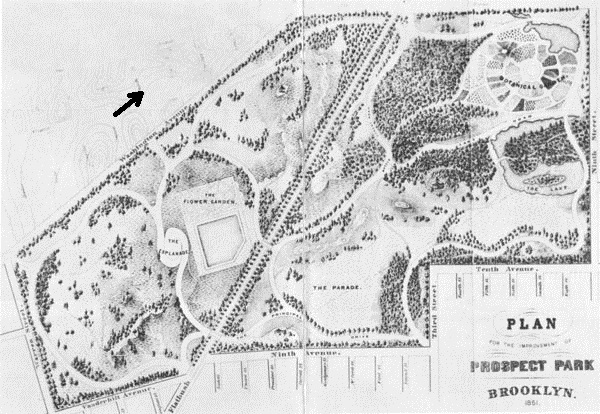
Following the Stream
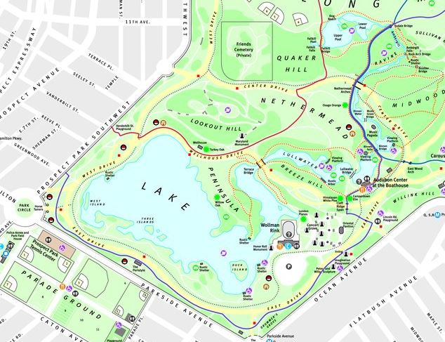
While Prospect Park does not have multiple streams, its single internal waterway descends down six cascades and carries four names on its descent towards Prospect Park Lake: Falkill, Ambergill, Binnen Water, and Lullwater. Each name is inspired by local history and has a uniquely designed appearance.
Falkill Falls
As its name suggests, the stream begins with a waterfall that appears to emerge from exposed rocks. It empties into Fallkill Pool, then descends further into the larger Upper and Lower Pool. Initially, the water came from a well in the park. The waterfall shares its name with a stream upstate in Dutchess County.
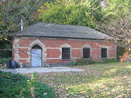
Located at the foot of Lookout Hill, the Well and Boiler House was completed in 1869 and contained the machinery that pumped 750,000 gallons of water into the park’s waterways. In the 1930s, the city’s aqueduct was connected to the park’s water system and the well was no longer needed.
The building’s 50-foot diameter underground reservoir and smokestack were torn down and the building stood as a forgotten structure in the borough’s most defining park. In 2013, the building was given a new use as an eco-friendly restroom that would recycle human waste into fertilizer.
Upper and Lower Pool
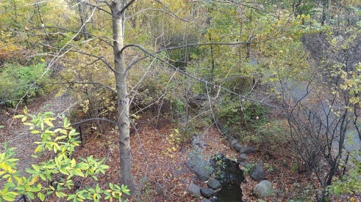
The most ideal time for photographing waterways is winter, when there is less foliage obscuring the view. Taken from the wooden Fallkill Bridge, we see the stream’s second cascade taking the water into Upper Pool and Lower Pool, these connected lakes feature a beach for dogs and a bird sanctuary isle.
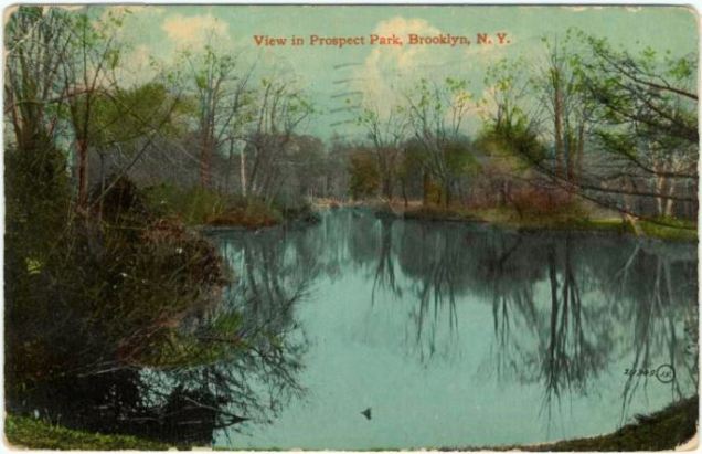
In the above 1911 colorized postcard by Leighton & Valentine, we see Upper Pool and Lower Pool in an appearance resembling somewhere upstate, a welcome respite from the city. Previously this lake was also known as Swan Boat Lake, Wild fowl Pond, and The Pools.
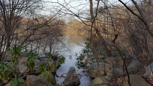
Ambergill
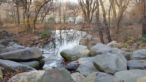
On the downstream side of this lake is Esdale Bridge, a rustic wooden footbridge above Ambergill Falls, where the stream takes on the name Ambergill as it enters The Ravine.
Ambergill was a name was personally chosen by Olmsted. Gill is an Old Norse word for creek. Central Park also has a constructed brook in its Ramble section called The Gill. A few streams in northern England appear on the map as gills.
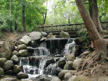
The Ravine is the section of Prospect Park that corresponds to The Loch in Central Park, a seemingly wild terrain of rocks, forests and streams tucked inside the park. The landscape must be carefully managed. As erosion takes its natural course, sediment collects in the 100-foot wide gorge, blocking the stream. Only through human intervention does the stream continue to flow uninterrupted through The Ravine. Within the Ravine is the stream’s third cataract, Ambergill Falls, with Rock Arch Bridge offering views of the cascade.
Binnen Water
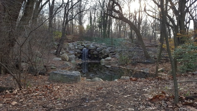
So far, we’ve seen the park’s stream carry a Dutch name with Falkill and a Norse name with Ambergill. At its fourth cataract, it becomes Binnen Water, from the Dutch word for “within” indicating its location in the center of the park.
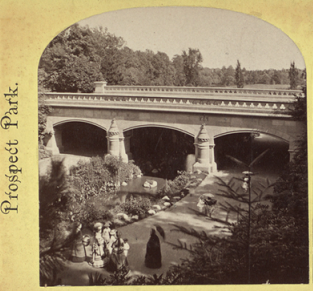
The Binnen Water is best observed from the Nethermead Arch, a grand crossing that takes Center Drive across the stream. It comprises of three arches, for the pedestrian path, waterway and bridle path.
Seen on the right in an 1870s stereoscopic view, Nethermead is the most elaborate of the park’s stone arches. Its namesake is the nearby meadows whose name signifies its place deep inside the park. In contrast to the Long Meadow, the Nethermead is smaller in size, framed by Quaker Hill, Lookout Hill, and the Binnen Water. This section of the stream is also crossed by Music Grove Bridge, named after the Music Pagoda that overlooks the stream.
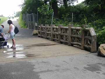
Binnen Water descends to the stream’s fourth name at Binnen Falls, historically known as Bridal Veil Falls. It is the final cataract on the stream as it descends into Lullwater. The rustic bridge is a recent reconstruction of the original Olmstedian design, made possible through the philanthropy of Prospect Park Alliance. Although swimming is prohibited in the stream, it is common to see youths splashing here in the summer.
Lullwater and the Boathouse
The final phase of the stream is Lullwater, where the current slows and the waterway widens into a basin large enough for boats to use. Its shape and landscape were inspired by The Serpentine in London’s Hyde Park. That waterway is a remnant of the River Westbourne that is almost entirely underground these days. The centerpiece of Lullwater is the Boathouse, which houses the Audubon Center. It is also a popular wedding venue.
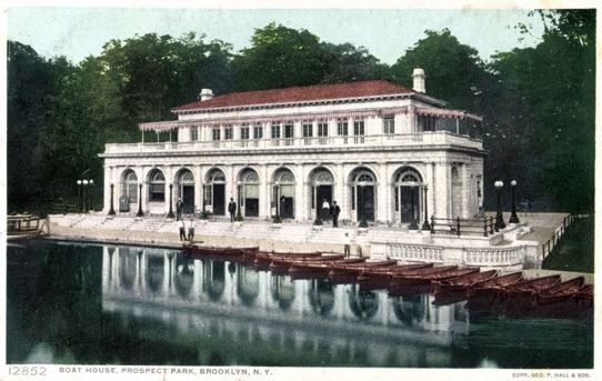
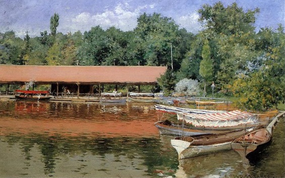
The architecture firm of Helme & Huberty designed the structure in the beaux arts style with the library of St. Mark’s Cathedral in Venice as the inspiration. The boathouse replaced an earlier wooden structure constructed in 1866. As this blog follows in the tradition of Forgotten-NY of documenting structures that are no longer here, I found an image of the original Boathouse, painted by William Merritt Chase in 1887 in the impressionist style. It appeared identical to the original boathouse of The Lake in Central Park. It was razed in 1924.
The architects learned their profession from the firm of McKim, Mead & White, the prestigious beaux arts designers of the Old Penn Station. In the years following the Second World War, public use of the boathouse declined sharply. Like the Old Penn Station, it was slated for demolition in 1963. Its removal was approved by the City Planning Commission, the Board of Estimate and the mayor before the opposition mobilized to save it.
Among those defending the structure were the Brooklyn Borough President, the Municipal Art Society, Brooklyn Bird Club and numerous local civic organizations. Among the defenders was Manhattan attorney Robert Makla, who described Prospect Park as a work of art. “It’s a creation just as a work of music or a theatrical piece.” Makla’s description of the park is a stark contrast from an earlier description of the Boathouse in the New York Times as a “gaslight relic.”
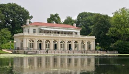
The building presently serves as an education center run by the Audubon Society, which had its grand reopening of the boathouse on April 26, 2001, the joint birthday of John James Audubon and Frederick Law Olmsted.
It is no longer used for boat or ice skate rentals.
Bridges Across Lullwater


From the Forgotten-NY page on the Bridges of Prospect Park, we see Lullwater Bridge on the left and Terrace Bridge on the right. They are the only two automobile roads crossing the stream. Lullwater Bridge is the longest crossing in Prospect Park. Completed in 1906 it is made of cast-iron, reminiscent of Bow Bridge in Central Park.
A larger cast-iron creation, Terrace Bridge takes Wellhouse Drive over Lullwater. Beneath the bridge, a walkway lines the water’s edge. The hilltop terrace with a Refectory (restaurant concession) to which its road was intended to lead was never completed, victim of the financial Panic of 1873. As the water passes under the bridge, it widens into Prospect Park Lake
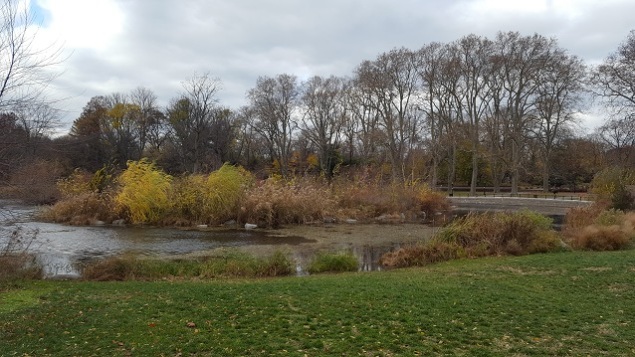
Prospect Park Lake
The largest inland by of water in Brooklyn is the 60-acre Prospect Park Lake, which appears in the shape of a swan on the map.
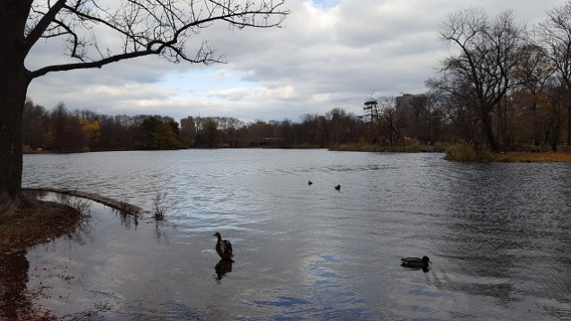
On rainy days as seen above, the lake can overrun its banks. To keep the stream within its course, East Drive on the southern side of the lake runs atop an embankment. The neighborhood to the immediate south of the park is at a lower elevation than the lake. With its numerous islands, coves and peninsulas, it has the appearance of an inland sea but it was entirely manmade.
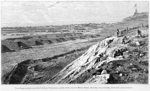
An illustration from the 1870s shows a view of the lake site from Lookout Hill, showing its outline carved out of the landscape with the soil piled up in mounds. From the detailed book Frederick Law Olmsted: Plans and Views of Public Parks, we see a before-and-after transformation of Flatbush farmland into Prospect Park Lake.
Music Island
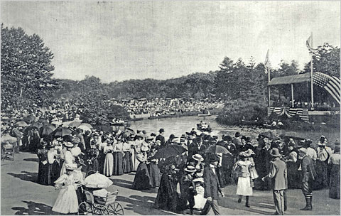
At the northeast corner of the lake is Music Island, a bird sanctuary isle that was conceived in the park’s original design.
Located inside a circular cove, it served as a stage for musicians who rowed to the island with their instruments as spectators watched from a location on the shoreline called Concert Grove. As Olmsted envisioned it, park goers would pass by the music-playing island and imagine that the park had its own ambient soundtrack that complemented the landscape. Eventually, the poor acoustics drove the musicians to other locations in the park.
Once and Again Music Island
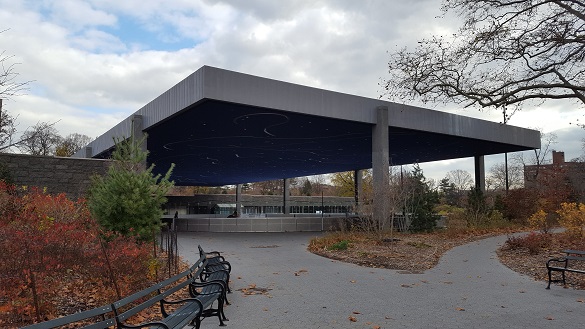
In 1960, ice skating was no longer safe on the lake and Parks Commissioner Robert Moses eliminated the half-acre island by constructing Kate Wollman Rink on top of it. The Concert Grove paths that approached the island now faced a chain-link fence, as did the Abraham Lincoln statue that once faced the island. A 1967 guidebook to the park by its former curator used described the grove as a “catastrophe,” “wrecking,” “desecration” and “obliterating.”
In the first decade of the 21st century, the nonprofit Prospect Park Alliance proposed a $70 million project called Lakeside. The largest project in the park since the 19th century, Lakeside restored Music Island to its location while moving the ice skating rink to a underused parking lot nearby. Nearby Teardrop Island was also included in the shore restoration.
In a nod to philanthropy, the October 19, 2012 ribbon cutting for Riverside bestowed on the park the following names: Chaim Baier Music Island, Shelby White and Leon Levy Esplanade and the Samuel J. and Ethel LeFrak Center at Lakeside.
The facility’s designers were the celebrated spouse-partnership of Billie Tsien and Tod Williams, along with landscape architect Christian Zimmerman. The new LeFrak ice skating rink is located on the site of the parking lot of the old Wollman Rink, near the shore of the lake.
Rustic Shelter
As with Central Park’s lake, the one in Prospect Park features rustic shelters along its shore offering a place to sit and admire Brooklyn’s largest inland waterway, its only lake.
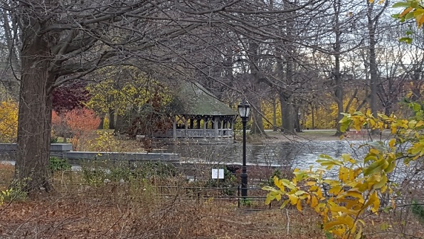
Near the rustic shelter at the lake’s southeast corner used to be Ford Bridge, a wooden crossing on a cove in the lake. Part of the park’s bridle path, this is where horses could dip their hooves in the water. The bridge and its cove were eliminated by 1916. Presently the lawn by the shelter is a designated barbecue area.
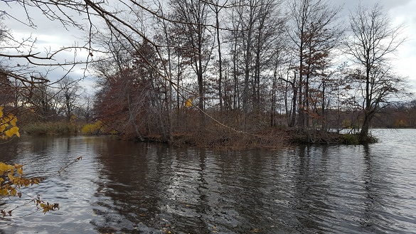
Within the lake, other islands that serve as bird sanctuaries are Duck Island, Three Islands and West Island. The shoreline of the lake has numerous coves and peninsulas appearing as an inland sea.
Unbuilt Prospect Park
Before the Olmsted-Vaux plan for the park was approved, the initial layout for the site was submitted by Egbert Ludovicus Viele in 1861, putting Mount Prospect Reservoir in its center with Flatbush Avenue slicing through the park.
The site of Lullwater was also envisioned by Viele as a lake, along with a botanical garden on its banks. A second lake would have been carved in a woodland where Falkill is located. The park’s southern border would have been Ninth Street rather than Fifteenth Street that is Prospect Park Southwest.
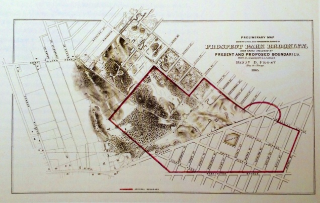
Olmsted and Vaux were troubled with Flatbush Avenue bisecting the park in its unnaturally straight path and made Flatbush Avenue as the park’s eastern border. A portion of Viele’s eastern half of the park later became the Brooklyn Botanical Garden and the Prospect Heights neighborhood. On the above Benjamin D. Frost survey of the site, the red line indicates Viele’s park borders while the shaded areas to its south show where the park was extended by Olmsted and Vaux. Notice how the hills and farms on the site did not have natural streams on it, in contrast to the Central Park site.
Books on Prospect Park
Prospect Park has a rich history and I could not have written my chapter on it without a few excellent sources. Every stream has its tributaries and every good book has its sources. Here are a few on Prospect Park:


Other Waterways in the Park:
Prospect Park has a smaller pond in its Vale of Cashmere and the Brooklyn Botanical Garden has the Japanese Hill-and-Pond Garden. The park also had a reservoir on a hilltop adjacent to the Brooklyn Public Library.
In the News:
DNAinfo reports on plans to install a zipline across the Bronx River in Bronx Zoo. My opinion: bring back the Skyfari.
Curbed contributor Nathan Kensinger provides a photo essay on Saw Mill River in Yonkers, the largest daylighting project in New York.

Hi
I’m trying to reach you. I hope you OK . I left you a message on Facebook.
Please contact me on the phone number that I left you on facebook.
Thank you
LikeLike
I did not receive your message.
LikeLike
Excellent post, with lots of information and photos/postcards I’d not previously seen.
LikeLike
Very interesting. This is the first time I’ve seen your blog..I linked to it from a story in another local blog. I’ve loved the park and especially the lake since the first time I went there about 30 some odd years ago. I love Brooklyn history in general and this is a great piece about the waterways in prospect park.
LikeLike