Shaped by the glaciers of the most recent ice age, the terrain of the Bronx is a series of north-south ridges with streams flowing in the valleys between them. An example of such a valley is Mullally Park, where the new Yankee Stadium stands. A century before the massive sports cathedral was completed, a creek ran through the park, named after an English family that briefly overthrew the monarchy and later fled to the colonies.
The only visible reminders of this buried Bronx stream are Cromwell Avenue, which was constructed parallel to the stream bed, and the approach to Macomb’s Dam Bridge, which is elevated above the valley in which Mullally Park lies.
Prior to the arrival of European settlers, the creek was known to local natives as Mentipathe. It originated in the present-day neighborhood of Morris Heights, approximately near the corner of Grand and Burnside Avenues. At its headwaters, the neighborhoods of Mount Eden and Mount Hope also indicate the challenging topography in this section of the city. The stream flowed into the Harlem River at a point just south of present-day Macomb’s Dam Bridge.
In its Natural State
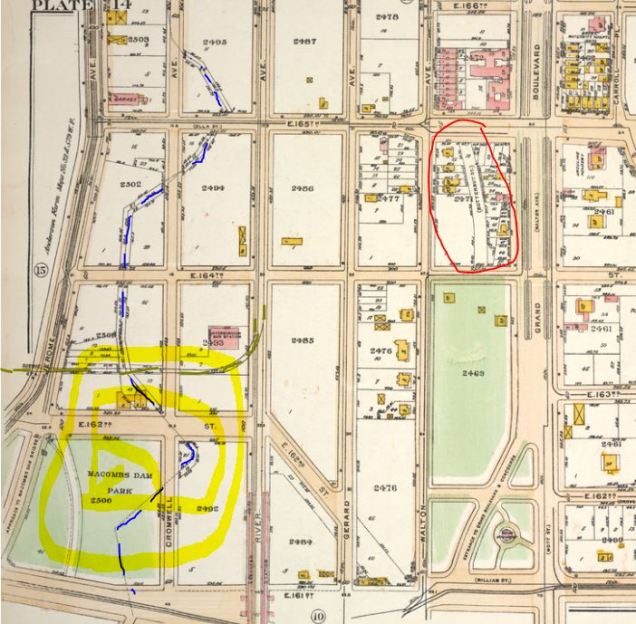
In the 1873 topographical map commissioned by the Parks Department, the prescribed street grid is laid out across an undeveloped Bronx landscape. For reference, I illustrated the path of Cromwell’s Creek and new Yankee Stadium. On a slightly related note of neighborhood trivia, I circled in red the location of Butternut Street, one of the most obscure pre-grid roads in the borough.
The Namesake Family
In 1685, John Cromwell, nephew of England’s short-lived Puritan junta leader Oliver Cromwell, had settled in the Bronx after a stay in Holland. Around 1770, his descendant James Cromwell purchased mill on the creek built a decade earlier. The nearby family house survived into the early twentieth century, located at the corner of 165th Street and Jerome Avenue. The photos below from the Museum of the City of New York (MCNY) show the Cromwell House circa 1910. By them, most of Cromwell’s Creek had been buried. Although James Cromwell relocated upstate to Orange County after the Revolution, his last name did not leave the creek. The MCNY collection shows that mill pond was a popular ice skating site, ask was the case with other mill ponds across the city.
Industries on the creek
Much of the land surrounding the Cromwell mill belonged to the Morris family, colonial aristocrats who purchased their portion of the future borough from borough namesake Jonas Bronck in 1670s. Their manor was named Morrisania and portions of it remained in the family’s possession into the late 19th century. On the borough’s map, one may also find Morris Avenue, Morris Park, Morris Heights, and Port Morris. The Trumps of their time.
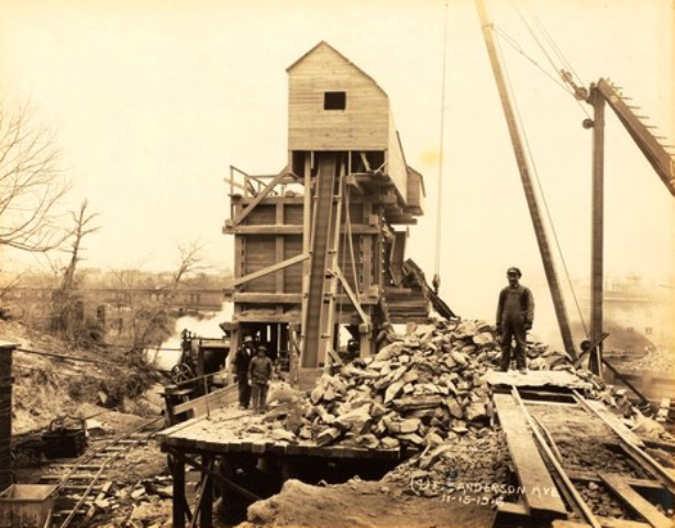
In 1880, William H. Morris sold some of his Bronx properties to land speculator John Jacob Astor . The lots included water rights to Cromwell’s Creek. Tenants along the creek included coal dealers John M. Tierney, William F. Porter, and Carrie T. Porter (Tierney & Porter), who opened shop at 161st Street and Jerome Avenue in 1888; and in 1891, Clifford L. Miller & Co., a brick and cement manufacturer. The above photo comes from the NYPL photo collection.
Covering the Creek
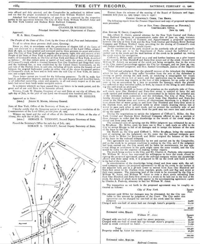
By 1906, the creek had seen little use and was becoming too shallow for boats to use. Property owner William W. Astor approached the city and the New York Central Railroad to have the stream buried. In the City Record of February 17, 1906, the request was granted. A map shows that by then, all that had remained of Cromwell’s Creek was a portion south of 161st Street.
The Yankees Arrive
In 1921, New York Yankees owners Jacob Ruppert and Tillinghast l’Hommedieu Huston, purchased a 10-acre lumberyard between 157th and 161st Streets at River Avenue from Astor. Construction commenced on May 5, 1922 and the world’s biggest baseball stadium was completed in time for the following year’s playing season.
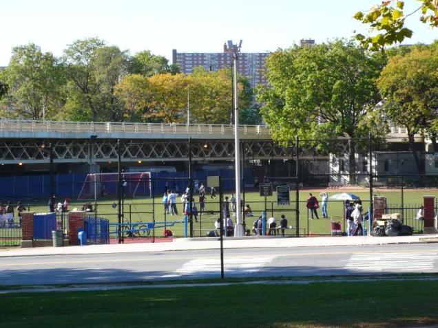
In the photo above, the newly-completed stadium is nestled between the elevated tracks of the Jerome Avenue Line and the approach to Macomb’s Dam Bridge. Near the bridge’s Bronx side is a small cove, all that remains of Cromwell’s Creek. In 1924, the undeveloped land atop the former stream bed was designated as parkland by the city, and named after parks advocate John Mullally.
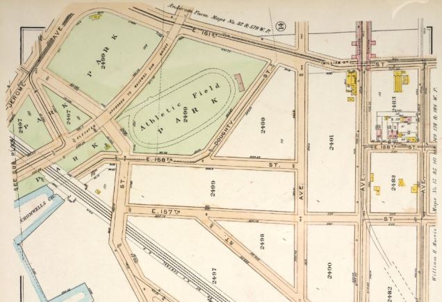
A 1921 Bromley map below shows the area’s unbuilt streets and the athletic field of Macomb’s Dam Park. This park was acquired in 1897 and later was expanded with the addition of Mullally Park to its north. The athletic field is still there today, carrying the name of Joseph James Yancey. The old Yankee stadium would be built on blocks 2400, 2401, and 2409, adjacent to the park.
A Forgotten Railway
To the north of Macomb’s Dam Park, the 1921 map shows the former stream bed delineating property lines. Butternut Street is circled and the new Yankee Stadium, completed in 2009 is highlighted. Notice that there were railroad tracks running to the north of 162nd Street.
In 1918, the Ninth Avenue Elevated line was extended north from its terminus at the Polo Grounds across the Harlem River, connecting with the Jerome Avenue line. By 1940, the city’s oldest rapid transit line was demolished south of 155th Street and the extension between the Polo Grounds and the Bronx functioned as a shuttle bringing Bronx spectators to games at the uptown ballpark. When the baseball Giants departed for San Francisco in 1957, the shuttle was discontinued. The elevated section at 162nd Street was dismantled, while its two stations at Sedgwick Avenue and Jerome-Anderson Avenues were abandoned and served as homeless encampments.


Aside from the bricked-up abandoned stations, another remnant of the Polo Grounds Shuttle are stub tracks departing from the Jerome Avenue Line at 162nd Street, terminating abruptly where they once crossed over Mullally Park.
Heritage Field
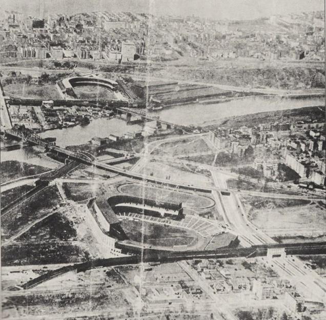
The construction of the new Yankee Stadium meant the loss of parkland, which was conveniently replaced with new parks on the site of the old stadium and along the nearby Harlem River shoreline. As the map below shows, the city tightly fit onto the former stream bed a series of new parks, parking facilities, and a new Metro-North station.
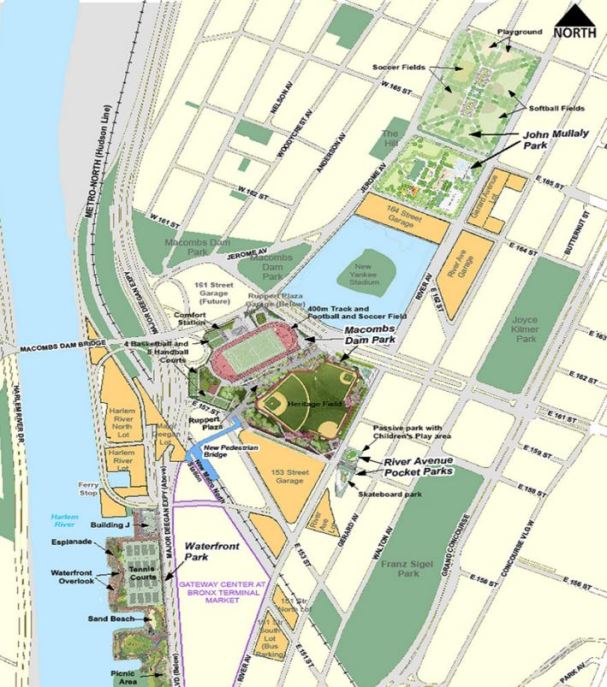
On the site of old Yankee Stadium, Heritage Field serves as the replacement park, bearing hints of the House that Ruth Built.
If the stream’s course were reconstructed, it would flow through the heart of the new stadium.

If one wishes to experience what it would have felt like to visit Cromwell’s house, the nearby Poe Cottage offers a look at how people lived in the once-rural Bronx. Considering the apparent sanctity that the stadium has for many sports fans, I will not illustrate puddles on the outfield.

Nearby River Avenue, named after Cromwell’s Creek was given a punny tribute to 19-season pitcher Mariano Rivera as Rivera Avenue in May 2014. Nevertheless, Cromwell’s name is receiving a much more prominent place on the map with the 57-block valley dubbed by city planners as “Cromwell-Jerome.” We’ll see if the name sticks. It sure beats a silly acronym like SoBro or the loaded Piano District that recently appeared in the South Bronx.

Great Article. They bottom center home of the picture of the stadium being built was our ancestors home. In front of the El next to the crease in the page. It was purchased from Cromwell family in the late 1850’s and built by Moses Sherwood and his son Samuel Jackson Sherwood as a multi generational home.
LikeLike
Interesting. When was this home demolished?
LikeLike